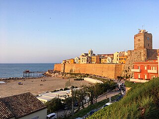
Termoli is a comune (municipality) on the south Adriatic coast of Italy, in the province of Campobasso, region of Molise. It has a population of around 32,000, having expanded quickly after World War II, and it is a local resort town known for its beaches and old fortifications. Once it was known only as a fishing port, but in the new millennium it is a favourite resort for Italian families. Termoli contains the only port of the Molise region. There is also a strong competition with the Campobasso province, in fact some of the "termolesi" like to say that Termoli is province-less.

The province of Chieti is a province in the Abruzzo region of Italy. Its provincial capital is the city Chieti, which has a population of 50,770 inhabitants. The province has a total population of 387,649 inhabitants as of 2017 and spans an area of 2,599.58 square kilometres (1,003.70 sq mi). The province contains 104 comuni. Its provincial president is Mario Pupillo.

Monte Sant'Angelo is a town and comune of Apulia, southern Italy, in the province of Foggia, on the southern slopes of Monte Gargano. It is one of I Borghi più belli d'Italia.

Castelbuono is a town and comune in the Metropolitan City of Palermo, Sicily.
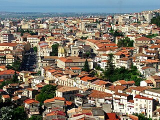
Lamezia Terme, commonly called Lamezia, is an Italian city and comune of 70,452 inhabitants (2013), in the province of Catanzaro in the Calabria region.

Fiumefreddo di Sicilia is a comune in the Metropolitan City of Catania on the coast of the Ionian Sea on the island of Sicily, southern Italy. It shares its borders with the municipalities of Calatabiano to the north, Mascali to the south and Piedimonte Etneo to the west.
San Mango d'Aquino is a town and comune in the province of Catanzaro, in the Calabria region of southern Italy. This town was recently rejuvenated by several construction programs designed to improve access for tourism.

San Rufo is a village and comune in the province of Salerno, in the Campania region of southern Italy located in the Vallo di Diano. San Rufo extends over 31 square kilometres, much of which is mountainous or hilly terrain. With defence in mind, the old town was built at over 600 meters above sea level. Another reason for the choice of location was the marshy nature of the wide Vallo di Diano plain, which sits at an average 450 metres above sea level.

Colico is a town and comune in the province of Lecco, in Lombardy in northern Italy. It is situated on the northern arm of Lake Como, where the river Adda enters the lake. Colico is the largest town in the northern part of Lake Como, which is often identified as its Colico branch.

Ginosa is a small town and comune in the province of Taranto, Apulia, southern Italy.
Altilia is a town and comune in the province of Cosenza in the Calabria region of southern Italy. The comune includes the frazione of Maione.
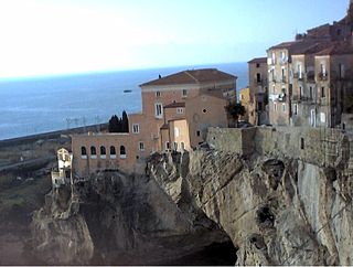
Amantea is a town, former bishopric, comune (municipality) and Latin Catholic titular see in the province of Cosenza in the Calabria region of southern Italy.

Grimaldi is a town and comune in the province of Cosenza in the Calabria region of southern Italy. Grimaldi is referred to as Grimaldo in historic documents. In the local Calabrian dialect, the town is called Grimàudu or Grimàuru, and the residents Grimaudisi, although the Italian versions are today prevalent.

Piadena is a former comune in the Province of Cremona, Italy. On January 1, 2019 it merged with Drizzona to form Piadena Drizzona.
Mandello Vitta is a comune (municipality) in the Province of Novara in the Italian region Piedmont, located about 80 kilometres (50 mi) northeast of Turin and about 13 kilometres (8 mi) northwest of Novara.

Tavernes de la Valldigna is a municipality in the Valencian Community, Spain, located in the district of Safor, 54 km far away from Valencia. It is the biggest town in La Valldigna, a horseshoe shape valley bordered by mountains on the west and the Mediterranean Sea to the east. Tavernes gained a City title in December 1916, by King Alfonso XIII. The mayor is Jordi Juan Huguet (2011-). According to the Spanish Statistic National Institute, INE, in 2010 there were 18.130 inhabitants in Tavernes: 9.126 men and 9.004 women.

Colletorto is a comune (municipality) of approximately 1,786 inhabitants in the province of Campobasso, in the Italian region of Molise, located about 45 kilometres (28 mi) from the capital of the region Campobasso and 40 kilometres (25 mi) from Termoli (CB), sea town with port, railway and highway A14.

Raffadali is a comune (municipality) in the Province of Agrigento in the Italian region of Sicily, located about 80 kilometres (50 mi) south of Palermo and about 10 kilometres (6 mi) northwest of Agrigento.

Motta Sant'Anastasia is a comune (municipality) in the Metropolitan City of Catania in the Italian region Sicily, located about 160 kilometres (99 mi) southeast of Palermo and about 9 kilometres (6 mi) west of Catania.

Campora San Giovanni is a frazione (borough) of the comune (municipality) of Amantea, in the province of Cosenza, Calabria, Italy, located close to the border with the province of Catanzaro.


