Belmonte Calabro, known simply as Belmonte prior to the proclamation of the Kingdom of Italy, is a town and comune in the province of Cosenza, in Calabria. The town is perched on a hilltop on the coast of the Tyrrhenian Sea.
Jacurso is a village and comune in the province of Catanzaro in the Calabria region of southern Italy.

Pertosa is a village and comune of the province of Salerno in the Campania region of south-west Italy. In 2010 its population was 714.

Romagnano al Monte is a village and comune of the province of Salerno in the Campania region of southern Italy.
Castrignano del Capo is a town and comune in the province of Lecce in the Apulia region of south-east Italy. It has three Villages: Santa Maria di Leuca, Giuliano, Salignano.

Terravecchia is a village and comune in the province of Cosenza in the Calabria region of southern Italy.
Scala Coeli is a village and comune in the province of Cosenza in the Calabria region of southern Italy.
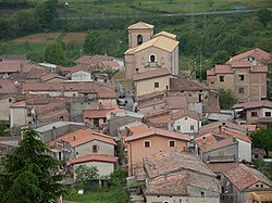
Rogliano is a town and comune in the province of Cosenza in the Calabria region of southern Italy. It's located in the Savuto Valley. It was mostly destroyed in a violent earthquake in 1638. The town is 19 kilometers (12 mi) from Cosenza.

Imèr is a comune (municipality) in Trentino, located about 50 kilometres (31 mi) east of Trento in northern Italy. As of 31 December 2004, it had a population of 1,213 and an area of 27.6 square kilometres (10.7 sq mi).

Oltrona di San Mamette is a comune (municipality) in the Province of Como in the Italian region Lombardy, located about 35 kilometres (22 mi) northwest of Milan and about 12 kilometres (7 mi) southwest of Como. As of 31 December 2004, it had a population of 2,190 and an area of 2.7 km².

Aviatico is a comune (municipality) in the Province of Bergamo in the Italian region of Lombardy, located about 60 kilometres (37 mi) northeast of Milan and about 12 kilometres (7 mi) northeast of Bergamo. As of 31 December 2007, it had a population of 515 and an area of 8.4 square kilometres (3.2 sq mi).

Colzate is a comune (municipality) in the Province of Bergamo in the Italian region of Lombardy, located about 70 kilometres (43 mi) northeast of Milan and about 20 kilometres (12 mi) northeast of Bergamo. As of 31 December 2004, it had a population of 1,638 and an area of 6.7 square kilometres (2.6 sq mi).

Orio al Serio is a comune (municipality) in the Province of Bergamo in the Italian region of Lombardy, located about 45 kilometres (28 mi) northeast of Milan and about 1 kilometre (1 mi) southeast of Bergamo.

Serina is a comune (municipality) in the Province of Bergamo in the Italian region of Lombardy, located about 60 kilometres (37 mi) northeast of Milan and about 31 kilometres (19 mi) northeast of Bergamo. As of 31 December 2004, it had a population of 2,214 and an area of 27.6 square kilometres (10.7 sq mi).

Valbondione is a comune (municipality) in the Province of Bergamo in the Italian region of Lombardy, located about 90 kilometres (56 mi) northeast of Milan and about 45 kilometres (28 mi) north of Bergamo. It is surrounded by the Orobie Alps. As of 31 December 2004, it had a population of 1,156 and an area of 95.0 square kilometres (36.7 sq mi).

Fortunago is a comune (municipality) in the Province of Pavia in the Italian region Lombardy, located about 91 km south of Milan and about 42 km south of Pavia. As of 31 December 2004, it had a population of 407 and an area of 18.0 km².
Mezzanino is a comune (municipality) in the Province of Pavia in the Italian region Lombardy, located about 35 km south of Milan and about 7 km southeast of Pavia. As of 31 December 2004, it had a population of 1,435 and an area of 13.9 km2.

Tarzo is a comune (municipality) in the Province of Treviso in the Italian region Veneto, located about 60 kilometres north of Venice and about 35 km (22 mi) north of Treviso. As of 31 December 2004, it had a population of 4,671 and an area of 23.8 square kilometres (9.2 sq mi).

Piove di Sacco is a comune (municipality) in the Province of Padua in the Italian region Veneto, located about 25 kilometres (16 mi) southwest of Venice and about 20 kilometres (12 mi) southeast of Padua. As of 31 December 2004, it had a population of 18,019 and an area of 35.6 square kilometres (13.7 sq mi).
Sant'Angelo di Piove di Sacco is a comune (municipality) in the Province of Padua in the Italian region Veneto, located about 25 kilometres (16 mi) west of Venice and about 12 kilometres (7.5 mi) east of Padua. As of 31 December 2004, it had a population of 6,986 and an area of 14.0 square kilometres (5.4 sq mi).