Enkapune Ya Muto

Last updated

Enkapune Ya Muto
Kenya relief location map.jpg
Archaeological site icon (red).svg
location in Kenya
Alternative nameTwilight Cave
Location Mau Escarpment of Kenya
Region Kenya
Coordinates 0°50′0″S36°09′0″E / 0.83333°S 36.15000°E / -0.83333; 36.15000

Enkapune Ya Muto, also known as Twilight Cave, is a site spanning the late Middle Stone Age to the Late Stone Age on the Mau Escarpment of Kenya. This time span has allowed for further study of the transition from the Middle Stone Age to the Late Stone Age. In particular, the changes in lithic and pottery industries can be tracked over these time periods as well as transitions from a hunter-gatherer lifestyle to a herding lifestyle. Beads made of perforated ostrich egg shells found at the site have been dated to 40,000 years ago. The beads found at the site represent the early human use of personal ornaments. Inferences pertaining to climate and environment changes during the pre-Holocene and Holocene period have been made based from faunal remains based in this site. [1] [2] [3]

Contents

Location

Enkapune Ya Muto is located on the Mau Escarpment above the Naivasha basin in the Central Rift Valley. Underneath the shelter is a steep 2400-meter drop into a gully located on the west side of the Rift Valley. This area has large deposits of volcanic geological features. In particular, obsidian is very common. [3]

Excavation

Two major excavations have been done at Enkapune Ya Muto. In total, 18 1-m squares in the northern section over the rock shelter were excavated. The first excavation, by Stanley Ambrose, occurred in 1982. This excavation revealed Middle Stone Age and Later Stone Age artifacts. The excavation was made up of a 2 x 2 m test pit and a 1 x 4 m step trench.

A later 10 m2 excavation, also by Stanley Ambrose occurred in 1987 to gain more Late Pleistocene data and find dates for the Middle Stone Age to Late Stone Age transition. The depth of the excavation was 5.54 m. [3]

Stratigraphy and radiocarbon dating

Stanley H. Ambrose's Chronology of the Later Stone Age and Food Production in East Africa splits Enkapune Ya Muto into 18 main stratums. Radiocarbon dating has been used to estimate the ages of these layers based on artifacts and fauna in Enkapune Ya Muto. Some dates are less reliable than others due to small sample sizes or contamination from long periods of storage. [3]

LayerRadiocarbon Date (BP)
Iron Age500 (middle), 1295 (base)
Elmenteitan2355 (top), 2595 (base)
BSS2570 - 2610
HTL2820*
BS12860-3280
RBL13390
VA13125
RBL2.13110-4860
RBL2.25365
RBL2.35365
DBS5220-5782
VA2<6350
RBL36350**
VA3/DBL1.1<35,800
DBL1.235,800***
DBL1.337,000
GG/OL<40,000
RBL441,400****

*: This is an upper bound guess. Other labs have produced dates of 2330-2560 BP.

**: Has also been dated to 5860 BP, but 6350 BP is viewed as more reliable as the sample size was larger.

***: Multiple earlier start dates have been found, but due to small sample size, they are viewed as unreliable.

****: Earlier dates have been measured but the samples leading to such dates spent extensive time in storage before testing and were likely contaminated.

Iron Age and Elmenteitan

The Iron Age level is mainly characterized by its Lanet Tradition pottery. The base of layer, however, is aceramic. The transition period to the Elmenteitan occurs approximately 45-55 cm below the top of the iron age level and is dated to 1295 BP. This date of transition is consistent with other Rift Valley sites. [3]

The Elmenteitan level is 60-100 cm with high levels of wood ash and silts. Elmeinteitan stone tools, made of obsidian specifically, and pottery are found throughout the stratum. This level also contains well-preserved stained bone throughout. There is evidence of cattle and caprines. The bovid and caprine remains found show a gradual drop in the frequency of animals over the age of 20 months old, suggesting culling the animals at a later age when compared to Ngamuriak animals. [2]

Later Stone Age

BSS and HTL

The BSS and HTL layers have very similar, but not well understood contents. Both contained pottery of an "undefined archaeological culture" and very few bones or artifacts. While bone sample sizes were difficult to analyze due to their small size, caprines and cattle were found to be present, while wild fauna were not found. [2]

Eburran Phase 5

Multiple stratum contain artifacts attributed to the Eburran Phase 5 Industry.

BS1

BS1 is the 6 cm uppermost Eburran Horizon. Ceramics, dated to 2700 and 3000 BP, are not identifiable as a known tradition, but the lithic tools are attributed to Eburran Phase 5. While the upper part of the layer has few of these artifacts, the lower part has a higher frequency of them.This layer contains bones and teeth of domestic caprines after 3000 BP. By 3280 BP, the faunal assemblage is taken over by domestic caprines. Unlike the Elmenteitan period, animals over 20 months old show a large frequency drop, suggesting culling almost always happened at that age. All bones found in this stratum showed signs of post-depositional burning. Due to the low lithic artifact and bone density, Ambrose suggests that the site underwent low intensity occupation. [2] [3]

RBL1

RBL1 is a 10 cm stratum directly underneath BS1. No pottery was found in this layer, but abundant Eburran lithics and bone were found. Despite the abundance of bones, they were not well preserved. Cattle and caprines as well as wild fauna are found in this layer, but cattle were more rare. This is cattle's first appearance at Enkapune Ya Muto. The wild fauna found consisted of oribi, steinbok, reedbuck, bush duiker, bushbuck, and serval. [2]

RBL2.1

RBL2.1 contained Salasun, Nderit, and Ileret ceramics aged at 3000 to 4900 BP. Eburran lithics, artifacts and well preserved bone were also found throughout the layer. Relative to bone density, there is a high artifact density, which Ambrose suggests may be due to high occupation and trampling of the bones. The first domesticated caprines at Enkapune Ya Muto were found in the middle of the layer dated to 4000 BP. The first pottery at the site was found at the base of the layer. Most of the faunal assemblage was dominated by wild fauna. The presence of warthog and cheetah remains suggests a receding of the montane forest previously near the shelter, as both rely on open grasslands to survive. Along with these wild fauna, impala, hartebest, oribi, giant forest hog, steinbok, mountain reedbuck, bushbuck, black-backed jackal, spotted hyena, wild cat, and serval cat remains were also found. Small bovids were present but not yet domesticated. The bohor reedbuck in lower strata was the dominant reedbuck, but the mountain reedbuck becomes the dominant in this stratum. [2]

Eburran Phase 4

The earliest Holocene period occupation is demarcated by Eburran Phase 4 strata.

RBL2.2 and RBL2.3

RBL2.2 and RBL2.3 are very similar in contents. Both contain Eburran Phase 4 lithics, high artifact density, and well-preserved bones. Wild fauna in RBL2.2 consisted of hartebeests, oribi, steinboks, bohor reedbucks, bush duikers, buffalo, bushbucks, bovids, cheetahs, black-backed jackals, spotted hyaenas, wild cats, and serval cats. RBL2.3 contained very similar wild fauna, with the addition of impala, Thomson's gazelle, dik-dik, and golden jackal, and without the buffalo, black-backed jackal, spotted hyena, and golden jackal. The presence of the golden jackal is notable because it suggests the surrounding area was a low-altitude savanna. Curtis Marean notes that Lake Naivasha had begun to retreat during the time period of RBL2.3, likely creating a "short-grass" habitat. [2]

DBS

RBL2.3 and DBS have been dated within 500 years of each other between 5265 and 5785 BP. DBS has low artifact density but high, well-preserved bone density. DBS showed high wild faunal diversity, with all the wild fauna found in RBL2.3 being present aside from the dik-dik, cheetah, and golden jackal. In addition, roan, bushpig, buffalo, lesser kudu, black-backed jackal, and golden jackal remains were also found. Marean uses these faunal remains to claim that the Holocene drying trend began during the formation of DBS. Ambrose further says that decreased rainfall and an approaching forest ecotone may have led to increased occupation intensity. [2] [3]

RBL3

RBL3 is the lowest Eburran Phase 4 stratum. It contains high artifact density, in particular of obsidian, and well-preserved bones, though the sample size is small. According to Ambrose, RBL3 may represent a period of 30,000 years of sporadic occupation. RBL3's faunal assemblage is not quite as diverse as DBS's faunal assemblage. The present wild fauna are giant forest hog, roan, bushpig, bohor reedbuck, bush duiker, buffalo, eland, bushbuck, lesser kudu, bovids, black-backed jackal, spotted hyaena, and serval cats. Most bones are cranial, suggesting transportation of full carcasses. [2]

Sakutiek Industry

DBL

The DBL layer has about 69,000 pieces of flaked stone, but very few identifiable bones. The lithic industry is attributed to the Late Stone Age Sakutiek Industry. These tools mostly consist of convex end scrapers, outils écaillés and some backed microliths. Some typically Middle Stone Age tools are present as well such as parti-bifacially flaked small knives and discoidal cores. Thirteen complete ostrich eggshell beads, 12 bead preforms, and 593 shells fragments were found in this layer. Charcoal found in DBL1.2 dated the layer to about 35,800 BP, and ostrich eggshells were dated DBL1.3 to 39,900 BP. Such a large amount of ostrich eggshell beads and evidence of manufacturing suggests a period of high occupation. This is further supported by the faunal assemblage being highly fragmented seemingly by trampling or compaction. The only faunal assemblages found belonged to bovids, baboons, cane rats, and eland. [2] [3]

Nasampolai Industry

GG/OL

The GG1 and GG2 are interspersed with OL layers and overall have an average thickness of 1.15 m. Very few artifacts or identifiable bones were found in this layer. Obsidian lithic tools of the Nasampolai Industry were the main artifact found. These blades are large-backed but do not have the early LSA convex end scraper. Red ochre has been found on the modified side of the blades. Evidence of wind-deflation suggests a long period of little to no occupation prior to 40,000 BP. The only faunal assemblage to be found were bovids, hyrax, and roan. [2] [3]

Middle Stone Age

Endingi Industry

RBL4

RBL4 is a 1.2 m thick layer that has low densities of both bone and flaked stone. What flaked stone was found was attributed to the Endingi Industry based on flakes with faceted platforms and radial dorsal scar patterns. Scrapers, outils écaillés, and backed microliths were mainly found. An ochre-stained lower grindstone was also found. Marean notes that RBL4's thickness likely indicates a sparse occupation of the site "during early oxygen isotope stage 3 or stage 4." Hartebeest, zebra, bushpig, eland, bushbuck, and bovid remains were found in this layer. [2] [3]

See also

Related Research Articles

<span class="mw-page-title-main">Blombos Cave</span> Archaeological site in Western Cape, South Africa

Blombos Cave is an archaeological site located in Blombos Private Nature Reserve, about 300 km east of Cape Town on the Southern Cape coastline, South Africa. The cave contains Middle Stone Age (MSA) deposits currently dated at between c. 100,000 and 70,000 years Before Present (BP), and a Late Stone Age sequence dated at between 2000 and 300 years BP. The cave site was first excavated in 1991 and field work has been conducted there on a regular basis since 1997, and is ongoing.

<span class="mw-page-title-main">Middle Stone Age</span> Period in African prehistory

The Middle Stone Age was a period of African prehistory between the Early Stone Age and the Late Stone Age. It is generally considered to have begun around 280,000 years ago and ended around 50–25,000 years ago. The beginnings of particular MSA stone tools have their origins as far back as 550–500,000 years ago and as such some researchers consider this to be the beginnings of the MSA. The MSA is often mistakenly understood to be synonymous with the Middle Paleolithic of Europe, especially due to their roughly contemporaneous time span; however, the Middle Paleolithic of Europe represents an entirely different hominin population, Homo neanderthalensis, than the MSA of Africa, which did not have Neanderthal populations. Additionally, current archaeological research in Africa has yielded much evidence to suggest that modern human behavior and cognition was beginning to develop much earlier in Africa during the MSA than it was in Europe during the Middle Paleolithic. The MSA is associated with both anatomically modern humans as well as archaic Homo sapiens, sometimes referred to as Homo helmei. Early physical evidence comes from the Gademotta Formation in Ethiopia, the Kapthurin Formation in Kenya and Kathu Pan in South Africa.

The Klasies River Caves are a series of caves located east of the Klasies River Mouth on the Tsitsikamma coast in the Humansdorp district of Eastern Cape Province, South Africa. The Klasies River Main (KRM) site consists of 3 main caves and 2 shelters located within a cliff on the southern coast of the Eastern Cape. The site provides evidence for developments in stone tool technology, evolution of modern human anatomy and behavior, and changes in paleoecology and climate in Southern Africa based on evidence from plant remains.

<span class="mw-page-title-main">Late Stone Age</span> Period in African prehistory

The Later Stone Age (LSA) is a period in African prehistory that follows the Middle Stone Age.

Mumba Cave, located near the highly alkaline Lake Eyasi in Karatu District, Arusha Region, Tanzania. The cave is a rich archaeological site noted for deposits spanning the transition between the Middle Stone Age and Late Stone Age in Eastern Africa. The transitional nature of the site has been attributed to the large presence of its large assemblage of ostrich eggshell beads and more importantly, the abundance of microlith technology. Because these type artifacts were found within the site it has led archaeologists to believe that the site could provide insight into the origins of modern human behavior. The cave was originally tested by Ludwig Kohl-Larsen and his wife Margit in their 1934 to 1936 expedition. They found abundant artifacts, rock art, and burials. However, only brief descriptions of these findings were ever published. That being said, work of the Kohl-Larsens has been seen as very accomplished due to their attention to detail, especially when one considers that neither was versed in proper archaeological techniques at the time of excavation. The site has since been reexamined in an effort to reanalyze and complement the work that has already been done, but the ramifications of improper excavations of the past are still being felt today, specifically in the unreliable collection of C-14 data and confusing stratigraphy.

<span class="mw-page-title-main">Cueva Fell</span> Cave and archaeological site in Patagonia

Cueva Fell or Fell'sCave is a natural cave and archaeological site in southern Patagonia. Cueva Fell is in proximity to the Pali Aike Crater, another significant archaeological site. Cueva Fell combined with the nearby Pali Aike site have been submitted to UNESCO as a possible World Heritage Site.

The Florisbad archaeological and paleontological site is a provincial heritage site in Brandfort in the Free State province of South Africa. The most notable find at this site is the Florisbad Skull, the partial skull of an early human species that was discovered in 1932.

<span class="mw-page-title-main">Border Cave</span> Rock shelter in South Africa

Border Cave is an archaeological site located in the western Lebombo Mountains in Kwazulu-Natal. The rock shelter has one of the longest archaeological records in southern Africa, which spans from the Middle Stone Age to the Iron Age.

<span class="mw-page-title-main">Pastoral Neolithic</span> Historic site in Tanzania

The Pastoral Neolithic refers to a period in Africa's prehistory, specifically Tanzania and Kenya, marking the beginning of food production, livestock domestication, and pottery use in the region following the Later Stone Age. The exact dates of this time period remain inexact, but early Pastoral Neolithic sites support the beginning of herding by 5000 BP. In contrast to the Neolithic in other parts of the world, which saw the development of farming societies, the first form of African food production was nomadic pastoralism, or ways of life centered on the herding and management of livestock. The shift from hunting to food production relied on livestock that had been domesticated outside of East Africa, especially North Africa. This period marks the emergence of the forms of pastoralism that are still present. The reliance on livestock herding marks the deviation from hunting-gathering but precedes major agricultural development. The exact movement tendencies of Neolithic pastoralists are not completely understood.

Elands Bay Cave is located near the mouth of the Verlorenvlei estuary on the Atlantic coast of South Africa's Western Cape Province. The climate has continuously become drier since the habitation of hunter-gatherers in the Later Pleistocene. The archaeological remains recovered from previous excavations at Elands Bay Cave have been studied to help answer questions regarding the relationship of people and their landscape, the role of climate change that could have determined or influenced subsistence changes, and the impact of pastoralism and agriculture on hunter-gatherer communities.

Melkhoutboom Cave is an archaeological site dating to the Later Stone Age, located in the Zuurberg Mountains, Cape Folded Mountain Belt, in the Addo Elephant National Park, Sarah Baartman District Municipality in the Eastern Cape Province of South Africa.
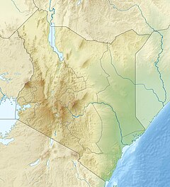
The Obi-Rakhmat Grotto is a Middle Paleolithic prehistoric site that yielded Neanderthal fossils. It is a shallow karst cave near the junction of the Chatkal and Pskem Rivers at the southwestern end of the Talassky Alatau Range in the Tien Shan Mountains, 100 km (62 mi) northeast of Tashkent, Uzbekistan.

<span class="mw-page-title-main">Betal Rock Shelter</span> Cave and archaeological site in Slovenia

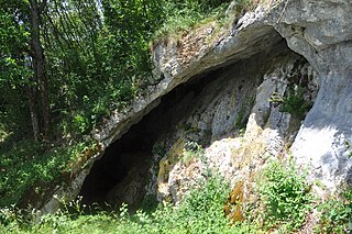
Betal Rock Shelter, a karst cave located on the south-eastern edge of the Lower Pivka river valley on a slope just above the road from Postojna to Bukovje is a site where rich cultural sediment layers with remains of stone tools, artifacts, and numerous fossilized bones of contemporary animals were found. Its entrance was formed by the collapse of the 174 m (571 ft) long cave's ceiling, carved out by the waters of the Pivka River.

Boomplaas Cave is located in the Cango Valley in the foothills of the Swartberg mountain range, north of Oudtshoorn, Eden District Municipality in the Western Cape Province, South Africa. It has a 5 m (16 ft) deep stratified archaeological sequence of human presence, occupation and hunter-gatherer/herder acculturation that might date back as far as 80,000 years. The site's documentation contributed to the reconstruction of palaeo-environments in the context of changes in climate within periods of the Late Pleistocene and the Holocene. The cave has served multiple functions during its occupation, such as a kraal (enclosure) for animals, a place for the storage of oil rich fruits and as a hunting camp. Circular stone hearths and calcified dung remains of domesticated sheep as well as stone adzes and pottery art were excavated indicating that humans lived at the site and kept animals.

Matupi Cave is a cave in the Mount Hoyo massif of the Ituri Rainforest, Democratic Republic of the Congo, where archaeologists have found evidence for Late Stone Age human occupation spanning over 40,000 years. The cave has some of the earliest evidence in the world for microlithic tool technologies.

<span class="mw-page-title-main">Kilu Cave</span> Anthropological site in Papua New Guinea

Kilu Cave is a paleoanthropological site located on Buka Island in the Autonomous Region of Bougainville, Papua New Guinea. Kilu Cave is located at the base of a limestone cliff, 65 m (213 ft) from the modern coastline. With evidence for human occupation dating back to 30,000 years, Kilu Cave is the earliest known site for human occupation in the Solomon Islands archipelago. The site is the oldest proof of paleolithic people navigating the open ocean i.e. navigating without land in sight. To travel from Nissan island to Buka requires crossing of at least 60 kilometers of open sea. The presence of paleolithic people at Buka therefore is at the same time evidence for the oldest and the longest paleolithic sea travel known so far.

<span class="mw-page-title-main">Pešturina</span> Cave and archaeological site in Serbia

Pešturina is a cave in the municipality of Niška Banja in southeast Serbia. It is located southwest of Jelašnica and 20 km (12 mi) southeast of Niš. Artifacts from the Middle and Upper Paleolithic periods were discovered since the archaeological excavations began in 2006. The remains, identified as the Mousterian culture, were dated from 111,000 BP+ 5,000 to 39,000 BP + 3,000, which makes Pešturina one of the latest surviving Neanderthal habitats. The cave has been nicknamed the "Serbian Atapuerca".

Porc-Epic Cave is an archaeological site located in Dire Dawa,Oromia, Ethiopia. Dated back to the Middle Stone Age, the site contains extensive evidence of microlithic tools, bone, and faunal remains. The lithic assemblage reveals that inhabitants at the time were well-organized with their environment. There is also rock art and strong evidence for ochre processing. The site was first discovered in 1920 by H. De Monfreid and P. Teilhard De Chardin. H. Breuil and P. Wernert performed the first excavation in 1933, followed from 1974 to 1976 by J. Desmond Clark and K.D. Williamson. Succeeding this was an excavation in 1998. Porc-Epic Cave provides insight into the behavior and technical capability of modern humans in eastern Africa during the Middle Stone Age.

<span class="mw-page-title-main">Panga ya Saidi</span> Archaeological site in Kenya

Panga ya Saidi is an archaeological cave site located in Kilifi County, southeastern Kenya, about 15 km from the Indian Ocean in the Dzitsoni limestone hills. The cave site has rich archaeological deposits dating to the Middle Stone Age, Later Stone Age, and Iron Age. Excavated deposits preserve an unusually long record of human activities, from around 78,000 years ago until around 400 years ago, a chronology supported by radiocarbon dating and optically stimulated luminescence dating. This sequence puts Panga ya Saidi alongside other key sites such as Enkapune ya Muto, Mumba Rockshelter, and Nasera Rockshelter that are important for understanding the Late Pleistocene and the Middle to Later Stone Age transition in eastern Africa.

<span class="mw-page-title-main">Mlambalasi Rock Shelter</span> National Historic Site of Tanzania

The Mlambalasi Rock Shelter is a historic site located in Iringa District of Iringa Region in southern Tanzania, 50 km away from Iringa City. Excavations in 2006 and 2010 by the Iringa Region Archaeological Project uncovered artifactual deposits from the Later Stone Age (LSA), the Iron Age, and the historic periods, as well as external artifacts from the Middle Stone Age (MSA). Direct dating on Achatina shell and ostrich eggshell beads indicates that the oldest human burials at Mlambalasi are from the terminal Pleistocene. Mlambalasi is characterized by interment in the LSA and Iron Age periods, as well as by cycles of use and abandonment.

References

  1. "Enkapune Ya Muto Rockshelter - Enkapune Ya Muto". Archaeology.about.com. Archived from the original on 3 December 2013. Retrieved 7 March 2017.
  2. 1 2 3 4 5 6 7 8 9 10 11 12 Marean, Curtis W. (1992). "Hunter to herder: large mammal remains from the hunter-gatherer occupation at Enkapune Ya Muto rock-shelter, Central Rift, Kenya". The African Archaeological Review. 10: 65–127. doi:10.1007/BF01117697. S2CID   129526564.
  3. 1 2 3 4 5 6 7 8 9 10 Ambrose, S (1997). "Chronology of the Later Stone Age and Food Production in East Africa". Journal of Archaeological Science. 25 (4): 377–392. doi:10.1006/jasc.1997.0277.