Eldoret is a principal town in the Rift Valley region of Kenya and serves as the capital of Uasin Gishu County. The town is colloquially known as 'Sisibo'. As per the 2019 Kenya Population and Housing Census, Eldoret is the fifth most populated urban area in the country after Nairobi, Mombasa, Nakuru and Ruiru. Lying south of the Cherangani Hills, the local elevation varies from about 2100 meters at the airport to more than 2700 meters in nearby areas (7000–9000 feet). The population was 289,380 in the 2009 Census, and it is currently the fastest growing town in Kenya with 475,716 people according to 2019 National Census. Eldoret is on course to be named Kenya's fourth city.

The Kalenjin are a group of Southern Nilotic tribes descending from Maliri people (thus related to Daasanach of Ethiopia.) They are indigenous to North and East Africa, residing mainly in what was formerly the Rift Valley Province in Kenya and Western slopes of Mount Elgon in Uganda. They are closely associated with Datooga of Tanzania and are thought to have interacted extensively with Iraqwi (for whom they called various names including: Sengwer, Jengwel, Chemwal, Sikker, Sirikwa and many more.) Upon their arrival in the forest region of Mau, the Kalenjin assimilated the aboriginal hunter-gatherer race known as Okiek. They number 6,358,113 individuals as per the Kenyan 2019 census and an estimated 300,000 in Uganda mainly in Kapchorwa and Bukwo districts They have been divided into 11 culturally and linguistically related tribes: Kipsigis, Nandi, Keiyo, Marakwet, Sabaot, Pokots, Tugen, Terik, Sengwer, Lembus, and Ogiek. They speak Kalenjin languages, which belong to the Nilotic language family.
The Oropom were the aboriginal inhabitants of much of Karamoja in Uganda, Mt. Elgon area and West Pokot, Trans Nzoia and Turkana regions in Kenya. Their descendants were largely assimilated into various communities present in their former territories, including the Iteso, Karamojong, Pokot, Turkana and Bukusu. They are or were found in scattered pockets between the Turkwel River, Chemorongit Mountains and Mt. Elgon. One report indicates that they formerly spoke the unclassified Oropom language.

Nakuru is a city in the Rift Valley region of Kenya. It currently serves as the capital of Nakuru County, and formerly as the capital of Rift Valley Province. As of 2019, Nakuru had an urban and rural population of 570,674 inhabitants, making it the largest urban center in the Rift Valley, with Eldoret in Uasin Gishu County following closely behind. It lies about 1,850 m above sea level.
The Marakwet are one of the groups forming the ethnolinguistic Kalenjin community of Kenya, they speak the Markweta language. The Marakwet live in five territorial sections namely Almoo, Cherangany, Endoow, Sombirir (Borokot) and Markweta. Cutting across these territorial groups are a number of clans to which each Marakwet belongs. There were 119,969 Marakwet people in 2019.

Nandi County is in the North Rift of Kenya, occupying an area of 2,884.4 square kilometres. Its capital, Kapsabet, is the largest town in the county while other towns include Mosoriot, Tinderet, Kobujoi, Kaiboi, Kabiyet and Nandi Hills. According to a 2019 census, the county had a population of 885,711, made up of a number of Kenyan communities, the majority of whom belong to the native tribe called Nandi.
Hyrax Hill is a prehistoric site near Nakuru in the Rift Valley province of Kenya. It is a rocky spur roughly half a kilometer in length, with an elevation of 1,900 meters above sea level at its summit. The site was first discovered in 1926 by Louis Leakey during excavations at the nearby Nakuru Burial Site, and Mary Leakey conducted the first major excavations between 1937 and 1938. There are two distinct areas of occupation at Hyrax Hill: one which was occupied during the Pastoral Neolithic and late Iron Age, and one which was occupied by the Sirikwa earlier in the Iron Age.
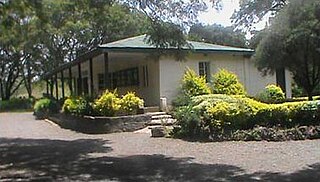
The Hyrax Hill site was proclaimed a national monument in 1945 and opened to the public in 1965. This was as a result of startling discoveries of relics by Mrs. Selfe and subsequent archaeological excavations that were carried out by Dr. Mary Leakey in 1938 that revealed substantial findings in different areas of the site and levels of occupations. The late Mrs. Selfe was the owner of the property. The renovation of archaeology exhibit was made possible through the kind sponsorship of Kenya Museum Society and consultation of British Institute in Eastern Africa in collaboration with the National Museums of Kenya. The hill comprises particular importance due to the fact that it encompasses several phases of occupation; it also has a long history of archaeological investigation, which began in 1937 with Mary Leakey.

Elgeyo-Marakwet County is one of Kenya's 47 counties. Elgeyo Marakwet County is located in the former Rift Valley Province. Its capital and largest town is Iten. It borders the counties of West Pokot to the north, Baringo County to the east, southeast and south, Uasin Gishu to the southwest and west, and Trans Nzoia to the northwest.
The Kalenjin people are an ethnolinguistic group indigenous to East Africa, with a presence, as dated by archaeology and linguistics, that goes back many centuries. Their history is therefore deeply interwoven with those of their neighboring communities as well as with the histories of Kenya, Uganda, Tanzania, South Sudan, and Ethiopia.
The Savanna Pastoral Neolithic is a collection of ancient societies that appeared in the Rift Valley of East Africa and surrounding areas during a time period known as the Pastoral Neolithic. They were South Cushitic speaking pastoralists who tended to bury their dead in cairns, whilst their toolkit was characterized by stone bowls, pestles, grindstones and earthenware pots.

The Elmenteitan culture was a prehistoric lithic industry and pottery tradition with a distinct pattern of land use, hunting and pastoralism that appeared and developed on the western plains of Kenya, East Africa during the Pastoral Neolithic c.3300-1200 BP. It was named by archaeologist Louis Leakey after Lake Elmenteita, a soda lake located in the Great Rift Valley, about 120 km (75 mi) northwest of Nairobi.
Sirikwa holes are saucer-shaped hollows found on hillsides in the western highlands of Kenya and in the elevated stretch of the central Rift Valley around Nakuru. These hollows, each having a diameter of 10–20 metres and an average depth of 2.4 metres, occur in groups, sometimes numbering fewer than ten and at times more than a hundred. Archaeologists believe that construction of these features may have begun in the Iron Age.
The Sengwer people are an indigenous community who primarily live in the Embobut forest in the western highlands of Kenya and in scattered pockets across Trans Nzoia, West Pokot and Elgeyo-Marakwet counties. The Sengwer are sometimes portrayed as a component of the Marakwet people but are a distinct ethnic grouping.
The Settlement of Nandi was the historical process by which the various communities that today make up the Nandi people of Kenya settled in Nandi County. It is captured in the folklore of the Nandi as a distinct process composed of a series of inward migrations by members from various Kalenjin ortinwek.
The Maliri were a people, recalled by various communities in Kenya and Uganda today, that inhabited regions on the north east of and north west borders of Uganda and Kenya respectively and later spread to regions in southern Ethiopia.
Mutai is a term used by the Maa-speaking communities of Kenya to describe a period of wars, usually triggered by disease and/or drought affecting widespread areas of the Rift Valley region of Kenya. According to Samburu and Maasai tradition, two periods of Mutai occurred during the nineteenth century. The second Mutai lasted from the 1870s to the 1890s.
Mutai is a term used by the Maa-speaking communities of Kenya to describe a period of wars, usually triggered by disease and/or drought and affecting widespread areas of the Rift Valley region of Kenya. According to Samburu and Maasai folklore, periods of Mutai occurred during the nineteenth century.
The Chemwal people were a Kalenjin-speaking society that inhabited regions of western and north-western Kenya as well as the regions around Mount Elgon at various times through to the late 19th century. The Nandi word Sekker was used by Pokot elders to describe one section of a community that occupied the Elgeyo escarpment and whose territory stretched across the Uasin Gishu plateau. This section of the community appears to have neighbored the Karamojong who referred to them as Siger, a name that derived from the Karimojong word esigirait. The most notable element of Sekker/Chemwal culture appears to have been a dangling adornment of a single cowrie shell attached to the forelock of Sekker women, at least as of the late 1700s and early 1800s.
The Siger people were a community commonly spoken of in the folklore of a number of Kenyan communities that inhabited regions of northwestern Kenya at various points in history.