Minori Cave

Last updated
Minori Cave
Philippines relief location map (square).svg
Red pog.svg
Location in the Philippines
Location Peñablanca, Cagayan
Philippines
Coordinates 17°43′17″N121°49′42″E / 17.72139°N 121.82833°E / 17.72139; 121.82833 Coordinates: 17°43′17″N121°49′42″E / 17.72139°N 121.82833°E / 17.72139; 121.82833
Length147 m (482.3 ft)
Elevation200 m (656.2 ft) meters above sea level
GeologyLimestone formation [1]
EntrancesTwo
FeaturesDivided into four chambers
Width7-11 meters

Minori Cave is part of the Callao limestone formation, located in Barangay Quibal, Municipality of Peñablanca, Cagayan Province in Northern Luzon. The said cave has two openings. One, designated as Mouth B, is located at 17° 43' 17" N latitude and 121° 49' 42" E longitude. The other opening, Mouth A is located 17° 43' 21" N latitude and 121° 49' 44" E longitude. The cave has an average elevation of about 200 m (656.2 ft) above sea level, and length and width of 147 m (482.3 ft) and 7 to 11 m (23.0 to 36.1 ft), respectively. The cave is divided into four chambers with mouth A as chamber A and mouth B as chamber D. Chambers B and C are in between the two mouths.

Callao Cave Cave and archaeological site in the Philippines

Callao Cave is one of the limestone caves located in the municipality of Peñablanca, Cagayan province, in the Philippines. The seven-chamber show cave is one of 300 caves that dot the area and the best known natural tourist attraction of the province. The town is named as Peñablanca for the presence of white limestone rocks in the area. Callao Cave is located in the Barangays of Magdalo and Quibal in Peñablanca about 24 km (15 mi) northeast of Tuguegarao City, the capital of the Province of Cagayan.

Cagayan Province in Cagayan Valley, Philippines

Cagayán is a province of the Philippines in the Cagayan Valley region in the northeast of Luzon Island, and includes the Babuyan Islands to the north. The province borders Ilocos Norte and Apayao to the west, and Kalinga and Isabela to the south. Its capital is the city of Tuguegarao.

Contents

Archaeological Findings

The Cagayan Valley Archaeological Project

The Cagayan Valley Archaeological Project was part of a series of archaeological expedition led by anthropologist Robert Fox in 1971 to search for the evidence of the early humans (now the Tabon Man) in the Philippines. Since then, the expedition focused more on the archaeological finds from different individual sites that were found during the expedition. This includes the slopes of the Cagayan Valley, revealing 54 sites rich in a variety of artefacts like paleolithic tools and remains. Some of the major cave sites that were discovered are the famous Callao Cave, Musang Cave, Rabel Cave and the Minori Cave, most of them are part of the Callao limestone formation. The great potential to find important artefacts in Cagayan led to the initiation of The Cagayan Valley Archaeological Project. From 1976 to 1982, 93 caves were already explored and 52 of which housed a variety of archaeological finds.

Robert Bradford Fox (1918–1985) was an anthropologist and leading historian on the prehispanic Philippines.

Tabon Man Oldest Homo sapiens fossil ever found in the Philippines

Tabon Man refers to remains discovered in the Tabon Caves in Lipuun Point in Quezon, Palawan in the Philippines. These were discovered by Robert B. Fox, an American anthropologist of the National Museum of the Philippines, on May 28, 1962. These remains, the fossilized fragments of a skull and jawbone of three individuals, were believed to be the earliest human remains known in the Philippines which date back to 16,500 years ago, until a metatarsal from the Callao Man discovered in 2007 was dated in 2010 by uranium-series dating as being 67,000 years old. The Tabon fragments are collectively called "Tabon Man" after the Tabon Cave, the place where they were found on the west coast of Palawan. Tabon Cave appears to be a kind of Stone Age factory, with both finished stone flake tools and waste core flakes having been found at four separate levels in the main chamber. Charcoal left from three assemblages of cooking fires there has been Carbon-14-dated to roughly 7000, 20,000, and 22,000 BCE.

1981 Excavation

From March to October 1981, the National Museum of the Philippines conducted archaeological excavations in the chamber D of Minori Cave. The 1981 team was able to retrieve a number of artifacts such as chert flake tools, chips, chunks, waste flakes and core as well as andesite flake tools, chips, chunks, cobble tools, waste flakes and earthenware potteries. There were also ecofacts recovered such animal bone fragments and teeth, shells and seeds. Listed below are the faunal remains found in Chamber D of the cave.

National Museum of the Philippines

The National Museum of the Philippines is an umbrella government organization that oversees a number of national museums in the Philippines including ethnographic, anthropological, archaeological and visual arts collections. Since 1998, the National Museum has been the regulatory and enforcement agency of the Government of the Philippines in the restoring and safeguarding of important cultural properties, sites, and reservations throughout the Philippines.

Andesite An intermediate volcanic rock

Andesite ( or ) is an extrusive igneous, volcanic rock, of intermediate composition, with aphanitic to porphyritic texture. In a general sense, it is the intermediate type between basalt and rhyolite, and ranges from 57 to 63% silicon dioxide (SiO2) as illustrated in TAS diagrams. The mineral assemblage is typically dominated by plagioclase plus pyroxene or hornblende. Magnetite, zircon, apatite, ilmenite, biotite, and garnet are common accessory minerals. Alkali feldspar may be present in minor amounts. The quartz-feldspar abundances in andesite and other volcanic rocks are illustrated in QAPF diagrams.

ClassificationNo. of SpecimensClassificationNo. of Specimens
Cervus sp.281Macaderma s. spasma3
Rodentia483Sus sp.97
Rattus sp.315Carnivora12
Mus sp.3Feloidea2
Macapa sp.15Squamata13
Aves9Varanus sp.2
Bat6Fish1

In chamber A, lithic implements(made of andesite and chert), earthenware and porcelain shreds, animal bone fragments, shells, lead and iron implements were found. According to Orogo(1982: no pagination), "the majority of shreds recovered were body portions of probably a vessel. The distinctive traces and marks on the earthenware were evidence that the earthenware were used for food storage.

1999 Re-excavation of Minori Cave, Chamber D

The Minori Cave's chamber D was re-excavated in the year 1999. This time, the team used a spit system of excavation. Upon the analysis of vertical distribution of the recovered artifacts, two cultural horizons were identified; the uppermost, Cultural Layer II, contained both flakes, tools and ceramics, while Cultural Layer I contained a stratigraphically older assemblage of archaeological materials including stone tools but no ceramics. The team have been able to date a charcoal sample from an upper spit. The date was 4,590 years BP+/- 50. This effectively dated Cultural Layer II to the ceramic period.

Conclusions

The Minori Cave flake samples were analyzed. The morphological attributes of the flakes, the completeness of the flakes, the shapes and scars on the flakes were recorded. The findings on the andesite flakes were then compared to chert flakes. According to the findings, the prehistoric people from the region were utilizing chert flakes regardless of size. The people are maximizing the use of the particular resource(chert), which is not as common as andesite in the area. The prehistoric people who were making and using these flakes in Minori Cave, were probably aware of the efficiency of chert in the form of flake tools. Although many andesite flakes found in the archaeological assemblages in Minori cave, less than half of the total andesite flakes collected displayed polish and striations. Base from the observations, the study of the stone tools (andesite and chert) has proven that the andesite tools were functionally tools, although they may not as efficient as chert flakes. This study is also an evidence that an expedient technology existed and persisted in Minori Cave in Northern Luzon (Philippines), as in the rest of the Southeast Asian region. The practicality of the industries is not due to cultural stagnation, but as an appropriate cultural adaptation by prehistoric people to their environment and its resources. [2]

Related Research Articles

Chert A hard, fine-grained sedimentary rock composed of crystals of quartz (silica) that are very small

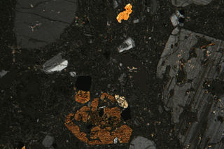
Chert is a hard, fine-grained sedimentary rock composed of crystals of quartz (silica) that are very small (microcrystalline or cryptocrystalline). Quartz (silica) is the mineral form of silicon dioxide (SiO2). Chert is often of biological origin (organic) but may also occur inorganically as a chemical precipitate or a diagenetic replacement (e.g., petrified wood). Geologists use chert as a generic name for any type of microcrystalline or cryptocrystalline quartz.

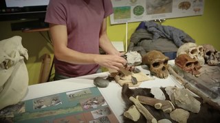
In archaeology, lithic analysis is the analysis of stone tools and other chipped stone artifacts using basic scientific techniques. At its most basic level, lithic analyses involve an analysis of the artifact’s morphology, the measurement of various physical attributes, and examining other visible features.

Industry (archaeology) Typological classification of stone tools

In the archaeology of the Stone Age, an industry or technocomplex is a typological classification of stone tools. It is not to be confused with industrial archaeology, which concentrates on industrial sites from more recent periods.

Blade (archaeology) type of stone tool

In archaeology, a blade is a type of stone tool created by striking a long narrow flake from a stone core. This process of reducing the stone and producing the blades is called lithic reduction. Archaeologists use this process of flintknapping to analyze blades and observe their technological uses for historical peoples.

The term Hòa Bình culture was first used by French archaeologists working in Northern Vietnam to describe Holocene period archaeological assemblages excavated from rock shelters. The related English adjective Hoabinhian has become a common term in the English-based literature to describe stone artifact assemblages in Southeast Asia that contain flaked, cobble artifacts, dated to c. 10,000–2000 BCE. The term was originally used to refer to a specific ethnic group, restricted to a limited period with a distinctive subsistence economy and technology. More recent work uses the term to refer to artifacts and assemblages with certain formal characteristics.

Fuga Island island in the Philippines

Fuga Island is an island north of Luzon, part of the Babuyan Archipelago, which is the second-northernmost island group of the Philippines. It has an area of 100 square kilometres (39 sq mi) and a population of 2,015 persons. The principal settlement is Naguilian (Musa) village on the southern coast. The highest peak is Mount Nanguringan in the northeast, with an elevation of 191 metres (627 ft).

Debitage

Debitage is all the material produced during the process of lithic reduction and the production of chipped stone tools. This assemblage includes, but is not limited to, different kinds of lithic flakes and lithic blades, shatter and production debris, and production rejects.

Bann flake

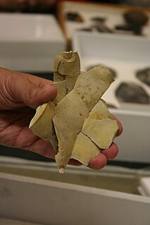
A Bann flake is a large, butt-trimmed, leaf-shaped lithic blade of flint or chert, dating from the Late Mesolithic period of prehistoric Ireland, from around 4500 BC onwards. They are named after the river Bann in Northern Ireland where large numbers have been found. The term is rather variably defined, and the uses of the flakes probably varied considerably, with many being all-purpose tools, and perhaps weapons. Some were probably used as spear heads attached to wooden shafts, despite many being rather heavy for this.

Buttermilk Creek Complex Place in Texas, United States

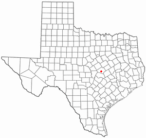
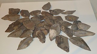
Buttermilk Creek Complex refers to the remains of a paleolithic settlement along the shores of Buttermilk Creek in present-day Salado, Texas dated to approximately 15,500 years old. If confirmed, the site represents evidence of human settlement in the Americas that pre-dates the Clovis culture.

Hazar Merd Cave Group of Paleolithic cave sites excavated by Dorothy Garrod in 1928

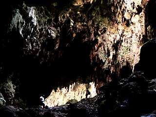
Hazar Merd is a group of Paleolithic cave sites excavated by Dorothy Garrod in 1928. The caves are located south-southwest of Sulaymaniyah in Sulaymaniyah Governorate in Iraq. Garrod's soundings in two caves in the Hazar Merd group provided evidence of Middle and Epi-Paleolithic occupation.The Dark cave or Ashkawty Tarik in Kurdish has a commanding view of the local valley and is close to a small spring and a village with the same name.

Franktown Cave archaelogical site in Colorado, United States

Franktown Cave is located 25 miles south of Denver, Colorado on the north edge of the Palmer Divide. It is the largest rock shelter documented on the Palmer Divide, which contains artifacts from many prehistoric cultures. Prehistoric hunter-gatherers occupied Franktown Cave intermittently for 8000 years beginning about 6400 B.C. The site held remarkable lithic and ceramic artifacts, but it is better known for its perishable artifacts, including animal hides, wood, fiber and corn. Material goods were produced for their comfort, task-simplification and religious celebration. There is evidence of the site being a campsite or dwelling as recent as AD 1725.

New Guinea II cave Rock shelter and archaeological site in Australia

New Guinea II is a limestone cave and rockshelter on the Snowy River at the end of New Guinea Track, near Buchan, Victoria. The cave was within the country of the Krowathunkooloong clan of the Gunaikurnai nation. The deep cave system has an overhanging cliff that creates a rock shelter at the entrance facing the river. Excavations in the 1980s carried out by archaeologist Paul Ossa and a team from LaTrobe University found stone artefacts, and other signs of occupation that were dated to almost 20,000 BP.

Dewil Valley, located in the northernmost part of Palawan, an island province of the Philippines that is located in the MIMAROPA region, is an archaeological site composed of thousands of artifacts and features. According to the University of the Philippines Archaeological Studies Program, or UP-ASP, the closest settlement can be found in New Ibajay, which is covered by the town capital of El Nido, which is located around 9 km (5.6 mi) south-east of Dewil Valley. Physically it measures around 7 km (4.3 mi) long, and 4 km (2.5 mi) wide. It is in this place which the Ille Cave, one of the main archaeological sites, can be found. It is actually a network of 3 cave mouths located at its base. It has been discovered that this site in particular has been used and occupied by humans over multiple time periods.

Misamis Oriental can be found in Northern Mindanao, Philippines. It is divided into twenty-three municipalities and two main cities. Its capital, Cagayan de Oro, is an urbanized location and independently governs itself from Misamis Oriental.

Lapuz Lapuz Cave Cave and archaeological site in the Philippines

Lapuz Lapuz Cave is among the many cave sites found in the Bulabog Putian National Park in Moroboro, Dingle, Iloilo in the Philippines. It is 90 m (295.3 ft) long and light reaches up to within 30 m (98.4 ft) from each of its two entrances. The limestone area at its south end is adjacent to Jalaur River, while the north side is adjacent to the Tambunac River.

Kilu Cave

Kilu Cave is a paleoanthropological site located on Buka Island in the Autonomous Region of Bougainville, Papua New Guinea. Kilu Cave is located at the base of a limestone cliff, 65 m (213 ft) from the modern coastline. With evidence for human occupation dating back to 29,000 years, Kilu Cave is the earliest known site for human occupation in the Solomon Islands archipelago.

Belderrig (archaeological site)

Belderrig is a small village on the North Mayo coast, and lies within the Céide Fields complex, a prehistoric landscape of field systems and related domestic and ritual structures dating to the Neolithic and Bronze Age. The excavations at Belderrig were initiated by Graeme Warren, School of Archaeology, University College Dublin, Ireland, after visiting the site in 2003 with its discoverer, the archaeologist Seamas Caulfield.

Nwya Devu

Nwya Devu is a high-altitude archaeological site on the Tibetan Plateau located in the eastern Changtang region of Tibet. At around 4,600 m (15,092 ft) above sea level, Nwya Devu is the highest known archaeological site from the Paleolithic and provides evidence for the earliest known presence of humans at a high-altitude site, at around 40,000-30,000 BP.

References

  1. Guillermo, Artemio R. (2012). "Historical Dictionary of the Philippines, 3rd edition", pg. 125. Scarecrow Press, Inc., Maryland.
  2. Mijares, A. (2002). The Minori Cave Expedient Lithic Technology. Diliman, Quezon City: University of the Philippines Press.