Related Research Articles
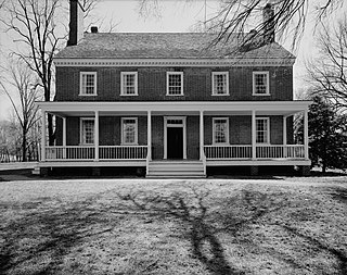
Historic Locust Grove is a 55-acre 18th-century farm site and National Historic Landmark situated in eastern Jefferson County, Kentucky in what is now Louisville. The site is owned by the Louisville Metro government, and operated as a historic interpretive site by Historic Locust Grove, Inc.
The Ake Site is a name for a prehistoric archaeological location near the town of Datil in the San Augustine Basin of Catron County, New Mexico, United States. It was listed on the New Mexico Register of Cultural Properties in 1975, and listed on the National Register of Historic Places in 1976. The Ake Site is particularly important for the age and length of its use by prehistoric peoples. It has been dated during the Clovis period between 10,999 BC and 8000 BC, and during the Folsom period between 7999 BC and 5999 BC, making it among the oldest sites in the American Southwest.

The Union Monument in Louisville is located in Cave Hill Cemetery in Louisville, Kentucky. It was built in 1914 from granite, honoring unknown soldiers who fought in the Union during the American Civil War. It is in front of the large number of Union soldiers buried at Cave Hill.

Obsidian Cliff, also known as 48YE433, was an important source of lithic materials for prehistoric peoples in Yellowstone National Park near Mammoth Hot Springs, Wyoming, United States. The cliff was named by Philetus Norris, the second park superintendent in 1878. It was declared a National Historic Landmark in 1996.

Danger Cave is a North American archaeological site located in the Bonneville Basin of western Utah around the Great Salt Lakes region, that features artifacts of the Desert Culture from c. 9000 BC until c. 500 AD. Through carbon-14 dating, it has been determined that there is very little evidence of human life in the Danger Cave area c. 11,000 BP [9000 BC], but there is much evidence of human life by 9000 BP [7000 BC].
The Bull Thistle Cave Archaeological Site is an archaeological site on the National Register of Historic Places, located in Tazewell County, Virginia. It is a vertical shaft pit burial cave. The distribution of the skeletal remains indicates that bodies were either thrown or lowered into the cave. On the surface of the cave floor, researchers have discovered the remains of a minimum of 11 bodies. Based on an artifact recovered from the site, it is estimated that the cave was used for burials between 1300 and 1600 AD.

The Windust Caves (45-FR-46) are a series of nine caves eroded into a basalt cliff on the north side of the lower Snake River in Franklin County, southeastern Washington. The caves were excavated from 1959 until 1961 by a crew led by Harvey S. Rice. The site contains cultural artifacts dating back over 10,000 years and is culturally associated with other sites in the Columbia Basin.

This is a list of the National Register of Historic Places listings in Logan County, Kentucky.
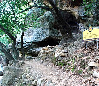
Chumash Painted Cave State Historic Park is a unit in the state park system of California, preserving a small sandstone cave adorned with rock art attributed to the Chumash people. Adjoining the small community of Painted Cave, the site is located about 2 miles (3.2 km) north of California State Route 154 and 11 miles (18 km) northwest of Santa Barbara. The 7.5-acre (3.0 ha) park was established in 1976.

This is a list of the National Register of Historic Places listings in Androscoggin County, Maine.

This is a list of the National Register of Historic Places listings in Hancock County, Maine.
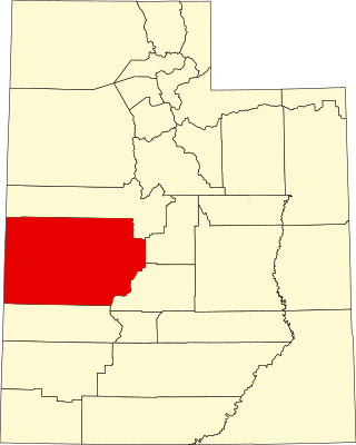
This is a list of the National Register of Historic Places listings in Millard County, Utah.

This is a list of the National Register of Historic Places listings in Roger Mills County, Oklahoma.

This is a list of the National Register of Historic Places listings in Pope County, Minnesota. It is intended to be a complete list of the properties and districts on the National Register of Historic Places in Pope County, Minnesota, United States. The locations of National Register properties and districts for which the latitude and longitude coordinates are included below, may be seen in an online map.
This is a list of the National Register of Historic Places listings in Koochiching County, Minnesota. It is intended to be a complete list of the properties and districts on the National Register of Historic Places in Koochiching County, Minnesota, United States. The locations of National Register properties and districts for which the latitude and longitude coordinates are included below, may be seen in an online map.

This is a list of the National Register of Historic Places listings in Mower County, Minnesota. It is intended to be a complete list of the properties and districts on the National Register of Historic Places in Mower County, Minnesota, United States. The locations of National Register properties and districts for which the latitude and longitude coordinates are included below, may be seen in an online map.
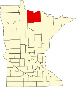
This is a list of the National Register of Historic Places listings in Voyageurs National Park.
The LaGrange Rock Shelter is an archaeological site located on private property between Leighton and Muscle Shoals in Colbert County, Alabama, near the original campus of LaGrange College. The shelter measures 70 feet long by 15 feet deep and is located beneath a sandstone outcrop overlooking a dense series of Paleoindian sites in the valley below, which may have led to it being chosen for excavation.
The Talagi Pictograph Cave is a rock art site on the island of Guam. It is located on property owned by the government of Guam within the bounds of Andersen Air Force Base on the northern part of the island near Tarague Beach. The cave contains thirteen pictographs representing human figures, and a places where limestone mortar was used that is of prehistoric origin. Based on the characteristics of the figures, it is believed that they were probably the work of a single individual. It is one of a small number known rock art sites on the island.

Gadao's Cave, also known as Liyang Gadao, is a rock art site on the United States island of Guam. Located near the village of Inarajan, the cave is the site of a panel of approximately 50 Chamorro pictographs, painted with a mixture of coral lime and tree sap. The most unusual images are of two human stick figures that appear to be carrying things. It is not known who painted them or when, and what their significance is. The legendary chief of Inarajan Gadao is believed to be the creator of the cave's images.
References
- 1 2 "National Register Information System". National Register of Historic Places . National Park Service. July 9, 2010.
- ↑ Smith, Geoffrey M.; Kielhofer, Jennifer (2011). "Through the High Rock and Beyond: Placing the Last Supper Cave and Parman Paleoindian Lithic Assemblages into a Regional Context" (PDF). 38. Journal of Archaeological Science: 3568–3576. Retrieved June 19, 2016.
{{cite journal}}: Cite journal requires|journal=(help)
| | This article about a property in Nevada on the National Register of Historic Places is a stub. You can help Wikipedia by expanding it. |