Morgan County, West Virginia

Last updated

Morgan County
Morgan County Courthouse Complex Jul 11.JPG
Morgan County Courthouse Complex, July 2011
Flag of Morgan County, West Virginia.svg
Map of West Virginia highlighting Morgan County.svg
Location within the U.S. state of West Virginia
West Virginia in United States.svg
West Virginia's location within the U.S.
Coordinates: 39°34′N78°16′W / 39.56°N 78.26°W / 39.56; -78.26
CountryFlag of the United States.svg United States
StateFlag of West Virginia.svg  West Virginia
FoundedFebruary 9, 1820
Named for Daniel Morgan
Seat Berkeley Springs
Largest townBerkeley Springs
Area
  Total230 sq mi (600 km2)
  Land229 sq mi (590 km2)
  Water0.5 sq mi (1 km2)  0.2%
Population
 (2020)
  Total17,063
  Estimate 
(2021)
17,221 Increase2.svg
  Density74/sq mi (29/km2)
Time zone UTC−5 (Eastern)
  Summer (DST) UTC−4 (EDT)
Congressional district 2nd
Website www.morgancountywv.gov

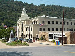
Morgan County is a county located in the U.S. state of West Virginia. As of the 2020 census, the population was 17,063. [1] Its county seat is Berkeley Springs. [2] The county was formed in 1820 from parts of Hampshire and Berkeley Counties and named in honor of General Daniel Morgan, prominent soldier of the American Revolutionary War. [3] The county and town of Bath are considered an excellent jumping off point for exploring the Potomac and Cacapon Rivers valleys just to the north and west. Along with also being a tourist destination hosting numerous local artists, mineral water spas, and a large amount of outdoor recreation that includes fishing, boating, wildlife, hunting, and mountain scenery. The region is known for the famed Apple Butter Festival held annually in October. Morgan County is also the home of an important silica mine, part of U.S. Silica. [4]

Contents

History

Morgan County was created by an act of the Virginia General Assembly in February 1820 from parts of Berkeley and Hampshire counties. It was named in honor of General Daniel Morgan (1736–1802). He was born in Hunterdon County, New Jersey, and moved to Winchester, Virginia as a youth. He served as a wagoner in Braddock's Army during the campaign against the Native Americans in 1755. During the campaign, a British Lieutenant became angry with him and hit him with the flat of his sword. Morgan punched the Lieutenant, knocking him unconscious. Morgan was court-martialed for striking a British officer and was sentenced to 500 lashes. Morgan later joked that the drummer who counted out the lashes miscounted and he received only 499 lashes. For the rest of his life he claimed the British still owed him one.

Early European settlers

The first English settlers in present-day Morgan County arrived during the 1730s. Because most of these early pioneers were squatters, there is no record of their names. Historians claim that the first cabin in the county was built around 1745. As word of the county's warm springs spread eastward, Thomas Fairfax, 6th Lord Fairfax of Cameron decided that the county needed to be surveyed. In 1748, George Washington, then just 16 years old, was part of the survey party that surveyed the Eastern Panhandle region for Lord Fairfax. He later returned to Bath (Berkeley Springs) several times over the next several years with his half-brother, Lawrence, who was ill and hoped that the warm springs might improve his health. The springs, and their rumored medicinal benefits, attracted numerous Native Americans as well as Europeans to the area.

18th century

As mentioned previously, George Washington visited present-day Berkeley Springs several times with his half-brother, Lawrence. When he vacationed in the area in 1767, he noted how busy the town had become. Lord Fairfax had built a summer home there and a "private bath" making the area a popular destination for Virginia's social elite. As the town continued to grow, the Virginia General Assembly decided to formally recognize it. In October 1776, the town was officially named Bath, in honor of England's spa city called Bath. The town's main north–south street was named Washington and the main east–west street was named Fairfax. Also, seven acres (28,000 m2) were set aside for "suffering humanity." When West Virginia gained statehood, that area became West Virginia's first state park.

Bath's population increased during and immediately after the American Revolutionary War as wounded soldiers and others came to the area believing that the warm springs had medicinal qualities. Bath gained a reputation as a somewhat wild town where eating, drinking, dancing, and gambling on the daily horse races were the order of the day.

Bath later became known as Berkeley Springs, primarily because the town's post office took that name (combining Governor Norborne Berkeley's last name with the warm springs found there) to avoid confusion with another post office, located in southeastern Virginia, which was already called Bath. Because the mail was sent to and from Berkeley Springs, that name slowly took precedence.

19th century

Morgan County was one of fifty Virginia counties that were admitted to the Union as the state of West Virginia on June 20, 1863. Later that year, the counties were divided into civil townships, with the intention of encouraging local government. This proved impractical in the heavily rural state, and in 1872 the townships were converted into magisterial districts. [5] Morgan County was divided into six districts: Allen, Bath, Cacapon, [lower-roman 1] Rock Gap, Sleepy Creek, and Timber Ridge. Except for minor adjustments, the historic magisterial districts remained unchanged until the 1980s, when they were consolidated into three new districts: District 1, District 2, and District 3. A District 4 was created in the 1990s, but subsequently discontinued. [6]

20th century

On April 10, 1919, racial violence broke out when the Morgan County race riot was sparked by local business using African-American strikebreakers against local striking white workers. [7] On the same day of the riots one Hugh Ferguson, a Martinsburg African-American, was accused of criminally assaulting Mrs. Ernest Zimmerman at her home near Brosius, Morgan County (now known as Hancock, West Virginia). An angry mob of several hundred men formed around the jail hoping to lynch Ferguson. Sheriff C. R. Hovermale was forced to flee town with Ferguson. [8]

Geography

According to the United States Census Bureau, the county has a total area of 230 square miles (600 km2), of which 229 square miles (590 km2) is land and 0.5 square miles (1.3 km2) (0.2%) is water. [9]

Major highways

Adjacent counties

Rivers and streams

Demographics

Historical population
CensusPop.Note
1820 2,500
1830 2,6947.8%
1840 4,25357.9%
1850 3,557−16.4%
1860 3,7324.9%
1870 4,31515.6%
1880 5,77733.9%
1890 6,74416.7%
1900 7,2948.2%
1910 7,8487.6%
1920 8,3576.5%
1930 8,4060.6%
1940 8,7434.0%
1950 8,276−5.3%
1960 8,3761.2%
1970 8,5472.0%
1980 10,71125.3%
1990 12,12813.2%
2000 14,94323.2%
2010 17,54117.4%
2020 17,063−2.7%
2021 (est.)17,221 [10] 0.9%
U.S. Decennial Census [11]
1790–1960 [12] 1900–1990 [13]
1990–2000 [14] 2010-2020 [1]

2020 census

As of the 2020 census, there were 17,063 people and 6,957 households residing in the county. There were 9,071 housing units in Morgan. The racial makeup of the county was 93.7% White, 0.7% African American, 0.5% Asian, 0.2% Native American, 0.5% from other races, and 4.5% from two or more races.Hispanics or Latinos of any race were 1.4% of the population.

Of the 6,957 households, 56.4% were married couples living together, 19.9% had a female householder with no spouse present, 16.1% had a male householder with no spouse present. The average household and family size was 2.93. The median age in the county was 48.5 years with 17.7% of the population under 18. The median income for a household was $56,616 and the poverty rate was 8%. [15]

2010 census

As of the 2010 United States census, there were 17,541 people, 7,303 households, and 5,015 families living in the county. [16] The population density was 76.6 inhabitants per square mile (29.6/km2). There were 9,753 housing units at an average density of 42.6 per square mile (16.4/km2). [17] The racial makeup of the county was 97.3% white, 0.6% black or African American, 0.3% Asian, 0.3% Native American, 0.2% from other races, and 1.3% from two or more races. Those of Hispanic or Latino origin made up 1.0% of the population. [16] In terms of ancestry, 27.0% were German, 13.2% were Irish, 11.5% were American, and 10.6% were English. [18]

Of the 7,303 households, 27.8% had children under the age of 18 living with them, 54.1% were married couples living together, 8.9% had a female householder with no husband present, 31.3% were non-families, and 25.7% of all households were made up of individuals. The average household size was 2.39 and the average family size was 2.84. The median age was 45.0 years. [16]

The median income for a household in the county was $37,281 and the median income for a family was $49,974. Males had a median income of $39,372 versus $27,949 for females. The per capita income for the county was $20,732. About 11.9% of families and 15.8% of the population were below the poverty line, including 22.0% of those under age 18 and 10.6% of those age 65 or over. [19]

2000 census

As of the census of 2000, there were 14,943 people, 6,145 households, and 4,344 families living in the county. The population density was 65 inhabitants per square mile (25/km2). There were 8,076 housing units at an average density of 35 per square mile (14/km2). The racial makeup of the county was 98.30% White, 0.60% Black or African American, 0.17% Native American, 0.12% Asian, 0.01% Pacific Islander, 0.23% from other races, and 0.57% from two or more races. 0.83% of the population were Hispanic or Latino of any race.

There were 6,145 households, out of which 28.70% had children under the age of 18 living with them, 57.90% were married couples living together, 8.20% had a female householder with no husband present, and 29.30% were non-families. 24.50% of all households were made up of individuals, and 10.20% had someone living alone who was 65 years of age or older. The average household size was 2.40 and the average family size was 2.84.

The age distribution is 22.40% under the age of 18, 6.80% from 18 to 24, 27.30% from 25 to 44, 26.90% from 45 to 64, and 16.60% who were 65 years of age or older. The median age was 41 years. For every 100 females there were 96.60 males. For every 100 females age 18 and over, there were 95.00 males.

The median income for a household in the county was $35,016, and the median income for a family was $40,690. Males had a median income of $29,816 versus $22,307 for females. The per capita income for the county was $18,109. About 8.00% of families and 10.40% of the population were below the poverty line, including 11.60% of those under age 18 and 8.80% of those age 65 or over.

Government and Public Safety

County government

Morgan County Commission is a three-member elective body. The term of office for each Commission member is six years, with one term expiring every two years. The current commissioners are Sean Forney - President, Joel Tuttle -Commissioner, and Bill Clark - Commissioner

County Sheriff

The Morgan County Sheriff's Office operates the county jail, provides court protection, provides county building and facility security, and provides patrol and detective services for the county. The current sheriff is K.C. Bohrer after being re-elected for his second term.

County Clerk

The current county clerk is Kimberly Nickles

County Assessor

The current assessor is Debbie Weaver

Magistrates

Morgan County has two Magistrates: Kermit Ambrose and Greg Miller

Politics

Morgan County has historically been a stronghold for the Republican Party. Every Republican presidential nominee has won Morgan County since 1864, the first presidential election following West Virginia's statehood. The last Democratic presidential nominee to win Morgan County was Lewis Cass in 1848; the county was won by the Whig Party, the Know-Nothing Party and John Bell’s Constitutional Union Party in its last three elections as part of Virginia.

United States presidential election results for Morgan County, West Virginia [20]
Year Republican Democratic Third party
No.%No.%No.%
2020 6,53775.17%1,99822.98%1611.85%
2016 5,73274.09%1,57320.33%4325.58%
2012 4,51363.82%2,36333.42%1952.76%
2008 4,42860.86%2,72137.40%1271.75%
2004 4,51165.88%2,27233.18%640.93%
2000 3,63963.05%1,93933.59%1943.36%
1996 2,59951.16%1,92937.97%55210.87%
1992 2,58548.37%1,85434.69%90516.93%
1988 3,00265.78%1,54533.85%170.37%
1984 3,46970.34%1,45729.54%60.12%
1980 2,83361.23%1,59434.45%2004.32%
1976 2,36955.12%1,92944.88%00.00%
1972 3,01472.94%1,11827.06%00.00%
1968 2,24460.32%1,01527.28%46112.39%
1964 1,86650.62%1,82049.38%00.00%
1960 2,75266.78%1,36933.22%00.00%
1956 2,94672.74%1,10427.26%00.00%
1952 2,69970.78%1,11429.22%00.00%
1948 2,15966.09%1,10433.79%40.12%
1944 2,30372.01%89527.99%00.00%
1940 2,56366.59%1,28633.41%00.00%
1936 2,55561.07%1,62038.72%90.22%
1932 2,08259.78%1,35838.99%431.23%
1928 2,53976.75%75822.91%110.33%
1924 1,88363.10%91930.80%1826.10%
1920 1,81771.48%71228.01%130.51%
1916 1,20863.45%66634.98%301.58%
1912 61234.89%54931.30%59333.81%

Communities

Sunset over Morgan County, West Virginia Sunset over Morgan County, West Virginia.JPG
Sunset over Morgan County, West Virginia

Towns

Magisterial districts

Current

  • District 1
  • District 2
  • District 3

Historic

  • Allen
  • Bath
  • Cacapon
  • Rock Gap
  • Sleepy Creek
  • Timber Ridge
  • District 4

Census-designated places

Unincorporated communities

Historic Places

The following are listed on the National Register of Historic Places:

SiteYear BuiltAddressCommunityListed
Ambrose Chapel mid-19th centuryWinchester Grade Road (CR 13) Stotlers Crossroads 1998
Berkeley Springs State Park mid-18th centurySouth Washington & Fairfax Streets Berkeley Springs 1976
Berkeley Springs Train Depot 1900–1924342 North Washington Street (US 522) Berkeley Springs 2001
Chesapeake and Ohio Canal National Historical Park early 19th centuryChesapeake & Ohio Canal Paw Paw 1966
Clarence Hovermale House (Allen Mendenhall House)late 19th century167 Wilkes Street Berkeley Springs 2003
John Herbert Quick House (Coolfont Manor House)191373 Manor House Lane Berkeley Springs 1984
Judge John W. Wright Cottage 1872156 South Green Street Berkeley Springs 1986
New Deal Resources in Cacapon State Park Historic District 1934818 Cacapon Lodge Drive Berkeley Springs 2019
Morgan County Courthouse 1923202 Fairfax Street (CR 9/9) Berkeley Springs 2005
Samuel Taylor Suit Cottage (Berkeley Castle)1885276 Cacapon Road (WV 9) Berkeley Springs 1980
Sloat-Horn-Rossell House (The Manor)late 19th century234 Fairfax Street (CR 9/9) Berkeley Springs 1984
T. H. B. Dawson House 1880139 South Green Street Berkeley Springs 1983
Town of Bath Historic District 1776-1959Center roughly intersection of Fairfax St and Washington St Berkeley Springs 2009
Paw Paw Old Mayor's Office and Jail 189393 Lee St Paw Paw 2023
Saint Charles Catholic Mission Church 1876153 Winchester St Paw Paw,2024
Western Maryland Railroad Right-of-Way, Milepost 126 to Milepost 160 20th centuryMilepost 126 to Milepost 160 Jerome 1981

See also

Footnotes

  1. Also called "Great Cacapon" before 1900.

Related Research Articles

<span class="mw-page-title-main">Frederick County, Virginia</span> County in Virginia, United States

Frederick County is located in the Commonwealth of Virginia. As of the 2020 census, the population was 91,419. Its county seat is Winchester. The county was formed in 1743 by the splitting of Orange County. It is Virginia's northernmost county. Frederick County is included in the Winchester, VA-WV Metropolitan Statistical Area, which is also included in the Washington-Baltimore-Northern Virginia, DC-MD-VA-WV-PA Combined Statistical Area.

<span class="mw-page-title-main">Ohio County, West Virginia</span> County in West Virginia, United States

Ohio County is a county located in the Northern Panhandle of the U.S. state of West Virginia. As of the 2020 census, the population was 42,425. Its county seat is Wheeling. The county was formed in 1776 from the District of West Augusta, Virginia. It was named for the Ohio River, which forms its western boundary with the state of Ohio. West Liberty was designated as the county seat in 1777, serving to 1797.

<span class="mw-page-title-main">Morgan County, Alabama</span> County in Alabama, United States

Morgan County is a county in the north-central part of the U.S. state of Alabama. As of the 2020 census, its population was 123,421. The county seat is Decatur. On June 14, 1821, it was renamed in honor of American Revolutionary War General Daniel Morgan of Virginia. It is a prohibition or dry county, although alcohol sales are allowed in the cities of Decatur, Hartselle, and Priceville. Morgan County is included in the Decatur, AL Metropolitan Statistical Area, which is also included in the Huntsville-Decatur-Albertville, AL Combined Statistical Area. It is a part of the North, Northwest, and North-Central regions of Alabama.

<span class="mw-page-title-main">Tucker County, West Virginia</span> County in West Virginia, United States

Tucker County is a county in the U.S. state of West Virginia. As of the 2020 census, the population was 6,762, making it West Virginia's fourth-least populous county. Its county seat is Parsons. The county was created in 1856 from a part of Randolph County, then part of Virginia. In 1871, a small part of Barbour County, was transferred to Tucker County. The county was named after Henry St. George Tucker, Sr., a judge and Congressman from Williamsburg, Virginia.

<span class="mw-page-title-main">Pocahontas County, West Virginia</span> County in West Virginia, United States

Pocahontas County is a county located in the eastern part of the U.S. state of West Virginia. As of the 2020 census, the population was 7,869. Its county seat is Marlinton. The county was established in 1821. It is named after the daughter of the Powhatan chief of the Native Americans in the United States who came from Jamestown, Virginia. She married an English settler, and their children became ancestors of many of the First Families of Virginia.

<span class="mw-page-title-main">Marshall County, West Virginia</span> County in West Virginia, United States

Marshall County is a county in the U.S. state of West Virginia. At the 2020 census, the population was 30,591. Its county seat is Moundsville. With its southern border at what would be a continuation of the Mason-Dixon line to the Ohio River, it forms the base of the Northern Panhandle of West Virginia.

<span class="mw-page-title-main">Hampshire County, West Virginia</span> County in West Virginia, United States

Hampshire County is a county in the U.S. state of West Virginia. As of the 2020 census, the population was 23,093. Its county seat is Romney, West Virginia's oldest town (1762). The county was created by the Virginia General Assembly in 1754, from parts of Frederick and Augusta Counties (Virginia) and is the state's oldest county. The county lies in both West Virginia's Eastern Panhandle and Potomac Highlands regions.

<span class="mw-page-title-main">Berkeley County, West Virginia</span> County in West Virginia, United States

Berkeley County is located in the Shenandoah Valley in the eastern panhandle region of West Virginia in the United States. The county is part of the Hagerstown–Martinsburg metropolitan area. As of the 2020 census, the county population was 122,076, making it the second-most populous of West Virginia's 55 counties, behind Kanawha County. The City of Martinsburg is the county seat.

<span class="mw-page-title-main">Clarke County, Virginia</span> County in Virginia, United States

Clarke County is a county in the Commonwealth of Virginia. As of the 2020 census, the population was 14,783. Its county seat is Berryville. Clarke County is included in the Washington-Arlington-Alexandria, DC-VA-MD-WV Metropolitan Statistical Area.

<span class="mw-page-title-main">Bath County, Virginia</span> County in Virginia, United States

Bath County is a United States county on the central western border of the Commonwealth of Virginia, on the West Virginia state line. As of the 2020 census, the population was 4,209, the second-least populous county in Virginia. Bath's county seat is Warm Springs.

<span class="mw-page-title-main">Bridgeport, Ohio</span> Village in Ohio, United States

Bridgeport is a village in eastern Belmont County, Ohio, United States. It lies across the Ohio River from Wheeling, West Virginia, at the mouth of Wheeling Creek and is connected by two bridges to Wheeling Island. The population was 1,582 at the 2020 census. It is part of the Wheeling metropolitan area.

<span class="mw-page-title-main">Richhill Township, Greene County, Pennsylvania</span> Township in Pennsylvania, United States

Richhill Township is a township in Greene County, Pennsylvania, United States. The population was 773 at the 2020 census, down from 896 at the 2010 census. Ryerson Station State Park is a Pennsylvania state park on Duke Lake in the township.

<span class="mw-page-title-main">Idylwood, Virginia</span> Census-designated place in Virginia, United States

Idylwood is a census-designated place (CDP) in Fairfax County, Virginia, United States. The population was 17,954 as of the 2020 census. It originally developed as a suburban community along the route of the Washington and Old Dominion Railroad, and later along Virginia State Route 7. The construction of the Capital Beltway in the 1960s, and I-66 and the Orange Line of the Washington Metrorail system in the 1980s, as well as the concurrent development of nearby Tysons Corner into Washington's leading suburban business district, led to the development of several apartment, townhouse, and small-lot single-family housing complexes, as well as the high-rise Idylwood Towers condominium, in the portion of Idylwood lying to the north of I-66. The area to the south of I-66 remains primarily large-lot single-family.

<span class="mw-page-title-main">Lincolnia, Virginia</span> Census-designated place in Virginia, United States

Lincolnia is a census-designated place (CDP) in Fairfax County, Virginia, United States. The population was 22,828 at the 2010 census, an increase of over 44% from 2000.

<span class="mw-page-title-main">Merrifield, Virginia</span> Census-designated place in Virginia, United States

Merrifield is a census-designated place (CDP) in Fairfax County, Virginia, United States. The population was 20,488 at the 2020 census.

<span class="mw-page-title-main">Hedgesville, West Virginia</span> Town in West Virginia, United States

Hedgesville is a town in Berkeley County, West Virginia, United States, in the state's Eastern Panhandle region. The population was 318 at the 2010 census. The town sits on WV 9, roughly 13 miles east of Berkeley Springs. In addition to its legal definition, Hedgesville has come to be the common name for the large and sparsely inhabited area of West Virginia's Eastern Panhandle bordered by the Potomac River to the North and East, a southern border defined roughly by an imaginary line from the city of Martinsburg to the tip of Virginia, and Berkeley Springs to the West.

<span class="mw-page-title-main">Capon Bridge, West Virginia</span> Town in West Virginia, United States

Capon Bridge is a town in eastern Hampshire County, West Virginia, United States, along the Northwestern Turnpike, approximately 20 miles (32 km) west of Winchester, Virginia. The population was 418 at the 2020 census. Originally known as "Glencoe", Capon Bridge was incorporated in 1902 by the Hampshire County Circuit Court. It is named because of the construction of the bridge over the Cacapon River at that place, the name of the river being derived from the Shawnee Cape-cape-de-hon, meaning "river of medicine water".

<span class="mw-page-title-main">Wardensville, West Virginia</span> Town in West Virginia, United States

Wardensville is a town in Hardy County, West Virginia, United States. The population was 265 at the 2020 census. Originally named Trout Run, Wardensville was chartered in Virginia in 1832 and incorporated in West Virginia in 1879. Wardensville is located west of the Great North Mountain range, which separates it from the Shenandoah Valley. The town lies on the east bank of the Cacapon River at its confluence with Trout Run. The George Washington and Jefferson National Forests border the town to its east and south.

<span class="mw-page-title-main">Berkeley Springs, West Virginia</span> Town in West Virginia, United States

Berkeley Springs is a town in, and the county seat of, Morgan County, West Virginia, United States, in the state's Eastern Panhandle. Berkeley Springs is also commonly used to refer to the area in and around the Town of Bath. In 1776, the Virginia Legislature incorporated a town around the springs and named it Bath. Since 1802, it has been referred to by the name of its original post office, Berkeley Springs. The population was 758 at the 2020 census. It is part of the Hagerstown–Martinsburg metropolitan area.

<span class="mw-page-title-main">Paw Paw, West Virginia</span> Town in West Virginia, United States

Paw Paw is a town in Morgan County, West Virginia, United States. The population was 410 at the 2020 census. The town is known for the nearby Paw Paw Tunnel. Paw Paw was incorporated by the Circuit Court of Morgan County on April 8, 1891, and named after pawpaw, a wild fruit that grows in abundance throughout this region. Paw Paw is the westernmost incorporated community in Morgan County, and the Hagerstown-Martinsburg, MD-WV Metropolitan Statistical Area.

References

  1. 1 2 "State & County QuickFacts". United States Census Bureau. Retrieved August 14, 2022.
  2. "Find a County". National Association of Counties. Retrieved June 7, 2011.
  3. "Morgan County history sources". Archived from the original on May 29, 2013. Retrieved January 29, 2013.
  4. "Berkeley Springs, WV | U.S. Silica".
  5. Otis K. Rice & Stephen W. Brown, West Virginia: A History, 2nd ed., University Press of Kentucky, Lexington (1993), p. 240.
  6. United States Census Bureau, U.S. Decennial Census, Tables of Minor Civil Divisions in West Virginia, 1870–2010.
  7. Marcelle 2016.
  8. The Wheeling Intelligencer 1919, p. 1.
  9. "2010 Census Gazetteer Files". United States Census Bureau. August 22, 2012. Retrieved July 30, 2015.
  10. "Annual Estimates of the Resident Population for Counties: April 1, 2020 to July 1, 2021" . Retrieved August 14, 2022.
  11. "U.S. Decennial Census". United States Census Bureau. Retrieved January 10, 2014.
  12. "Historical Census Browser". University of Virginia Library. Retrieved January 10, 2014.
  13. "Population of Counties by Decennial Census: 1900 to 1990". United States Census Bureau. Retrieved January 10, 2014.
  14. "Census 2000 PHC-T-4. Ranking Tables for Counties: 1990 and 2000" (PDF). United States Census Bureau. Archived (PDF) from the original on October 9, 2022. Retrieved January 10, 2014.
  15. "Explore Census Data". data.census.gov. Retrieved March 30, 2023.
  16. 1 2 3 "DP-1 Profile of General Population and Housing Characteristics: 2010 Demographic Profile Data". United States Census Bureau. Archived from the original on February 13, 2020. Retrieved April 3, 2016.
  17. "Population, Housing Units, Area, and Density: 2010 - County". United States Census Bureau. Archived from the original on February 13, 2020. Retrieved April 3, 2016.
  18. "DP02 SELECTED SOCIAL CHARACTERISTICS IN THE UNITED STATES – 2006-2010 American Community Survey 5-Year Estimates". United States Census Bureau. Archived from the original on February 13, 2020. Retrieved April 3, 2016.
  19. "DP03 SELECTED ECONOMIC CHARACTERISTICS – 2006-2010 American Community Survey 5-Year Estimates". United States Census Bureau. Archived from the original on February 13, 2020. Retrieved April 3, 2016.
  20. Leip, David. "Dave Leip's Atlas of U.S. Presidential Elections". Uselectionatlas.org. Retrieved December 23, 2017.

Bibliography

Further reading

39°34′N78°16′W / 39.56°N 78.26°W / 39.56; -78.26