Harpers Ferry is a historic town in Jefferson County, West Virginia, United States, in the lower Shenandoah Valley. The population was 285 at the 2020 census. Situated at the confluence of the Potomac and Shenandoah rivers, where the U.S. states of Maryland, Virginia, and West Virginia meet, it is the easternmost town in West Virginia. During the American Civil War, it was the northernmost point of Confederate-controlled territory. An 1890 history book on the town called it "the best strategic point in the whole South."

The National Road was the first major improved highway in the United States built by the federal government. Built between 1811 and 1837, the 620-mile (1,000 km) road connected the Potomac and Ohio Rivers and was a main transport path to the West for thousands of settlers. When improved in the 1830s, it became the second U.S. road surfaced with the macadam process pioneered by Scotsman John Loudon McAdam.

Paw Paw is a town in Morgan County, West Virginia, United States. The population was 410 at the 2020 census. The town is known for the nearby Paw Paw Tunnel. Paw Paw was incorporated by the Circuit Court of Morgan County on April 8, 1891, and named after pawpaw, a wild fruit that grows in abundance throughout this region. Paw Paw is the westernmost incorporated community in Morgan County, and the Hagerstown-Martinsburg, MD-WV Metropolitan Statistical Area.

The Chesapeake and Ohio Canal, abbreviated as the C&O Canal and occasionally called the Grand Old Ditch, operated from 1831 until 1924 along the Potomac River between Washington, D.C., and Cumberland, Maryland. It replaced the Potomac Canal, which shut down completely in 1828, and could operate during months in which the water level was too low for the former canal. The canal's principal cargo was coal from the Allegheny Mountains.

The Baltimore and Ohio Railroad was the first common carrier railroad and the oldest railroad in the United States with its first section opening in 1830. Merchants from Baltimore, which had benefited to some extent from the construction of the National Road early in the century, wanted to do business with settlers crossing the Appalachian Mountains. The railroad faced competition from several existing and proposed enterprises, including the Albany-Schenectady Turnpike, built in 1797, the Erie Canal, which opened in 1825, and the Chesapeake and Ohio Canal. At first, the B&O was located entirely in the state of Maryland; its original line extending from the port of Baltimore west to Sandy Hook, Maryland, opened in 1834. There it connected with Harper's Ferry, first by boat, then by the Wager Bridge, across the Potomac River into Virginia, and also with the navigable Shenandoah River.

Point of Rocks is an unincorporated community and census-designated place (CDP) in Frederick County, Maryland, United States. As of the 2010 census it had a population of 1,466. It is named for the striking rock formation on the adjacent Catoctin Mountain, which was formed by the Potomac River cutting through the ridge in a water gap, a typical formation in the Appalachian Mountains. The formation is not visible from the town and can only be seen from boats on the river, or from the southern bank of the river in Virginia.

U.S. Route 340 is a spur route of US 40, and runs from Greenville, Virginia, to Frederick, Maryland. In Virginia, it runs north–south, parallel and east of US 11, from US 11 north of Greenville via Waynesboro, Grottoes, Elkton, Luray, Front Royal, and Berryville to the West Virginia state line. A short separate piece crosses northern Loudoun County on its way from West Virginia to Maryland.

The Chesapeake and Ohio Railway was a Class I railroad formed in 1869 in Virginia from several smaller Virginia railroads begun in the 19th century. Led by industrialist Collis P. Huntington, it reached from Virginia's capital city of Richmond to the Ohio River by 1873, where the railroad town of Huntington, West Virginia, was named for him.
The Western Maryland Railway was an American Class I railroad (1852–1983) which operated in Maryland, West Virginia, and Pennsylvania. It was primarily a coal hauling and freight railroad, with a small passenger train operation.
The South Branch Valley Railroad is a 52.4-mile-long (84.3 km) railroad in the Eastern Panhandle of West Virginia. The branch line, which parallels the South Branch Potomac River, runs north from Petersburg to Green Spring, where it connects to the national rail network at a junction with the CSX Cumberland Subdivision.
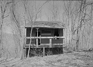
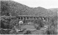
Jerome is an uninhabited community along the old Baltimore and Ohio Railroad main line in Morgan County in the U.S. state of West Virginia. It is located entirely within the Chesapeake and Ohio Canal National Historical Park on the Potomac River. Jerome is also the site of a stretch of the Western Maryland Railway right-of-way from milepost 126 to milepost 160 listed on the National Register of Historic Places. Located in the "Paw Paw Bends", Jerome was considered to be one of the most inaccessible places reached by the Western Maryland Rwy.
Green Ridge is a now uninhabited railroad community in Morgan County in the U.S. state of West Virginia on the old Baltimore and Ohio Railroad mainline where the Western Maryland Railroad crosses the Potomac River from the Stickpile Tunnel in Maryland. Green Ridge was originally known as Baird and was an operating station on the B&O. Today, it is located within the Chesapeake and Ohio Canal National Historical Park. A stretch of the Western Maryland's right-of-way from Green Ridge to Jerome is listed on the National Register of Historic Places.
Hansrote is an unincorporated community village in Morgan County in the U.S. state of West Virginia located along the old Baltimore and Ohio Railroad (B&O) mainline on the Potomac River. Hansrote is northeast of Magnolia and southwest of Doe Gully. Stuart Tunnel connected Hansrote and Magnolia by railroad, but today Hansrote is accessible by way of Hansrote Road from Magnolia Road. The former B&O mainline is now part of CSX Transportation and is a popular location with railfans.
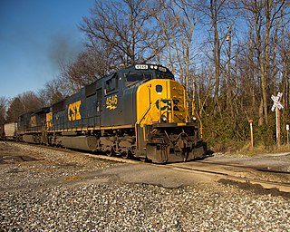
The Old Main Line Subdivision is a railroad line owned and operated by CSX Transportation in the U.S. state of Maryland. The line runs from Relay west to Point of Rocks, and was once the main line of the Baltimore and Ohio Railroad, one of the oldest rail lines in the United States. At its east end, it has junctions with the Capital Subdivision and the Baltimore Terminal Subdivision; its west end has a junction with the Metropolitan Subdivision.

The CSX Cumberland Subdivision is a railroad line owned and operated by CSX Transportation in the U.S. states of Maryland and West Virginia. The line runs from Brunswick, Maryland, west to Cumberland, Maryland, along the old Baltimore and Ohio Rail Road (B&O) main line. At its east end, the Cumberland Subdivision becomes the Metropolitan Subdivision; at its west end at Cumberland, Maryland it becomes the Cumberland Terminal Subdivision. It meets the Shenandoah Subdivision at Harpers Ferry, West Virginia, and the Lurgan Subdivision in Cherry Run, West Virginia.
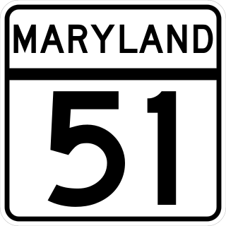
Maryland Route 51 is a state highway in the U.S. state of Maryland. Known for most of its length as Oldtown Road, the state highway runs 25.53 miles (41.09 km) from an interchange with Interstate 68 (I-68) in Cumberland south to the West Virginia state line at the Potomac River, where the highway continues east as West Virginia Route 9 toward Paw Paw. Around Cumberland, MD 51 is a major highway that provides a bypass of the South End neighborhood of that city and access to industrial areas along the North Branch Potomac River. South of North Branch, MD 51 is a rural highway connecting small communities along the river in southeastern Allegany County, including Oldtown. Documentation from the Maryland State Highway Administration depict the highway as following an east-west alignment, but all signage indicates a north-south road.
Canal Parkway, which carries the unsigned Maryland Route 61 designation, is a state highway and automobile parkway in the U.S. state of Maryland. The road begins at the West Virginia state line at the North Branch Potomac River opposite Wiley Ford, where the highway continues south as West Virginia Route 28. The parkway runs 1.94 miles (3.12 km) north to MD 51 within the city of Cumberland. Canal Parkway provides a connection between downtown Cumberland and the South Cumberland neighborhood and with Greater Cumberland Regional Airport, which is located in Mineral County, West Virginia.
The Patterson Creek Cutoff is an abandoned railroad line built by the Baltimore and Ohio Railroad (B&O) in northern West Virginia and Western Maryland, that served trains running on the B&O "West End" line in the Cumberland, Maryland area. The cutoff route ran from McKenzie, Maryland to Patterson Creek, West Virginia, providing a bypass of the B&O rail yard in Cumberland for coal trains moving between Keyser, West Virginia and Brunswick, Maryland.

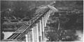
The B & O Railroad Potomac River Crossing is a 15-acre (6.1 ha) historic site where a set of railroad bridges, originally built by the Baltimore and Ohio Railroad, span the Potomac River between Sandy Hook, Maryland and Harpers Ferry, West Virginia. The site was added to the National Register of Historic Places on February 14, 1978 for its significance in commerce, engineering, industry, invention, and transportation.