
In structural geology, a syncline is a fold with younger layers closer to the center of the structure, whereas an anticline is the inverse of a syncline. A synclinorium is a large syncline with superimposed smaller folds. Synclines are typically a downward fold (synform), termed a synformal syncline, but synclines that point upwards can be found when strata have been overturned and folded.

North Mountain is a mountain ridge within the Ridge-and-valley Appalachians in the U.S. states of Virginia and West Virginia.

Whitetail Mountain Resort is a four-season resort located on Two Top Mountain, a mountain in the Bear Pond Mountains of Pennsylvania. The resort opened for skiing in 1991, and was acquired a few years later by Snow Time, Inc., the company which also manages Liberty Mountain Resort and Ski Roundtop. All three resorts were then acquired by Peak Resorts in 2018. Peak Resorts was then acquired by Vail Resorts in 2019.

Liberty Mountain Resort is a resort located in southern Pennsylvania. During the winter months the resort offers skiing, snowboarding, and snow tubing. The onsite hotel and lodge is open year-round and offers 114 rooms and multiple options for weddings and meetings. During the spring, summer, and fall the 18 hole Carroll Valley Golf Course at Liberty Mountain is open for a round of golf.
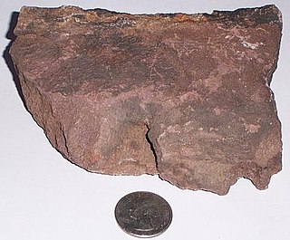
The Silurian Bloomsburg Formation is a mapped bedrock unit in Pennsylvania, New Jersey, New York and Maryland. It is named for the town of Bloomsburg, Pennsylvania in which it was first described. The Bloomsburg marked the first occurrence of red sedimentary rocks in the Appalachian Basin.

Hadley Mountain is a mountain located in the southern Adirondacks in the U.S. state of New York and is the second-highest peak in Saratoga County after neighboring Tenant Mountain. The Hadley Mountain Fire Observation Station was listed on the National Register of Historic Places on September 23, 2001 for its role as a Fire lookout tower with the New York State Forest Preserve. Hadley Mountain is the highest of the three peaks that form the West Mountain ridge.
Bearpen Mountain is a mountain located in the Catskill Mountains of New York. The mountain's highest peak is in Greene County, but its northwest subpeak at 42°16.42′N74°29.05′W is the highest point in Delaware County at 3,520 ft. Bearpen Mountain is flanked to the north by Roundtop, and to the southeast by Vly Mountain.

Wills Creek Formation is a mapped Silurian bedrock unit in Pennsylvania, Maryland, Virginia, and West Virginia.
Round Top is an extinct volcano in the Berkeley Hills, just east of Oakland, California.

The Roundtop Trail is an American hiking trail in Sevier County and Blount County sections of the Great Smoky Mountains National Park. The trail traverses the crest of Roundtop, a 3,077-foot (938 m) mountain that straddles the park's northern boundary. This trail, which passes through a thick forest of pine and oak and provides vistas of the valleys to the north and the mountains to the south, is one of the least-used trails in the park.

Wear Cove is a valley in southwestern Sevier County, Tennessee. It runs parallel to the Great Smoky Mountains National Park just to its south. Like other park border regions, the history and economy of the valley are intertwined with that of the Smokies. The primary community is Wears Valley.
Roundtop Hill is a mountain in Washington County, Maryland, southwest of the town of Hancock. The elevation at the summit is 1,358 feet (410 m).

The Roundtop Filling Station, in Sherwood, Arkansas, United States, is one of only two structures in Sherwood to be listed on the National Register of Historic Places, the other being Sylvan Hills Country Club Golf Course.
The Roundtop Mountain Resort is a resort located in Pennsylvania. During the winter months the resort offers skiing, snowboarding, and snowtubing. During the spring, summer, and fall, Roundtop offers zip lines, a ropes course, OGO Balls, and year-round paintball.
Roundtop Mountain is a mountain located in Greene County, New York south of Haines Falls, New York. Located to the east is High Peak and located to the northwest is Clum Hill. Roundtop Mountain drains north into Kaaterskill Creek and south into Schoharie Creek.
Roundtop is a mountain located in the Catskill Mountains of New York east-northeast of Roxbury. Hack Flats is located west-southwest, Negro Hill is located north, and Bearpen Mountain is located southeast of Roundtop.
Roundtop Mountain is a mountain located in the Catskill Mountains of New York north-northwest of Wittenberg. Beetree Hill is located east-northeast, Johns Mountain is located east-northeast, and Mount Tobias is located north-northwest of Roundtop Mountain.

Roundtop Mountain is a stratovolcano located on the Aleutian island of Unimak in the U.S. state of Alaska. Its last eruption was sometime between 9,100 and 10,000 years ago. This geographic feature was first called "Dome" in 1897 by Lieutenant Commander J. F. Moser, of the U.S. Navy. Its name was reported as "Round Top" by the U.S. Coast and Geodetic Survey in 1902. Isanotski Peaks, the nearest higher neighbor, is positioned 5.9 mi (9 km) to the west-southwest.


