
The National Road was the first major improved highway in the United States built by the federal government. Built between 1811 and 1837, the 620-mile (1,000 km) road connected the Potomac and Ohio Rivers and was a main transport path to the West for thousands of settlers. When improved in the 1830s, it became the second U.S. road surfaced with the macadam process pioneered by Scotsman John Loudon McAdam.

Rockville station is an intermodal train station located in downtown Rockville, Maryland, United States. It is served by the Washington Metro Red Line, MARC Brunswick Line commuter trains, and Amtrak Capitol Limited intercity trains.

The James River and Kanawha Canal was a partially built canal in Virginia intended to facilitate shipments of passengers and freight by water between the western counties of Virginia and the coast. Ultimately its towpath became the roadbed for a rail line following the same course.

The Western Maryland Railway was an American Class I railroad (1852–1983) which operated in Maryland, West Virginia, and Pennsylvania. It was primarily a coal hauling and freight railroad, with a small passenger train operation.

The National Register of Historic Places in the United States is a register including buildings, sites, structures, districts, and objects. The Register automatically includes all National Historic Landmarks as well as all historic areas administered by the U.S. National Park Service. Since its introduction in 1966, more than 90,000 separate listings have been added to the register.

Green Spring is a census-designated place (CDP) and railroad town in Hampshire County, West Virginia, United States. As of the 2010 census, its population was 218. Green Spring is located north of Springfield on Green Spring Road near the confluence of the North and South Branches of the Potomac River. Green Spring is also the location of the South Branch Valley Railroad's terminus with the old Baltimore & Ohio Railroad mainline. Green Spring is the site of a one-lane low-water toll bridge that connects Green Spring Road to Maryland Route 51 in Oldtown, Allegany County, Maryland. This bridge is one of only 17 privately owned toll bridges in the United States. The toll for the bridge is currently US$1.50.
Back Creek is a 59.5-mile-long (95.8 km) tributary of the Potomac River that flows north from Frederick County, Virginia, to Berkeley County in West Virginia's Eastern Panhandle. Back Creek originates along Frederick County's border with Hampshire County, West Virginia, at Farmer's Gap in the Great North Mountain. Its name reflects its location to the west of North Mountain. The perspective of colonists from the east in the 18th century led them to call it "Back Creek", because it lay to the back of North Mountain.

Oldtown is an unincorporated community and census-designated place (CDP) in Allegany County, Maryland, United States, along the North Branch Potomac River. As of the 2010 census, it had a population of 86.
Magnolia is an unincorporated community northeast of Paw Paw in Morgan County in the U.S. state of West Virginia on the Potomac River. Magnolia is located along the Baltimore and Ohio Railroad mainline and east of where the Western Maryland Railway crosses the Potomac, bypassing a series of bends in the river. As a depot and water station on the B&O, Magnolia has been known by a number of names including Magnolia Dale, Magnolia Vale, and sometimes as Water Station Number 12 on the railroad.
Jerome is an uninhabited community along the old Baltimore and Ohio Railroad main line in Morgan County in the U.S. state of West Virginia. It is located entirely within the Chesapeake and Ohio Canal National Historical Park on the Potomac River. Jerome is also the site of a stretch of the Western Maryland Railway right-of-way from milepost 126 to milepost 160 listed on the National Register of Historic Places. Located in the "Paw Paw Bends", Jerome was considered to be one of the most inaccessible places reached by the Western Maryland Rwy.
Hansrote is an unincorporated community village in Morgan County in the U.S. state of West Virginia located along the old Baltimore and Ohio Railroad (B&O) mainline on the Potomac River. Hansrote is northeast of Magnolia and southwest of Doe Gully. Stuart Tunnel connected Hansrote and Magnolia by railroad, but today Hansrote is accessible by way of Hansrote Road from Magnolia Road. The former B&O mainline is now part of CSX Transportation and is a popular location with railfans.
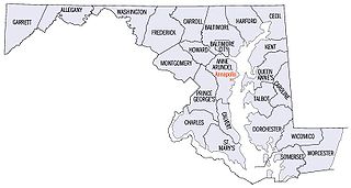
There are more than 1,500 properties and districts listed on the National Register of Historic Places in the U.S. State of Maryland. Each of the state's 23 counties and its one county-equivalent has at least 20 listings on the National Register.

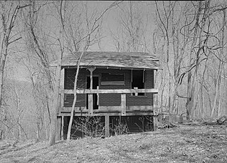
Western Maryland Railroad Right-of-Way, Milepost 126 to Milepost 160 is a historic section of the Western Maryland Railway (WM) in Allegany County, Maryland, and Morgan County, West Virginia. It is an abandoned 34-mile (55 km) section of the right-of-way between milepost 126 at the intersection of the Chesapeake and Ohio (C&O) Canal and Long Ridge Road, Woodmont, and milepost 160 just west of Maryland Route 51, North Branch. It closely parallels the Potomac River and the C&O Canal, which runs along the north bank of the river, and includes three tunnels. Seven miles of the roadbed are in West Virginia near Paw Paw.
North Branch is an unincorporated community in Allegany County, Maryland, United States. The Western Maryland Railroad Right-of-Way, Milepost 126 to Milepost 160 was listed on the National Register of Historic Places in 1981.
Woodmont is an unincorporated community in Washington County, Maryland, United States. Western Maryland Railroad Right-of-Way, Milepost 126 to Milepost 160 was listed on the National Register of Historic Places in 1980.
Western Maryland Railway Station, or W. M. Depot or W. M. Railroad Right-of-Way, may refer to:

Indigo Tunnel is an abandoned railroad tunnel in Allegany County, Maryland, located about 1 mile (1.6 km) east of Little Orleans. Built by the Western Maryland Railway (WM) in 1904 as part of its Cumberland Extension project from Hagerstown west to Cumberland along the Potomac River valley, which involved construction of four additional tunnels and 23 bridges, Indigo was the WM's longest tunnel. The new rail line opened in 1906. Trains ran through the tunnel until the rail line was abandoned by the newly formed Chessie System in 1975, in favor of the parallel Baltimore and Ohio railroad line on the opposite side of the Potomac River.

Kessler Tunnel is an abandoned railroad tunnel in Allegany County, Maryland, located about 8.5 miles (13.7 km) east-northeast of Oldtown. It was built by the Western Maryland Railway (WM) in 1906. It was constructed with concrete arch portals and the roof has wood planking. The tunnel was named for landowner John Kessler.

Stickpile Tunnel, also known as Greenridge Tunnel, is an abandoned railroad tunnel in Allegany County, Maryland, located about 2.5 miles (4.0 km) southwest of Little Orleans. It was built by the Western Maryland Railway (WM) in 1906. It was constructed with concrete arch portals and the roof has wood planking.


