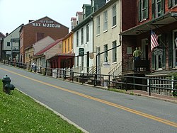
Harpers Ferry is a historic town in Jefferson County, West Virginia, in the lower Shenandoah Valley. The town's population was 269 at the 2020 United States census. Situated at the confluence of the Potomac and Shenandoah rivers, where Maryland, Virginia, and West Virginia meet, it is the easternmost town in West Virginia as well as its lowest point above sea level.

Jefferson County is located in the Shenandoah Valley in the Eastern Panhandle of West Virginia. It is the easternmost county of the U.S. state of West Virginia. As of the 2020 census, the population was 57,701. Its county seat is Charles Town. The county was founded in 1801, and today is part of the Washington metropolitan area.

Shepherdstown is a town in Jefferson County, West Virginia, United States, located in the lower Shenandoah Valley along the Potomac River. Home to Shepherd University, the town's population was 1,531 at the time of the 2020 census. The town was established in 1762 along with Romney; they are the oldest towns in West Virginia.

U.S. Route 340 is a spur route of US 40, and runs from Greenville, Virginia, to Frederick, Maryland. In Virginia, it runs north–south, parallel and east of US 11, from US 11 north of Greenville via Waynesboro, Grottoes, Elkton, Luray, Front Royal, and Berryville to the West Virginia state line. A short separate piece crosses northern Loudoun County on its way from West Virginia to Maryland.

Storer College was a historically Black college in Harpers Ferry, West Virginia, that operated from 1867 to 1955. A national icon for Black Americans, in the town where the 'end of American slavery began', as Frederick Douglass famously put it, it was a unique institution whose focus changed several times. There is no one category of college into which it fits neatly. Sometimes white students studied alongside Black students, which at the time was prohibited by law at state-regulated schools in West Virginia and the other Southern states.
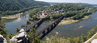
Harpers Ferry National Historical Park, originally Harpers Ferry National Monument, is located at the confluence of the Potomac and Shenandoah rivers in and around Harpers Ferry, West Virginia. The park includes the historic center of Harpers Ferry, notable as a key 19th-century industrial area and as the scene of John Brown's failed abolitionist uprising. It contains the most visited historic site in the state of West Virginia, John Brown's Fort.

John Brown's Fort was initially built in 1848 for use as a guard and fire engine house by the federal Harpers Ferry Armory, in Harpers Ferry, Virginia. An 1848 military report described the building as "An engine and guard-house 35 1/2 x 24 feet, one story brick, covered with slate, and having copper gutters and down spouts…"

Virginius Island is a formerly inhabited island of some 12 acres (4.9 ha), on the Shenandoah River in Harpers Ferry, West Virginia. The island was created by the Shenandoah Canal, constructed by the Patowmack Company between 1806 and 1807, which separates it from the town of Harpers Ferry. The canal was constructed to enable boats to bypass rapids on the river, and also channel water to drive machinery. In the nineteenth century Virginius Island contained Harpers Ferry's industry and working-class housing: a boarding house and row houses. Virginius Island is part of the Harpers Ferry National Historical Park.
Rippon is an unincorporated community in Jefferson County, West Virginia, United States, located south of Charles Town and designated as a village by the Jefferson County Commission. The village of Rippon developed in the mid-19th century at the crossroads of the Berryville and Charles Town Turnpike, Withers-LaRue Road, and Myerstown Road. The town was named after nearby Ripon Lodge, although an extra "p" was added to avoid confusion with a town in Wisconsin. According to the 2000 census, the town has a population of 223.

Jefferson Rock is a rock formation on the Appalachian Trail in Harpers Ferry, West Virginia. It consists of several large masses of Harpers shale, piled one upon the other, that overlook the Shenandoah River just prior to its confluence with the Potomac River. It was added to the National Register of Historic Places as a contributing property of the Harpers Ferry National Historical Park on October 15, 1966.

Harpers Ferry station is a railway station in Harpers Ferry, West Virginia. It is served by the Amtrak Floridian intercity service as well as MARC Brunswick Line commuter service. The station is listed on the National Register of Historic Places as part of the Harpers Ferry Historic District. It has two side platforms serving the two tracks of the CSX Cumberland Subdivision. The station is not accessible.

Martinsburg station is a railway station in Martinsburg, West Virginia, United States, served by MARC Brunswick Line commuter rail service and Amtrak Floridian intercity rail service. The station has one side platform serving a siding track of the CSX Cumberland Subdivision, with a footbridge crossing the siding and the two main tracks to provide access to the preserved Baltimore and Ohio Railroad Martinsburg Shops complex.
The Harpers Ferry Armory, more formally known as the United States Armory and Arsenal at Harpers Ferry, was the second federal armory created by the United States government; the first was the Springfield Armory. It was located in Harpers Ferry, Virginia, which since 1863 has been part of West Virginia. It was both an arsenal, manufacturing firearms, and an armory, a storehouse for firearms. Along with the Springfield Armory, it was instrumental in the development of machining techniques to make interchangeable parts of precisely the same dimensions.

St. Peter's Roman Catholic Church in Harpers Ferry, West Virginia occupies a prominent location on the heights above Harpers Ferry. The original church was built in 1833 in a pseudo-Gothic style which it kept through the Civil War, being the only church in Harpers Ferry to escape destruction during the war. The church was extensively altered in 1896 in the then-popular Neo-Gothic style to produce the church seen today. The church commands a sweeping vista across the gorge of the Shenandoah River above its confluence with the Potomac River. The street along the side of the church building is part of the Appalachian Trail. A short trail leads from the church to Jefferson Rock. St. Peter's Church is a mission church of St. James in Charles Town. Mass is offered at the historic church every Sunday at 9:30 a.m.

Shannondale Springs is a former American resort associated with mineral springs on the bank of the Shenandoah River upstream from Harpers Ferry, West Virginia. The water from the main spring was reputed to have mild laxative qualities, while other springs had a sulfurous odor. The resort began in 1820 with the construction of 10 to 12 wood cottages, and a two-story hotel was added the next year. The hotel and some of the cottages burned in 1858. After the Civil War several new brick cottages were built and a new hotel was built on the site of the old in 1890. This hotel burned in 1909 and was never rebuilt. The cottages and accessory structures lasted another thirty years before becoming uninhabitable.

The B & O Railroad Potomac River Crossing is a 15-acre (6.1 ha) historic site where a set of railroad bridges, originally built by the Baltimore and Ohio Railroad, span the Potomac River between Sandy Hook, Maryland and Harpers Ferry, West Virginia. The site was added to the National Register of Historic Places on February 14, 1978, for its significance in commerce, engineering, industry, invention, and transportation.

The Allstadt House and Ordinary was built about 1790 on land owned by the Lee family near Harpers Ferry, West Virginia, including Phillip Ludwell Lee, Richard Bland Lee and Henry Lee III. The house at the crossroads was sold to the Jacob Allstadt family of Berks County, Pennsylvania in 1811. Allstadt operated an ordinary in the house, and a tollgate on the Harpers Ferry-Charles Town Turnpike, while he resided farther down the road in a stone house. The house was enlarged by the Allstadts c. 1830. The house remained in the family until the death of John Thomas Allstadt in 1923, the last survivor of John Brown's Raid.

The Shepherdstown Historic District comprises the historic core of Shepherdstown, West Virginia. The town is the oldest in West Virginia, founded in 1762 as Mecklenburg. No structures are known to exist from the time before the town became known as Shepherdstown. The historic district is concentrated along German Street, the main street, with 386 contributing resources and 69 non-contributing elements. The chief representative period is the late 18th century, with many Federal style brick houses. German Street is also furnished with 19th-century "street furniture" such as metal fences, mounting blocks, wooden pumps and mature trees.

Knoxville is an unincorporated community in Frederick and Washington counties, Maryland, United States. The Robert Clagett Farm and Magnolia Plantation are listed on the National Register of Historic Places.
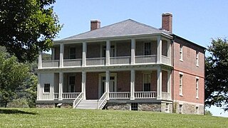
Lockwood House is a historic building in Harpers Ferry, West Virginia. One of the largest residences in Harpers Ferry, it is a massive stone and brick structure, located on the east side of Camp Hill at 360 Fillmore St., high above the town. It has a view of the town and the two rivers that meet there, the Shenandoah and the Potomac.