This is a list of the National Register of Historic Places listings in Pocahontas County, West Virginia.
Contents
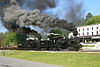
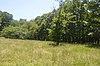
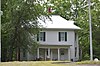
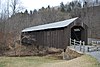
This is intended to be a complete list of the properties and districts on the National Register of Historic Places in Pocahontas County, West Virginia, United States. The locations of National Register properties and districts for which the latitude and longitude coordinates are included below, may be seen in an online map. [1]
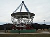
There are 23 properties and districts listed on the National Register in the county, 1 of which is a National Historic Landmark.
This National Park Service list is complete through NPS recent listings posted September 15, 2023. [2]
Barbour - Berkeley - Boone - Braxton - Brooke - Cabell - Calhoun - Clay - Doddridge - Fayette - Gilmer - Grant - Greenbrier - Hampshire - Hancock - Hardy - Harrison - Jackson - Jefferson - Kanawha - Lewis - Lincoln - Logan - Marion - Marshall - Mason - McDowell - Mercer - Mineral - Mingo - Monongalia - Monroe - Morgan - Nicholas - Ohio - Pendleton - Pleasants - Pocahontas - Preston - Putnam - Raleigh - Randolph - Ritchie - Roane - Summers - Taylor - Tucker - Tyler - Upshur - Wayne - Webster - Wetzel - Wirt - Wood - Wyoming |