Frost, West Virginia

Last updated
Frost, West Virginia
Unincorporated community
USA West Virginia location map.svg
Red pog.svg
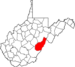
Location within the state of West Virginia
Usa edcp location map.svg
Red pog.svg
Frost, West Virginia (the US)
Coordinates: 38°16′14″N79°52′50″W / 38.27056°N 79.88056°W / 38.27056; -79.88056 Coordinates: 38°16′14″N79°52′50″W / 38.27056°N 79.88056°W / 38.27056; -79.88056
Country United States
State West Virginia
County Pocahontas
Elevation [1] 2,585 ft (788 m)
Time zone Eastern (EST) (UTC-5)
  Summer (DST) EDT (UTC-4)
ZIP code 24940
Area code(s) 304/681
GNIS feature ID 1554516

Frost is an unincorporated community in eastern Pocahontas County, West Virginia, United States. Frost is also home to Mountain Quest Institute.

Unincorporated area Region of land not governed by own local government

In law, an unincorporated area is a region of land that is not governed by a local municipal corporation; similarly an unincorporated community is a settlement that is not governed by its own local municipal corporation, but rather is administered as part of larger administrative divisions, such as a township, parish, borough, county, city, canton, state, province or country. Occasionally, municipalities dissolve or disincorporate, which may happen if they become fiscally insolvent, and services become the responsibility of a higher administration. Widespread unincorporated communities and areas are a distinguishing feature of the United States and Canada. In most other countries of the world, there are either no unincorporated areas at all, or these are very rare; typically remote, outlying, sparsely populated or uninhabited areas.

Pocahontas County, West Virginia County in the United States

Pocahontas County is a county located in the U.S. state of West Virginia. As of the 2010 census, the population was 8,719. Its county seat is Marlinton. The county was established in 1821. It is named after the daughter of the Powhatan Native American chief from Jamestown, Virginia. She married an English settler and their mixed-race children became ancestors of many of the First Families of Virginia.

West Virginia State of the United States of America

West Virginia is a state located in the Appalachian region in the Southern United States and is also considered to be a part of the Middle Atlantic States. It is bordered by Pennsylvania to the north, Maryland to the east and northeast, Virginia to the southeast, Kentucky to the southwest, and Ohio to the northwest. West Virginia is the 41st largest state by area, and is ranked 38th in population. The capital and largest city is Charleston.

The highly elevated townsite experiences frequent frost conditions, hence the name. [2]

Frost coating or deposit of ice that may form in humid air in cold conditions, usually overnight

Frost is a thin layer of ice on a solid surface, which forms from water vapor in an above freezing atmosphere coming in contact with a solid surface whose temperature is below freezing, and resulting in a phase change from water vapor to ice as the water vapor reaches the freezing point. In temperate climates, it most commonly appears on surfaces near the ground as fragile white crystals; in cold climates, it occurs in a greater variety of forms. The propagation of crystal formation occurs by the process of nucleation.

Climate

The climate in this area has mild differences between highs and lows, and there is adequate rainfall year-round. According to the Köppen Climate Classification system, Frost has a marine west coast climate, abbreviated "Cfb" on climate maps. [3]

Related Research Articles

Ghent, West Virginia Census-designated place in West Virginia, United States

Ghent is a census-designated place in Raleigh County in the U.S. state of West Virginia. As of the 2010 census, its population was 457.

Bergoo, West Virginia Census-designated place in West Virginia, United States

Bergoo is a census-designated place (CDP) in Webster County, West Virginia, United States. As of the 2010 census, its population was 94. Bergoo lies at the confluence of the Elk River and Leatherwood Creek. Bergoo was formerly known as Leatherwood, taking its name from the creek.

Mount Storm, West Virginia Unincorporated community in West Virginia, United States

Mount Storm is an unincorporated community in Grant County, West Virginia, United States. Mount Storm lies on the Northwestern Turnpike at its junction with West Virginia Route 42. The community is the site of the Union School Complex, which contains Union High School.

Sandyville, West Virginia Unincorporated community in West Virginia, United States

Sandyville is an unincorporated community in north central Jackson County, West Virginia, United States. It lies close to the left fork of Sandy Creek, nestled in the hills between Ravenswood and Ripley. It has a population of 1,721 and an average household income of $41,122.

Belva, West Virginia Census-designated place in West Virginia, United States

Belva is an unincorporated community and census-designated place in west Nicholas County and north Fayette County, West Virginia, United States; while the CDP only includes the Nicholas County portion, the Fayette County portion is considered part of the community. The town is situated at the bottomland surrounding the convergence of Bells Creek with Twentymile Creek and, subsequently, Twenty Mile Creek with the Gauley River. Belva is also the location of the convergence of two state highways: West Virginia Route 16 and West Virginia Route 39.

Neola, West Virginia Unincorporated community in West Virginia, United States

Neola is an unincorporated community in northeastern Greenbrier County, West Virginia, United States. It lies along West Virginia Route 92 north of the city of White Sulphur Springs. Its elevation is 2,037 feet (621 m).

Rock View, West Virginia Unincorporated community in West Virginia, United States

Rock View is an unincorporated community in Wyoming County, West Virginia, United States.

Arbovale, West Virginia Unincorporated community in West Virginia, United States

Arbovale is an unincorporated community in Pocahontas County, West Virginia, United States. Arbovale is 12 miles (19 km) south of Durbin. Arbovale had a post office, which closed on March 3, 2007.

Buckeye, West Virginia Unincorporated community in West Virginia, United States

Buckeye is an unincorporated community in Pocahontas County, West Virginia, United States. Buckeye is located along U.S. Route 219 3.5 miles (5.6 km) southwest of Marlinton. Buckeye has a post office with ZIP code 24924.

Dunmore, West Virginia Unincorporated community in West Virginia, United States

Dunmore is an unincorporated community in Pocahontas County, West Virginia, United States. Dunmore is located at the junction of West Virginia Route 28 and West Virginia Route 92 15 miles (24 km) northeast of Marlinton. Dunmore has a post office with ZIP code 24934.

Dellslow, West Virginia Unincorporated community in West Virginia, United States

Dellslow is an unincorporated community in Monongalia County, West Virginia, United States. Dellslow was established in 1798 and is located along West Virginia Route 7 near the southern border of Brookhaven. Dellslow has a post office with ZIP code 26531.

Valley Head, West Virginia Census-designated place (CDP) in West Virginia, United States

Valley Head is a census-designated place (CDP) in Randolph County, West Virginia, United States. Valley Head is located on U.S. Route 219 12 miles (19 km) south-southwest of Huttonsville. Valley Head has a post office with ZIP code 26294. As of the 2010 census, its population was 267.

Glady, West Virginia Unincorporated community in West Virginia, United States

Glady is an unincorporated community in Randolph County, West Virginia, United States. Glady is 11 miles (18 km) southeast of Elkins. Glady had a post office, which closed on May 14, 2011.

Pickens, West Virginia Census-designated place (CDP) in West Virginia, United States

Pickens is a census-designated place (CDP) in Randolph County, West Virginia, United States. Pickens is 13 miles (21 km) west-southwest of Huttonsville. It is the home of the Cunningham-Roberts Museum. Pickens has a post office with ZIP code 26230. As of the 2010 census, its population was 66.

Lorentz, West Virginia Unincorporated community in West Virginia, United States

Lorentz is an unincorporated community in Upshur County, West Virginia, United States. Lorentz is located on U.S. Route 33 and U.S. Route 119 4 miles (6.4 km) west-northwest of Buckhannon. Lorentz has a post office with ZIP code 26229.

Hico, West Virginia Census-designated place in West Virginia, United States

Hico is a census-designated place (CDP) in Fayette County, West Virginia, United States. Hico is located at the junction of U.S. Route 19 and U.S. Route 60 7 miles (11 km) northeast of Fayetteville. Hico has a post office with ZIP code 25854. As of the 2010 census, its population was 272.

Borderland, West Virginia Unincorporated community in West Virginia, United States

Borderland is an unincorporated community in Mingo County, West Virginia, United States. Borderland is located along the Tug Fork and U.S. Routes 52 and 119 3 miles (4.8 km) northwest of Williamson. Borderland had a post office, which opened on March 6, 1905, and closed on June 20, 2009.

Sprague, West Virginia Unincorporated community in West Virginia, United States

Sprague is an unincorporated community and coal town in Raleigh County, West Virginia, United States. Sprague is located on West Virginia Route 16 1 mile (1.6 km) north of downtown Beckley. Sprague has a post office with ZIP code 25926.

Redstar, West Virginia Unincorporated community in West Virginia, United States

Redstar is an unincorporated community in Fayette County, West Virginia, United States. Redstar is 2.5 miles (4.0 km) south of Oak Hill. Redstar had a post office with ZIP code 25914, which closed on January 20, 2007.

Procious, West Virginia Unincorporated community in West Virginia, United States

Procious is an unincorporated community in Clay County, West Virginia, United States. Procious is located on the Elk River and West Virginia Route 4, 7 miles (11 km) west-northwest of Clay. Procious has a post office with ZIP code 25164.

References