
Monongalia County, known locally as Mon County, is a county in the U.S. state of West Virginia. As of the 2010 census, the population was 96,189, making it West Virginia's third-most populous county. Its county seat is at Morgantown. The county was founded in 1776.

Radford is an independent city in the U.S. state of Virginia. As of 2016, the population was estimated to be 17,483 by the United States Census Bureau. For statistical purposes, the Bureau of Economic Analysis combines the city of Radford with neighboring Montgomery County.

Bristol is an independent city in the Commonwealth of Virginia. As of the 2010 census, the population was 17,835. It is the twin city of Bristol, Tennessee, just across the state line, which runs down the middle of its main street, State Street. The Bureau of Economic Analysis combines the city of Bristol, Virginia, with neighboring Washington County, Virginia, for statistical purposes. Bristol is a principal city of the Kingsport–Bristol–Bristol, TN-VA Metropolitan Statistical Area, which is a component of the Johnson City–Kingsport–Bristol, TN-VA Combined Statistical Area – commonly known as the "Tri-Cities" region.
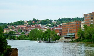
Morgantown is a city in and the county seat of Monongalia County, West Virginia, United States, situated along the banks of the Monongahela River. It is known as the home of West Virginia University and the Morgantown Personal Rapid Transit (PRT) system. With a permanent population of 31,073 per the 2015 U.S. Census estimates, Morgantown is the largest city in North-Central West Virginia. The Morgantown metropolitan area has a population of 138,176.

Sunset Boulevard is a boulevard in the central and western part of Los Angeles County, California that stretches from the Pacific Coast Highway in Pacific Palisades east to Figueroa Street in Downtown Los Angeles. It is a major thoroughfare in the cities of Beverly Hills and West Hollywood, as well as several districts in Los Angeles.
The Sunset Strip is the 1 1⁄2-mile (2.4 km) stretch of Sunset Boulevard that passes through the city of West Hollywood, California, United States. It extends from West Hollywood's eastern border with the city of Los Angeles (Hollywood) at Crescent Heights Boulevard to its western border with Beverly Hills at Sierra Drive. The Sunset Strip is known for its boutiques, restaurants, rock clubs, and nightclubs, as well as its array of huge, colorful billboards.
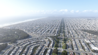
The Sunset District is a neighborhood located in the west-central area of San Francisco, California, United States. It is the largest neighborhood in the West Of Twin Peaks Neighborhoods in San Francisco.

Lookout Mountain is a mountain ridge located at the northwest corner of the U.S. state of Georgia, the northeast corner of Alabama, and along the Tennessee state line in Chattanooga. Lookout Mountain was the scene of the "Last Battle of the Cherokees" during the Nickajack Expedition, which took place in the 18th century, as well as the November 24, 1863 Battle of Lookout Mountain during the American Civil War.
Sunset Terrace and Montclair Place are two Inner Loop neighborhoods of Houston, Texas, United States. The two subdivisions are served by the Sunset Terrace/Montclair Civic Association.

Maplewood is an unincorporated community in Fayette County, West Virginia, United States. Maplewood is located on West Virginia Route 41 6.5 miles (10.5 km) northwest of Meadow Bridge.
Danese is an unincorporated community in Fayette County, West Virginia, United States. Danese is located on West Virginia Route 41 5.5 miles (8.9 km) northwest of Meadow Bridge. Danese has a post office with ZIP code 25831.

Layland is an unincorporated community in Fayette County, West Virginia, United States. Layland is located on West Virginia Route 41 6.5 miles (10.5 km) west-northwest of Meadow Bridge. Layland has a post office with ZIP code 25864.
Dixie is a census-designated place (CDP) in Fayette and Nicholas counties, West Virginia, United States. Dixie is located on West Virginia Route 16 5.5 miles (8.9 km) north of Gauley Bridge. Dixie has a post office with ZIP code 25059. As of the 2010 census, its population was 291, with 202 residents in Nicholas County and 89 in Fayette County.

Omar is a census-designated place (CDP) in Logan County, West Virginia, United States. Omar is located along West Virginia Route 44 and Island Creek, 6.5 miles (10.5 km) south of Logan. Omar has a post office with ZIP code 25638. As of the 2010 census, its population was 522.
"Sunset Hill", also known as the Alderson Home, is a historic home located at Alderson, Monroe County, West Virginia. The main farmhouse was built in 1880, and is a two-story I house with side gables and a two-story ell. The front facade features a gable portico supported by four Doric order columns. Also on the property are a contributing cottage, privy built by the Works Progress Administration, barn, cistern, and entrance gates.
Sunset Court is an unincorporated community in Logan County, West Virginia.
Sunset Heights is an unincorporated community in Wood County, West Virginia.
Sunset Beach is an unincorporated community in Monongalia County, West Virginia.

Sunset Trail Ranch is a populated place situated in the far west of Maricopa County, Arizona. It has an estimated elevation of 1,493 feet (455 m) above sea level.


