
The Battle of Blue Licks, fought on August 19, 1782, was one of the last battles of the American Revolutionary War. The battle occurred ten months after Lord Cornwallis's surrender at Yorktown, which had effectively ended the war in the east. On a hill next to the Licking River in what is now Robertson County, Kentucky, a force of about 50 Loyalists along with 300 American Indians ambushed and routed 182 Kentucky militiamen. It was the last victory for the Loyalists and Indians during the frontier war. British, Loyalist and Native Indian forces would engage in fighting with American forces once more the following month in Wheeling, West Virginia, during the Siege of Fort Henry.

A mineral lick is a place where animals can go to lick essential mineral nutrients from a deposit of salts and other minerals. Mineral licks can be naturally occurring or artificial. Natural licks are common, and they provide essential elements such as phosphorus and the biometals required in the springtime for bone, muscle and other growth in deer and other wildlife, such as moose, elephants, tapirs, cattle, woodchucks, domestic sheep, fox squirrels, mountain goats and porcupines. Such licks are especially important in ecosystems with poor general availability of nutrients. Harsh weather exposes salty mineral deposits that draw animals from miles away for a taste of needed nutrients. It is thought that certain fauna can detect calcium in salt licks.

Kirby is an unincorporated community in Hampshire County in the U.S. state of West Virginia situated along Grassy Lick Run, a tributary of North River. Kirby is located south of Romney at the crossroads of Grassy Lick Road and Rock Oak Road.

Opequon Creek is a 64.4-mile-long (103.6 km) tributary stream of the Potomac River. It flows into the Potomac northeast of Martinsburg in Berkeley County, West Virginia, and its source lies northwest of the community of Opequon at the foot of Great North Mountain in Frederick County, Virginia. The Opequon forms part of the boundary between Frederick and Clarke counties in Virginia and also partially forms the boundary between Berkeley and Jefferson counties in West Virginia's Eastern Panhandle.

Nathaniel Mountain Wildlife Management Area is located on 10,675 acres (43.20 km2) south of Romney in Hampshire County, West Virginia. The wildlife management area's principle access road is off Grassy Lick Road. Nathaniel Mountain is owned by the West Virginia Division of Natural Resources (WVDNR), and is one of West Virginia's largest wildlife management areas. The WMA was expanded in November 2003 after the WVDNR purchased 1,800 acres (7.3 km2) from the MeadWestvaco Corporation.

Grassy Lick Run is a 7.1-mile-long (11.4 km) tributary stream of the North River, itself a tributary of the Cacapon River, making it a part of the Potomac River and Chesapeake Bay watersheds. Grassy Lick Run flows south through the community of Kirby.
Kettle Creek is a 7.3-mile-long (11.7 km) tributary stream of the South Fork South Branch Potomac River in Hardy and Pendleton counties in West Virginia's Eastern Panhandle. Kettle Creek rises on Mitchell Knob and flows north along the eastern flanks of Sweedlin Hill through Sweedlin Valley in the George Washington National Forest.

Charles Phillips Dorr was a lawyer and Republican politician from West Virginia who served as a United States Representative in the 55th United States Congress. Dorr was born in Miltonsburg, Ohio in Monroe County.
Clover Lick is an unincorporated community in Pocahontas County, West Virginia, United States. Clover Lick is located along the Greenbrier River, 10 miles (16 km) northeast of Marlinton. The community is home to the Clover Lick Train Depot, which sits along the Greenbrier River Trail at Milepost 71.2. Clover Lick was founded in the early 1900s as a place to board trains traveling along the Greenbrier River.
Lick Creek is an unincorporated community in Summers County, West Virginia, United States. Lick Creek is located near the west bank of the New River, 21 miles (34 km) south of Hinton.
Lorton Lick is an unincorporated community in Mercer County, West Virginia, United States. Lorton Lick is located on West Virginia Route 71, 1.5 miles (2.4 km) south-southeast of Montcalm.

The North River is a tributary of the Cacapon River, belonging to the Potomac River and Chesapeake Bay watersheds. The river is located in Hampshire and Hardy counties in the U.S. state of West Virginia's Eastern Panhandle. The mouth of the North River into the Cacapon is located at Forks of Cacapon. From its headwaters to its mouth, the North River spans 52.4 miles (84.3 km) in length.
The Lost River is a 31.1-mile-long (50.1 km) river in the Appalachian Mountains of Hardy County in West Virginia's Eastern Panhandle region. The Lost River is geologically the same river as the Cacapon River: It flows into an underground channel northeast of McCauley along West Virginia Route 259 at "the Sinks" and reappears near Wardensville as the Cacapon. The source of the Lost River lies south of Mathias near the West Virginia/Virginia border. Along with the Cacapon and North rivers, the Lost River serves as one of the three main segments of the Cacapon River and its watershed.
Bone Lick was an unincorporated community located in Raleigh County, West Virginia, United States. Bone Lick had a Post Office in 1935.
Buffalo Lick was an unincorporated community located in Roane County, West Virginia, United States.
Katy Lick is an unincorporated community in Harrison County, West Virginia, United States.
Lick Fork is an unincorporated community and coal town in Fayette County, West Virginia, United States.
Rensford is an unincorporated community in Kanawha County, West Virginia, United States. Its post office is closed. It was also known as Point Lick.
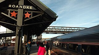
Roanoke is a train station in Roanoke, Virginia, the current terminus of Amtrak's Northeast Regional line. Built in 2017, it follows several other Roanoke passenger stations that operated from the 1850s to 1979. The station consists of a single high-level platform with a heated shelter. It is unstaffed, with no baggage service. All tickets must be purchased in advance; there is no Quik-Trak kiosk at the station.


