Droop, West Virginia

Last updated
Droop
USA West Virginia location map.svg
Red pog.svg
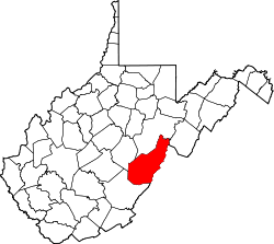
Droop
Location within the state of West Virginia
Usa edcp location map.svg
Red pog.svg
Droop
Droop (the United States)
Coordinates: 38°5′6″N80°17′5″W / 38.08500°N 80.28472°W / 38.08500; -80.28472 Coordinates: 38°5′6″N80°17′5″W / 38.08500°N 80.28472°W / 38.08500; -80.28472
Country United States
State West Virginia
County Pocahontas
Time zone UTC-5 (Eastern (EST))
  Summer (DST) UTC-4 (EDT)
ZIP codes
24933

Droop is an unincorporated community in Pocahontas County, West Virginia, United States, in the Greenbrier River Valley.

Contents

The community takes its name from nearby Droop Mountain. [1] The area lends its name to Droop Mountain Battlefield State Park, site of West Virginia's last significant Civil War battle. [2] The Civilian Conservation Corps (CCC) constructed the park's trails and buildings in the 1930s, as part of Franklin D. Roosevelt's New Deal legislation. Today, a small museum on the park grounds houses Civil War artifacts and discusses the park's CCC history. [3] Bi-annually, the West Virginia Reenactors Association reenacts the Droop Mountain battle. [4]

Places of interest

Related Research Articles

Civilian Conservation Corps US voluntary public work relief program from 1933-42

The Civilian Conservation Corps (CCC) was a voluntary public work relief program that operated from 1933 to 1942 in the United States for unemployed, unmarried men ages 18–25 and eventually expanded to ages 17–28. Robert Fechner was the first director of this agency, succeeded by James McEntee following Fechner's death. The CCC was a major part of President Franklin D. Roosevelt's New Deal that provided manual labor jobs related to the conservation and development of natural resources in rural lands owned by federal, state, and local governments. The CCC was designed to provide jobs for young men and to relieve families who had difficulty finding jobs during the Great Depression in the United States. Maximum enrollment at any one time was 300,000. Through the course of its nine years in operation, three million young men participated in the CCC, which provided them with shelter, clothing, and food, together with a wage of $30 per month.

Red Rocks Park United States historic place

Red Rocks Park is a mountain park in Jefferson County, Colorado, owned and maintained by the city of Denver as part of the Denver Mountain Parks system. The park is known for its very large red sandstone outcrops. Many of these rock formations within the park have names, from the mushroom-shaped Seat of Pluto to the inclined Cave of the Seven Ladders. The most visited rocks, around Red Rocks Amphitheatre, are Creation Rock to the north, Ship Rock to the south, and Stage Rock to the east.

Fort Phil Kearny United States historic place

Fort Phil Kearny was an outpost of the United States Army that existed in the late 1860s in present-day northeastern Wyoming along the Bozeman Trail. Construction began in 1866 on Friday, July 13, by Companies A, C, E, and H of the 2nd Battalion, 18th Infantry, under the direction of the regimental commander and Mountain District commander Colonel Henry B. Carrington.

Seminary Ridge

Seminary Ridge is a dendritic ridge which was an area of Battle of Gettysburg engagements in July 1863 during the American Civil War (1861–1865), and of military installations during World War II (1941–1945).

Kennesaw Mountain

Kennesaw Mountain is a mountain ridge between Marietta and Kennesaw, Georgia in the United States with a summit elevation of 1,808 feet (551 m). It is the highest point in the core metro Atlanta area, and fifth after further-north exurban counties are considered. The local terrain averages roughly 1,000 feet AMSL.

Droop Mountain Battlefield State Park

Droop Mountain Battlefield State Park is a state park located on Droop Mountain in Pocahontas County, West Virginia. The park was the site of the Battle of Droop Mountain, the last major battle of the American Civil War in the state taking place on November 6, 1863. John D. Sutton, a West Virginia private in the Union Army at the battle, became the leader in the movement to create the park when he served in the West Virginia House of Delegates. Dedicated on July 4, 1928, Droop Mountain Battlefield became the first state park in West Virginia.

Hawks Nest State Park

Hawks Nest State Park is located on 370 acres (150 ha) in Fayette County near Ansted, West Virginia. The park's clifftop overlook along U.S. Route 60 provides a scenic vista of the New River, some 750 feet below. The hydro-electric project tunnel that passes underneath nearby Gauley Mountain was the scene of the Depression-era Hawks Nest Tunnel disaster.

Watoga State Park State park in Pocahontas County, West Virginia, USA

Watoga State Park is a state park located near Seebert in Pocahontas County, West Virginia. The largest of West Virginia's state parks, it covers slightly over 10,100 acres (41 km2). Nearby parks include the Greenbrier River Trail, which is adjacent to the park, Beartown State Park, and Droop Mountain Battlefield State Park. Also immediately adjacent to the park is the 9,482-acre Calvin Price State Forest.

Coopers Rock State Forest

Coopers Rock State Forest is a 12,747-acre (52 km2) state forest in Monongalia and Preston counties in the U.S. state of West Virginia. Its southern edge abuts Cheat Lake and the canyon section of Cheat River, a popular whitewater rafting river in the eastern United States.

Fort Valley (Virginia)

Fort Valley is a mountain valley located primarily in Shenandoah County, Virginia. It is often called "valley within a valley" as it lies between the two arms of the northern part of the Blue Ridge mountain range in the Shenandoah Valley in the Ridge-and-Valley Appalachians geological zone.

Kooser State Park

Kooser State Park is a 250-acre (101 ha) Pennsylvania state park in Jefferson Township, Somerset County, Pennsylvania, in the United States. The park, which borders Forbes State Forest, was built in the 1930s by the Civilian Conservation Corps, who also built the 4-acre (1.6 ha) Kooser Lake by damming Kooser Run. Kooser State Park is on Pennsylvania Route 31 a one-hour drive from Pittsburgh. The park is surrounded by Forbes State Forest.

Douthat State Park Park in the Appalachians, United States

Douthat State Park is a state park located in the Allegheny Mountains in Virginia. It is in Bath County and Alleghany County. The park is 4,545 acres (18 km2) total with a 50-acre (20 ha) lake.

Table Rock State Park (South Carolina) United States historic place

Table Rock State Park is a 3,083-acre (12.48 km2) park at the edge of the Blue Ridge Mountains in northern Pickens County, South Carolina. The park includes Pinnacle Mountain, the tallest mountain totally within the state.

DeSoto State Park

DeSoto State Park is a public recreation area located on Lookout Mountain 8 miles (13 km) northeast of Fort Payne, Alabama. The state park covers 3,502 acres (1,417 ha) of forest, rivers, waterfalls, and mountain terrain. It borders the Little River, which flows into the nearby Little River Canyon National Preserve. The 104-foot-tall (32 m) DeSoto Falls, the state's highest waterfall, is found in a separate part of the park 6 miles (9.7 km) north of the main park.

Droop Mountain is a small mountain in the Allegheny Mountains on the border of Greenbrier and Pocahontas counties in southeastern West Virginia. It was the scene of one of West Virginia's most important battles during the American Civil War—the Battle of Droop Mountain.

Pocahontas State Park State park in Virginia, United States

Pocahontas State Park is a state park located in Chesterfield, Virginia, United States, not far from the state capitol of Richmond. The park was laid out by the Civilian Conservation Corps along the Swift Creek, and at 7,950 acres (32.2 km2) was, at its creation, Virginia's largest state park.

Devils Den State Park

Devil's Den State Park is a 2,500-acre (1,000 ha) Arkansas state park in Washington County, near West Fork, Arkansas in the United States. The park was built by the Civilian Conservation Corps, beginning in 1933. Devil's Den State Park is in the Lee Creek Valley in the Boston Mountains, which are the southwestern part of The Ozarks. The park, with an 8 acres (3.2 ha) CCC-built lake, is open for year-round recreation, with trails for hiking, mountain biking and horseback riding. Devil's Den State Park also has several picnic areas, a swimming pool and cabins, with camping sites ranging from modern to primitive. Fossils of coral and crinoids can be found along the banks and within Lee Creek at Devil's Den State Park.

Quiet Dell, West Virginia Unincorporated community in West Virginia, United States

Quiet Dell is an unincorporated community in Harrison County, West Virginia, United States. Quiet Dell is located at the junction of Interstate 79 and West Virginia Route 20, 5 miles (8.0 km) southeast of Clarksburg.

Hopkins Mountain Historic District United States historic place

Hopkins Mountain Historic District is a national historic district located in the Monongahela National Forest near Alvon, Greenbrier County, West Virginia. The district encompasses two contributing buildings, one contributing site, and two contributing structures. It includes the Mountain Tower Road, fire tower and the fireman's residence. They were all constructed by the members of Camp Alvon of the Civilian Conservation Corps (CCC) in 1935. The house is a Bungalow style, gable roofed dwelling measuring 14 feet by 20 feet. Located nearby is a contemporary privy with board-and-batten siding and a gable roof, also built by the CCC. The property also includes the Civil War Trail. It was used by the Virginia 26th Battalion under the command of Lt. Colonel George M. Edgar for its retreat from the Battle of Droop Mountain on November 6 and 7, 1863. Also on the property is a logging tramway in use from about 1908 to the 1920s.

The Civil War Trust's Civil War Discovery Trail is a heritage tourism program that links more than 600 U.S. Civil War sites in more than 30 states. The program is one of the White House Millennium Council's sixteen flagship National Millennium Trails. Sites on the trail include battlefields, museums, historic sites, forts and cemeteries.

References

  1. Kenny, Hamill (1945). West Virginia Place Names: Their Origin and Meaning, Including the Nomenclature of the Streams and Mountains. Piedmont, WV: The Place Name Press. p. 214.
  2. Moyer, Armond; Moyer, Winifred (1958). The origins of unusual place-names. Keystone Pub. Associates. p. 38.
  3. http://www.droopmountainbattlefield.com
  4. http://www.wvra.org