National Register of Historic Places listings in Hardy County, West Virginia

Last updated
Location of Hardy County in West Virginia Map of West Virginia highlighting Hardy County.svg
Location of Hardy County in West Virginia

This is a list of the National Register of Historic Places listings in Hardy County, West Virginia.

Contents

This is intended to be a complete list of the properties and districts on the National Register of Historic Places in Hardy County, West Virginia, United States. The locations of National Register properties and districts for which the latitude and longitude coordinates are included below, may be seen in a Google map. [1]

There are 25 properties and districts listed on the National Register in the county.

This National Park Service list is complete through NPS recent listings posted January 15, 2021. [2]
Map all coordinates using: OpenStreetMap  
Download coordinates as: KML  ·  GPX
Contents: Counties in West Virginia

Listings county-wide

[3] Name on the Register [4] ImageDate listed [5] Location City or townDescription
1 Judge J. W. F. Allen House
Judge J. W. F. Allen House Judge J. W. F. Allen House 2020.jpg
Judge J. W. F. Allen House
February 10, 1983
(#83003237)
South Fork Rd.
39°03′24″N78°57′42″W / 39.056667°N 78.961667°W / 39.056667; -78.961667 (Judge J. W. F. Allen House)
Moorefield
2 Buena Vista Farms
Buena Vista Farms Buena Vista Farms 2020.jpg
Buena Vista Farms
July 10, 1985
(#85001594)
U.S. Route 220
39°07′47″N78°57′02″W / 39.129722°N 78.950556°W / 39.129722; -78.950556 (Buena Vista Farms)
Old Fields
3 Fort Pleasant
Fort Pleasant Fort Pleasant 2020.jpg
Fort Pleasant
July 16, 1973
(#73001903)
North of Moorefield
39°08′01″N78°56′55″W / 39.133611°N 78.948611°W / 39.133611; -78.948611 (Fort Pleasant)
Moorefield
4 Henry Funkhouser Farm and Log House November 29, 2001
(#01001326)
Funkhouser Rd., County Roads 259/9
39°01′21″N78°46′14″W / 39.0225°N 78.770556°W / 39.0225; -78.770556 (Henry Funkhouser Farm and Log House)
Baker
5 Hickory Hill
Hickory Hill Hickory Hill Petersburg WV 2014 07 29 12.JPG
Hickory Hill
July 10, 1985
(#85001596)
U.S. Route 220
38°59′57″N79°04′14″W / 38.999167°N 79.070556°W / 38.999167; -79.070556 (Hickory Hill)
Petersburg
6 P.W. Inskeep House
P.W. Inskeep House P. W. Inskeep House 2020b.jpg
P.W. Inskeep House
July 10, 1985
(#85001597)
WV 55
39°04′13″N78°57′25″W / 39.070278°N 78.956944°W / 39.070278; -78.956944 (P.W. Inskeep House)
Moorefield
7 Francis Kotz Farm December 22, 2008
(#08001237)
27625 WV 55
39°04′39″N78°36′16″W / 39.0775°N 78.604444°W / 39.0775; -78.604444 (Francis Kotz Farm)
Wardensville
8 Lighthorse Harry Lee Cabin
Lighthorse Harry Lee Cabin Lighthorse Harry Lee Cabin Mathias WV 2014 06 21 04.jpg
Lighthorse Harry Lee Cabin
July 30, 1974
(#74002001)
West of Mathias in Lost River State Park
38°53′41″N78°55′25″W / 38.894722°N 78.923611°W / 38.894722; -78.923611 (Lighthorse Harry Lee Cabin)
Mathias
9 Lost River General Store
Lost River General Store Lost River General Store.jpg
Lost River General Store
November 30, 2005
(#05001349)
6993 WV 259
38°57′11″N78°48′16″W / 38.953056°N 78.804306°W / 38.953056; -78.804306 (Lost River General Store)
Lost River
10 Thomas Maslin House
Thomas Maslin House Thomas Maslin House 2020a.jpg
Thomas Maslin House
August 29, 1979
(#79002578)
131 Main St.
39°03′36″N78°58′09″W / 39.06°N 78.969167°W / 39.06; -78.969167 (Thomas Maslin House)
Moorefield
11 John Mathias House
John Mathias House John Mathias House Mathias WV 2014 06 21 13.jpg
John Mathias House
November 24, 1978
(#78002796)
WV 259
38°52′39″N78°52′03″W / 38.8775°N 78.8675°W / 38.8775; -78.8675 (John Mathias House)
Mathias
12 The Meadows January 14, 1986
(#86000777)
U.S. Route 220
39°05′09″N78°57′20″W / 39.085833°N 78.955556°W / 39.085833; -78.955556 (The Meadows)
Moorefield
13 Mill Island July 2, 1973
(#73001904)
South of Moorefield
39°02′22″N78°57′38″W / 39.039444°N 78.960556°W / 39.039444; -78.960556 (Mill Island)
Moorefield
14 Moorefield Historic District
Moorefield Historic District McCoy's Grand Theatre 2020b.jpg
Moorefield Historic District
January 15, 1986
(#86000774)
Portions of Main, Elm, Washington, and Winchester Sts.
39°03′35″N78°58′12″W / 39.059722°N 78.97°W / 39.059722; -78.97 (Moorefield Historic District)
Moorefield
15 New Deal Resources in Lost River State Park Historic District
New Deal Resources in Lost River State Park Historic District Lost River State Park.jpg
New Deal Resources in Lost River State Park Historic District
February 4, 2011
(#10001226)
321 Park Dr.
38°53′33″N78°55′38″W / 38.8925°N 78.927222°W / 38.8925; -78.927222 (New Deal Resources in Lost River State Park Historic District)
Mathias New Deal Resources in West Virginia State Parks and Forests MPS
16 Oakland Hall July 10, 1985
(#85001598)
U.S. Route 220
39°00′26″N79°00′12″W / 39.007222°N 79.003333°W / 39.007222; -79.003333 (Oakland Hall)
Moorefield
17 Old Hardy County Courthouse
Old Hardy County Courthouse McCoy's Grand Theatre 2020b.jpg
Old Hardy County Courthouse
October 9, 1974
(#74002002)
Winchester Ave. and Elm St.
39°03′43″N78°58′05″W / 39.061944°N 78.968056°W / 39.061944; -78.968056 (Old Hardy County Courthouse)
Moorefield
18 Old Stone Tavern
Old Stone Tavern Old Stone Tavern 2020b.jpg
Old Stone Tavern
December 10, 1979
(#79002579)
117 Main St.
39°03′40″N78°58′11″W / 39.061111°N 78.969722°W / 39.061111; -78.969722 (Old Stone Tavern)
Moorefield
19 Stump Family Farm December 15, 1998
(#98001471)
WV 7, southern fork of the Potomac River
38°54′31″N79°01′10″W / 38.908611°N 79.019444°W / 38.908611; -79.019444 (Stump Family Farm)
Moorefield
20 Nicholas Switzer House December 24, 2008
(#08001238)
County Route 5 and Waites Run
39°04′48″N78°34′54″W / 39.08°N 78.581667°W / 39.08; -78.581667 (Nicholas Switzer House)
Wardensville
21 Garrett VanMeter House March 27, 2001
(#01000264)
Off Reynolds Gap Rd.
39°08′14″N78°56′13″W / 39.137222°N 78.936944°W / 39.137222; -78.936944 (Garrett VanMeter House)
Old Fields
22 Westfall Place July 10, 1985
(#85001599)
U.S. Route 220
39°01′01″N79°00′03″W / 39.016944°N 79.000833°W / 39.016944; -79.000833 (Westfall Place)
Moorefield
23 Willow Wall
Willow Wall WILLOW WALL.jpg
Willow Wall
July 2, 1973
(#73001906)
South of Old Fields
39°07′40″N78°57′56″W / 39.127778°N 78.965556°W / 39.127778; -78.965556 (Willow Wall)
Old Fields
24 The Willows July 2, 1973
(#73001905)
South of Moorefield
39°02′00″N78°57′43″W / 39.033333°N 78.961944°W / 39.033333; -78.961944 (The Willows)
Moorefield
25 Wilson-Kuykendall Farm
Wilson-Kuykendall Farm WILSON-KUYKENDALL FARM.jpg
Wilson-Kuykendall Farm
July 10, 1985
(#85001600)
U.S. Route 220
39°02′20″N78°59′10″W / 39.038889°N 78.986111°W / 39.038889; -78.986111 (Wilson-Kuykendall Farm)
Moorefield

See also

Related Research Articles

National Register of Historic Places listings in Berkeley County, West Virginia

This is a list of the National Register of Historic Places listings in Berkeley County, West Virginia.

National Register of Historic Places listings in Jefferson County, West Virginia

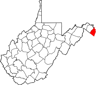
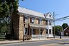
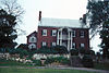
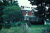
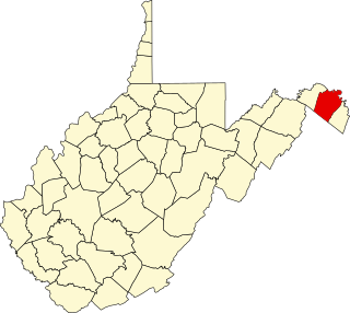
This is a list of the National Register of Historic Places listings in Jefferson County, West Virginia.

National Register of Historic Places listings in Preston County, West Virginia

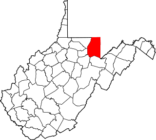
This is a list of the National Register of Historic Places listings in Preston County, West Virginia. This is intended to be a complete list of the properties and districts on the National Register of Historic Places in Preston County, West Virginia. The locations of National Register properties and districts for which the latitude and longitude coordinates are included below, may be seen in a Google map.

National Register of Historic Places listings in Brooke County, West Virginia

This is a list of the National Register of Historic Places listings in Brooke County, West Virginia.

National Register of Historic Places listings in Monroe County, West Virginia

This is a list of the National Register of Historic Places listings in Monroe County, West Virginia.

National Register of Historic Places listings in Nicholas County, West Virginia

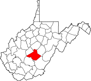
This is a list of the National Register of Historic Places listings in Nicholas County, West Virginia.

National Register of Historic Places listings in Morgan County, West Virginia

This is a list of the National Register of Historic Places listings in Morgan County, West Virginia.

National Register of Historic Places listings in Mason County, West Virginia

This is a list of the National Register of Historic Places listings in Mason County, West Virginia.

National Register of Historic Places listings in Pendleton County, West Virginia

This is a list of the National Register of Historic Places listings in Pendleton County, West Virginia.

National Register of Historic Places listings in Mineral County, West Virginia

This is a list of the National Register of Historic Places listings in Mineral County, West Virginia.

National Register of Historic Places listings in Mingo County, West Virginia

This is a list of the National Register of Historic Places listings in Mingo County, West Virginia.

National Register of Historic Places listings in Wetzel County, West Virginia

This is a list of the National Register of Historic Places listings in Wetzel County, West Virginia.

National Register of Historic Places listings in Tyler County, West Virginia

This is a list of the National Register of Historic Places listings in Tyler County, West Virginia.

National Register of Historic Places listings in Barbour County, West Virginia

This is a list of the National Register of Historic Places listings in Barbour County, West Virginia.

National Register of Historic Places listings in Grant County, West Virginia

This is a list of the National Register of Historic Places listings in Grant County, West Virginia.

National Register of Historic Places listings in Boone County, West Virginia

This is a list of the National Register of Historic Places listings in Boone County, West Virginia.

National Register of Historic Places listings in Clay County, West Virginia

This is a list of the National Register of Historic Places listings in Clay County, West Virginia.

National Register of Historic Places listings in Summers County, West Virginia

This is a list of the National Register of Historic Places listings in Summers County, West Virginia.

National Register of Historic Places listings in Taylor County, West Virginia

This is a list of the National Register of Historic Places listings in Taylor County, West Virginia.

National Register of Historic Places listings in Tucker County, West Virginia

This is a list of the National Register of Historic Places listings in Tucker County, West Virginia.

References

  1. The latitude and longitude information provided in this table was derived originally from the National Register Information System, which has been found to be fairly accurate for about 99% of listings. Some locations in this table may have been corrected to current GPS standards.
  2. "National Register of Historic Places: Weekly List Actions". National Park Service, United States Department of the Interior. Retrieved on January 15, 2021.
  3. Numbers represent an alphabetical ordering by significant words. Various colorings, defined here, differentiate National Historic Landmarks and historic districts from other NRHP buildings, structures, sites or objects.
  4. "National Register Information System". National Register of Historic Places . National Park Service. April 24, 2008.
  5. The eight-digit number below each date is the number assigned to each location in the National Register Information System database, which can be viewed by clicking the number.