
Moorefield is a town and the county seat of Hardy County, West Virginia, United States. It is located at the confluence of the South Branch Potomac River and the South Fork South Branch Potomac River. Moorefield was originally chartered in 1777; it was named for Conrad Moore, who owned the land upon which the town was laid out. The population was 2,527 at the 2020 census.

Point Pleasant is a city in and the county seat of Mason County, West Virginia, United States, at the confluence of the Ohio and Kanawha Rivers. The population was 4,101 at the 2020 census. It is the principal city of the Point Pleasant micropolitan area extending into Ohio. The town is best known for the Mothman, a purported humanoid creature reportedly sighted in the area that has become a part of West Virginia folklore.

The Kanawha River is a tributary of the Ohio River, approximately 97 mi (156 km) long, in the U.S. state of West Virginia. The largest inland waterway in West Virginia, its watershed has been a significant industrial region of the state since early in the 19th century.

The Greenbrier River is a tributary of the New River, 162 miles (261 km) long, in southeastern West Virginia, in the United States. Via the New, Kanawha and Ohio rivers, it is part of the watershed of the Mississippi River, draining an area of 1,656 square miles (4,290 km2). It is one of the longest rivers in West Virginia.
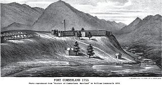
Fort Cumberland was an 18th-century frontier fort at the current site of Cumberland, Maryland, USA. It was an important military and economic center during the French and Indian War (1754–63) and figured significantly in the early career of George Washington.

Glebe was an unincorporated community in Hampshire County, West Virginia, United States. It is situated at the lower mouth of the Trough, a gorge of the South Branch Potomac River, and is about 9.5 miles (15.3 km) southwest of Romney on South Branch River Road. The community received its name from the old stone glebehouse (parsonage) that was constructed there in the late 18th century. The stone house later became the Hampshire County Poor Farm and remains standing. The community of Sector lies directly across the river.

Capon Chapel, also historically known as Capon Baptist Chapel and Capon Chapel Church, is a mid-19th century United Methodist church located near to the town of Capon Bridge, West Virginia, in the United States. Capon Chapel is one of the oldest existing log churches in Hampshire County, along with Mount Bethel Church and Old Pine Church.

Quick is a small unincorporated community in Kanawha County, West Virginia, United States. It is located along Indian Creek Road. The community is where Whitoak Fork and Blue Creek come together and meet. It is also where the abandoned railroad that follows Blue Creek joins the road, and follows it all the way to the community of Hitop, along Pond Fork. Its post office is closed.

Fort Seneca is a census-designated place in Pleasant Township, Seneca County, Ohio, United States. It is located on State Route 53, approximately 6 miles (9.7 km) North of Tiffin. It had a population of 254 in 2010. Although unincorporated, Fort Seneca had a post office, with the ZIP code of 44829 until 1998. The post office was opened on December 15, 1821.
Brownsville is an unincorporated community and census-designated place in Washington County, Maryland, United States, near Gapland in an area known as Pleasant Valley. Its population was 89 as of the 2010 census.
Van Meter State Park is a public recreation area on the Missouri River in Saline County, Missouri. The state park consists of 1,105 acres (447 ha) of hills, ravines, fresh water marsh, fens, and bottomland and upland forests in an area known as "the Pinnacles." The park has several archaeological sites, a cultural center, and facilities for camping, hiking, and fishing. It is managed by the Missouri Department of Natural Resources.

Fort Van Meter — or Fort VanMeter — is a mid-18th century frontier fort in the South Branch Potomac River Valley about 9 miles (14 km) southwest of Romney in Hampshire County, West Virginia, USA. It is located 15 miles (24 km) northeast of Moorefield and about a mile northeast of the former community of Glebe at the northern end of the rugged river gorge known as The Trough.
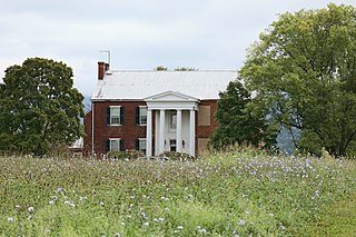
Fort Pleasant — formerly known as Fort Van Meter and Town Fort and still also known as the Isaac Van Meter House — is a historic site located near the unincorporated community of Old Fields about 5 miles north of Moorefield in Hardy County, West Virginia, U.S. Situated on the South Branch Potomac River, a young Colonel George Washington directed a fortification to be built here in 1756 during the escalating hostilities with Native Americans and French known as the French and Indian War. The fierce skirmish known as the Battle of the Trough occurred about a mile and a half away the same year. The existing Federal style house, built just after the American Revolution, was listed on the National Register of Historic Places in 1973.
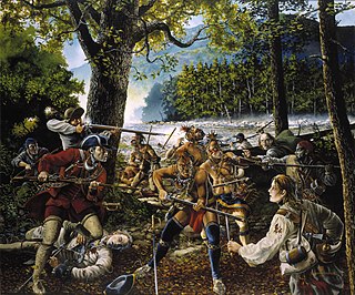
The Battle of the Trough was a skirmish of the early French and Indian War (1754–63) fought between Native Americans and Anglo-American settlers in the valley of the South Branch Potomac River in what is now northern Hardy County, West Virginia, USA.

Buena Vista Farms is a historic home located near Old Fields, Hardy County, West Virginia, USA. It was listed on the National Register of Historic Places in 1985.
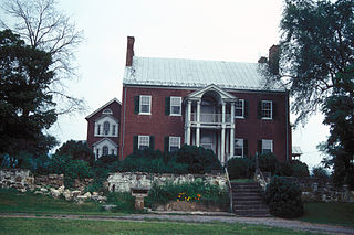
"Willow Wall", also known as McNeill Family House, is a historic home located near Old Fields, Hardy County, West Virginia. It was built in 1811–1812, and is a two-story, "U"-shaped brick dwelling in the Georgian-Tidewater style. It has a double Georgian porch, outlined by Ionic order columns. The two wings have double Palladian windows on the front gable ends. The interior features the French hand-printed wallpaper "The Passing of the Chase." The property was first settled in between 1760 and 1770 by Daniel McNeill. During the American Civil War the McNeill properties were centers of activity for McNeill's Rangers and the Willow Wall residence was used as a hospital for wounded men.

The Garrett VanMeter House is an historic home near Old Fields, Hardy County, West Virginia, USA.

Lewis Magisterial District is one of ten magisterial districts in Mason County, West Virginia, United States. The district was originally established as a civil township in 1863, and converted into a magisterial district in 1872. In 2020, Robinson District was home to 5,635 people.

Chinnabee, also spelled Chinneby or Chinnibee, is an unincorporated community in Talladega County, Alabama, United States.


