
The Cacapon River, located in the Appalachian Mountains of West Virginia's Eastern Panhandle region, is an 81.0-mile-long (130.4 km) shallow river known for its fishing, boating, wildlife, hunting, and wilderness scenery. As part of the Potomac River watershed, it is an American Heritage River.

The National Register of Historic Places in the United States is a register including buildings, sites, structures, districts, and objects. The Register automatically includes all National Historic Landmarks as well as all historic areas administered by the U.S. National Park Service. Since its introduction in 1966, more than 90,000 separate listings have been added to the register.
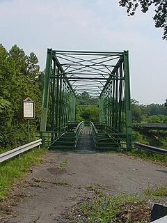
Capon Lake is an unincorporated community in Hampshire County of West Virginia's Eastern Panhandle region. Capon Lake is situated between Yellow Spring and Intermont at the junction of West Virginia Route 259 and Capon Springs Road along the Cacapon River. Capon Springs Run empties into the Cacapon here across from the old Capon Lake Whipple Truss Bridge. Capon Lake takes its name from the Cacapon River's lake-like characteristics there. It was a popular picnic spot for tourists and travelers on the Winchester and Western Railroad.

York River State Park is located near the unincorporated town of Croaker in James City County, Virginia on the south bank of the York River about 10 miles downstream from West Point.

Mother Neff State Park is a 259-acre (105 ha) state park located on the Leon River west of Moody, Texas in Coryell County. The park is part of Mother Neff State Park and F.A.S. 21-B(1) Historic District, which was added to the National Register of Historic Places on October 2, 1992.
Mathias is an unincorporated community along the Lost River in Hardy County in the U.S. state of West Virginia. Mathias lies off West Virginia Route 259. Before the consolidated school of East Hardy High School at Baker, Mathias had its own educational facility, Mathias School, which served grades kindergarten through twelfth.
Institute is an unincorporated community on the Kanawha River in Kanawha County, West Virginia, United States. Interstate 64 and West Virginia Route 25 pass by the community, which has grown to intermingle with nearby Dunbar. As of 2018, the community had a population of 1,489, 54% of whom were African American.
This is a list of the National Register of Historic Places listings in Preston County, West Virginia. This is intended to be a complete list of the properties and districts on the National Register of Historic Places in Preston County, West Virginia. The locations of National Register properties and districts for which the latitude and longitude coordinates are included below, may be seen in an online map.

This is a list of the National Register of Historic Places listings in Fayette County, West Virginia.

This is a list of the National Register of Historic Places listings in Halifax County, Virginia.

This is a list of the National Register of Historic Places listings in Morgan County, West Virginia.

This is a list of the National Register of Historic Places listings in Mason County, West Virginia.

This is a list of the National Register of Historic Places listings in Mineral County, West Virginia.

This is a list of the National Register of Historic Places listings in Barbour County, West Virginia.
The Lost River is a 31.1-mile-long (50.1 km) river in the Appalachian Mountains of Hardy County in West Virginia's Eastern Panhandle region. The Lost River is geologically the same river as the Cacapon River: It flows into an underground channel northeast of McCauley along West Virginia Route 259 at "the Sinks" and reappears near Wardensville as the Cacapon. The source of the Lost River lies south of Mathias near the West Virginia/Virginia border. Along with the Cacapon and North rivers, the Lost River serves as one of the three main segments of the Cacapon River and its watershed.
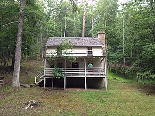
"Lighthorse Harry" Lee Cabin, also known as Lee Cabin, is a historic home located in Lost River State Park, near Mathias, Hardy County, West Virginia. It was built about 1800, and is a two-story, frame and hewn-log structure. It was built by Henry "Light Horse Harry" Lee III (1756-1818) as a summer retreat from the heat of their eastern Virginia home. The property remained in the Lee family until 1879. The State of West Virginia acquired it in the 1930s as a portion of Lost River State Park and the state operates it as a museum.

This is a list of the National Register of Historic Places listings in Boone County, West Virginia.

This is a list of the National Register of Historic Places listings in Raleigh County, West Virginia.
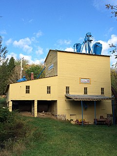
Yellow Spring Mill is a historic grist mill at the junction of West Virginia Route 259 and Cacapon River Road in Yellow Spring, West Virginia. The main building is a three-story wood-frame structure, with a gable roof, clapboard siding, and a foundation of concrete and stone. A single-story ell extends to one side. The property includes as outbuildings two residential cottages and a storage shed, along with two mill ponds and related raceways. The mill was established about 1896, and remained in operation as an economic mainstay of the community until 1990.


