Mathias, West Virginia

Last updated
Mathias, West Virginia
Mathias Church of the Brethren 05.jpg
Church of the Brethren in Mathias
USA West Virginia location map.svg
Red pog.svg
Mathias
Usa edcp location map.svg
Red pog.svg
Mathias
Coordinates: 38°52′40″N78°51′58″W / 38.87778°N 78.86611°W / 38.87778; -78.86611 Coordinates: 38°52′40″N78°51′58″W / 38.87778°N 78.86611°W / 38.87778; -78.86611
Country United States
State West Virginia
County Hardy
Elevation
1,567 ft (478 m)
Time zone UTC-5 (Eastern (EST))
  Summer (DST) UTC-4 (EDT)
GNIS feature ID1555067 [1]

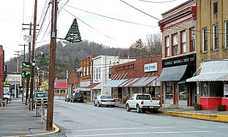
Mathias is an unincorporated community along the Lost River in Hardy County in the U.S. state of West Virginia. Mathias lies off West Virginia Route 259. Before the consolidated school of East Hardy High School at Baker, Mathias had its own educational facility, Mathias School, which served grades Kindergarten through twelfth.

Unincorporated area Region of land not governed by own local government

In law, an unincorporated area is a region of land that is not governed by a local municipal corporation; similarly an unincorporated community is a settlement that is not governed by its own local municipal corporation, but rather is administered as part of larger administrative divisions, such as a township, parish, borough, county, city, canton, state, province or country. Occasionally, municipalities dissolve or disincorporate, which may happen if they become fiscally insolvent, and services become the responsibility of a higher administration. Widespread unincorporated communities and areas are a distinguishing feature of the United States and Canada. In most other countries of the world, there are either no unincorporated areas at all, or these are very rare; typically remote, outlying, sparsely populated or uninhabited areas.

Hardy County, West Virginia County in the United States

Hardy County is a county in the U.S. state of West Virginia. As of the 2010 census, the population was 14,025. Its county seat is Moorefield. The county was created from Hampshire County in 1786 and named for Samuel Hardy, a distinguished Virginian.

U.S. state constituent political entity of the United States

In the United States, a state is a constituent political entity, of which there are currently 50. Bound together in a political union, each state holds governmental jurisdiction over a separate and defined geographic territory and shares its sovereignty with the federal government. Due to this shared sovereignty, Americans are citizens both of the federal republic and of the state in which they reside. State citizenship and residency are flexible, and no government approval is required to move between states, except for persons restricted by certain types of court orders.

Mathias has one bank (Summit Community Bank), one restaurant, a post office, a new garage, one community center, one gas station, as well as Lost River State Park. It was founded by John Mathias [2] and contains his historic homestead, the John Mathias House.

Lost River State Park

Lost River State Park is a state park located in Hardy County, West Virginia near the community of Mathias. The park encompasses 3,712 acres (15.02 km2) managed by the West Virginia Division of Natural Resources. Despite the name of the park, it does not abut the Lost River; it lies about 2.3 miles (3.7 km) west of the river.

John Mathias House United States national historic site

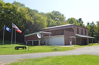
John Mathias House, also known as the Mathias Homestead, is a historic home located at Mathias, Hardy County, West Virginia. It consists of two sections, one built about 1797 and the second about 1825. The two hewn-log sections are joined by a frame "dog trot," or what has been referred to locally as the "entry." The older section is two stories with a double porch and lightly taller than the newer section. It was home to the Mathias family for 165 years before being deeded to the Mathias Civic Center Association in 1974.

Climate

The climate in this area is characterized by hot, humid summers and generally mild to cool winters. According to the Köppen Climate Classification system, Mathias has a humid subtropical climate, abbreviated "Cfa" on climate maps. [3]

Humid subtropical climate category in the Köppen climate classification system

A humid subtropical climate is a zone of climate characterized by hot and humid summers, and cool to mild winters. These climates normally lie on the southeast side of all continents, generally between latitudes 25° and 40° and are located poleward from adjacent tropical climates. While many subtropical climates tend to be located at or near coastal locations, in some cases they extend inland, most notably in China and the United States, where they exhibit more pronounced seasonal variations and sharper contrasts between summer and winter, as part of a gradient between the more tropical climates of the southern coasts of these countries and the more continental climates of China and the United States’ northern and central regions.

Related Research Articles

Glenville, West Virginia Town in West Virginia, United States

Glenville is a town in and the county seat of Gilmer County, West Virginia, United States, along the Little Kanawha River. The population was 1,537 at the 2010 census. It is the home of Glenville State College.

Moorefield, West Virginia Town in West Virginia, United States

Moorefield is a town in Hardy County, West Virginia, USA. Moorefield is the county seat of Hardy County. It was originally chartered in 1777 and named for Conrad Moore, who owned the land upon which the town was laid out. The population was 2,544 at the 2010 census. Moorefield is located at the confluence of the South Branch Potomac River and the South Fork South Branch Potomac River.

Clendenin, West Virginia Town in West Virginia, United States

Clendenin is a town in Kanawha County, West Virginia along the Elk River. The population was 1,227 at the 2010 census.

West Virginia Route 259 is a state highway in the U.S. state of West Virginia. The state highway runs 45.6 miles (73.4 km) from the Virginia state line near Mathias north to the Virginia state line at High View. At both termini, the road continues as Virginia State Route 259. WV 259 passes through Hardy and Hampshire counties and runs concurrently with WV 55 on Corridor H between Baker and Wardensville.

Shenandoah Junction, West Virginia Census-designated place in West Virginia, United States

Shenandoah Junction is a census-designated place (CDP) in Jefferson County in the U.S. state of West Virginia's Eastern Panhandle. As of the 2010 census, Shenandoah Junction had a population of 703. It is located between Kearneysville and Charles Town off WV 9. Shenandoah Junction is home to Jefferson High School and West Virginia's oldest surviving wood frame structure, the Peter Burr House, built around 1751. The land where Shenandoah Junction was built was part of the 392 acres (1.59 km2) granted by Lord Fairfax to Lewis Neil. The town was originally called Neil's, but the name was changed to Shenandoah Junction in 1881.

Uneeda, West Virginia Unincorporated community in West Virginia, United States

Uneeda is an unincorporated community on the Pond Fork River in Boone County in the U.S. state of West Virginia. The town lies along West Virginia Route 85.

Lightfoot, Virginia human settlement in Virginia, United States of America

Lightfoot is an unincorporated community which straddles the James City–York county border, west of Williamsburg, in the U.S. state of Virginia.

Palmyra, Virginia Census-designated place in Virginia, United States

Palmyra is a census-designated place (CDP) in and the county seat of Fluvanna County, Virginia, United States. The population as of the 2010 census was 104. Palmyra lies on the eastern bank of the Rivanna River along U.S. Route 15. The ZIP code for Palmyra and surrounding rural land is 22963.

Randolph, Virginia human settlement in Virginia, United States of America

Randolph, formerly called Roanoke and Talcott, is a small unincorporated community in Charlotte County, Virginia, United States, near the Staunton River. Its elevation is 354 feet. The community is the home of Staunton River Battlefield State Park.

Hacker Valley, West Virginia Unincorporated community in West Virginia, United States

Hacker Valley is an unincorporated community in northern Webster County, West Virginia, USA, along the Left Fork of the Holly River. Its ZIP Code is 26222.

Belva, West Virginia Census-designated place in West Virginia, United States

Belva is an unincorporated community and census-designated place in west Nicholas County and north Fayette County, West Virginia, United States; while the CDP only includes the Nicholas County portion, the Fayette County portion is considered part of the community. The town is situated at the bottomland surrounding the convergence of Bells Creek with Twentymile Creek and, subsequently, Twenty Mile Creek with the Gauley River. Belva is also the location of the convergence of two state highways: West Virginia Route 16 and West Virginia Route 39.

Neola, West Virginia Unincorporated community in West Virginia, United States

Neola is an unincorporated community in northeastern Greenbrier County, West Virginia, United States. It lies along West Virginia Route 92 north of the city of White Sulphur Springs. Its elevation is 2,037 feet (621 m).

Rock View, West Virginia Unincorporated community in West Virginia, United States

Rock View is an unincorporated community in Wyoming County, West Virginia, United States.

Hico, West Virginia Census-designated place in West Virginia, United States

Hico is a census-designated place (CDP) in Fayette County, West Virginia, United States. Hico is located at the junction of U.S. Route 19 and U.S. Route 60 7 miles (11 km) northeast of Fayetteville. Hico has a post office with ZIP code 25854. As of the 2010 census, its population was 272.

Crabapple, Texas Unincorporated community in Texas, United States

Crabapple, Texas is an unincorporated farming and ranching community 10.5 miles (16.9 km) north of Fredericksburg in Gillespie County, Texas located on Crabapple Creek, about halfway between Fredericksburg and Enchanted Rock State Park at an elevation of 1,775 feet. The school was designated a Recorded Texas Historic Landmark number 10022 in 1994. The school was added to the National Register of Historic Places in Texas on May 6, 2005, NRHP Reference #:05000390.

Procious, West Virginia Unincorporated community in West Virginia, United States

Procious is an unincorporated community in Clay County, West Virginia, United States. Procious is located on the Elk River and West Virginia Route 4, 7 miles (11 km) west-northwest of Clay. Procious has a post office with ZIP code 25164.

Evington, Virginia Unincorporated community in Virginia, United States

Evington is an unincorporated community in Campbell County, Virginia, United States. Evington is located along Virginia State Route 24, west of U.S. Highway 29, southwest of Lynchburg.

Lost River (Cacapon River tributary) river in the United States of America

The Lost River is a 31.1-mile-long (50.1 km) river in the Appalachian Mountains of Hardy County in West Virginia's Eastern Panhandle region. The Lost River is geologically the same river as the Cacapon River: It flows into an underground channel northeast of McCauley along West Virginia Route 259 at "the Sinks" and reappears near Wardensville as the Cacapon. The source of the Lost River lies south of Mathias near the West Virginia/Virginia border. Along with the Cacapon and North rivers, the Lost River serves as one of the three main segments of the Cacapon River and its watershed.

West Augusta, Virginia Unincorporated community in Virginia, United States

West Augusta is an unincorporated community in Augusta County, Virginia, United States. West Augusta is located at the intersection of U.S. Route 250 and Virginia State Route 629. The source of the Calfpasture River, which flows through West Augusta, is located near the community to the north.

References

  1. U.S. Geological Survey Geographic Names Information System: Mathias, West Virginia
  2. Kenny, Hamill (1945). West Virginia Place Names: Their Origin and Meaning, Including the Nomenclature of the Streams and Mountains. Piedmont, WV: The Place Name Press. p. 406.
  3. Climate Summary for Mathias, West Virginia