
Rockland County is the southernmost county on the west side of the Hudson River in the U.S. state of New York, part of the New York City Metropolitan Statistical Area. The county's population, as of the 2010 census, was 311,687, increasing by 5.5% to a 2017 Census estimate of 328,868, making it the third-most densely populated county outside New York City within New York State. The county seat is New City. Rockland County is a suburb of New York City that borders the boroughs about 9 miles northwest of the city at their closest points, and is accessible via the New York State Thruway, after 10 exits. The name derives from "rocky land", as the area has been aptly described.

The Eastern Panhandle is the eastern of the two panhandles in the U.S. state of West Virginia. It is a small stretch of territory in the northeast of the state, bordering Maryland and Virginia. Some sources and regional associations only identify the Eastern Panhandle as being composed of Morgan, Berkeley, and Jefferson Counties. Berkeley and Jefferson Counties are geographically located in the Shenandoah Valley. West Virginia is unusual in having two panhandles, the Eastern Panhandle and the Northern Panhandle.
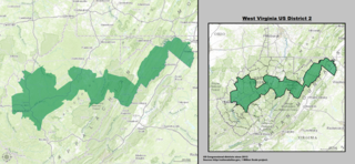
West Virginia's 2nd congressional district stretches from the Ohio River border with Ohio to the Potomac River border with Maryland and the border with Virginia. It includes the capital city of Charleston and the rapidly growing residential communities of West Virginia's Eastern Panhandle and Potomac Highlands regions connected by a narrow strip of nearly unpopulated counties. It has been accurately described as 20 miles wide and 300 miles long.
Baker Mountain is a mountain ridge in southeastern Hampshire County, West Virginia. The mountain runs southwest northeast between Yellow Spring and the Hardy County line. Baker Mountain is flanked to its east by the Cacapon River with West Virginia Route 259 running parallel between the two. Its forests were once used as a major source of timber for the Baltimore and Ohio Railroad's rail ties. For this reason, the Winchester and Western Railroad was constructed through the Capon Valley in the 1920s to haul the timber harvested in the region to Winchester, Virginia for railroad tie production. The communities of Capon Lake and Intermont lie at the foot of Baker Mountain on the Cacapon.

Lost River State Park is a state park located in Hardy County, West Virginia near the community of Mathias. The park encompasses 3,712 acres (15.02 km2) managed by the West Virginia Division of Natural Resources. Despite the name of the park, it does not abut the Lost River; it lies about 2.3 miles (3.7 km) west of the river.

Arkansas is an unincorporated community in Hardy County, West Virginia. It is located on Arkansaw Road (County Route 3/2 off West Virginia Route 29.
Fisher is an unincorporated community on the South Branch Potomac River in Hardy County, West Virginia. It lies west of Moorefield. The precise origin of its name is unclear. It may be named generally for the Fisher family that lived in its vicinity, or more specifically for George Fisher, whose family lived on the South Branch approximately one mile due south of Fisher.

Baker is an unincorporated community on the Lost River in Hardy County, West Virginia, United States. Baker is located at the intersection of West Virginia Route 259 and West Virginia Route 55. The ZCTA population for Baker's ZIP Code was 1,262 at the 2000 census.
Milam is an unincorporated community on the South Fork South Branch Potomac River in southern Hardy County, West Virginia. Milam is located along County Route 7. Originally known as Wine Spring, the community's name was changed to Milam in 1898.
Mathias is an unincorporated community along the Lost River in Hardy County in the U.S. state of West Virginia. Mathias lies off West Virginia Route 259. Before the consolidated school of East Hardy High School at Baker, Mathias had its own educational facility, Mathias School, which served grades Kindergarten through twelfth.
McNeill is an unincorporated community in Hardy County, West Virginia, United States. It lies near the South Branch Potomac River on Trough Road.
Perry is an unincorporated community in Hardy County, West Virginia, United States. Perry lies in the Trout Run Valley of eastern Hardy County.
Rockland is the name of several communities in the U.S. state of West Virginia.
Eckman is an unincorporated community in McDowell County, West Virginia. Eckman is located along U.S. Route 52 to the west of the city of Keystone. Eckman used to be known as Shawnee Camp.
Trout Run is an 18.5-mile-long (29.8 km) tributary of the Cacapon River, belonging to the Potomac River and Chesapeake Bay watersheds. The stream is located in Hardy County in West Virginia's Eastern Panhandle. Trout Run rises between Devils Hole Mountain and Great North Mountain near the Virginia state line in the George Washington National Forest. The stream empties into the Cacapon River at Wardensville.
Rockland is an unincorporated community in Greenbrier County, West Virginia, United States. Rockland is located on the Greenbrier River 3 miles (4.8 km) southwest of Ronceverte.
Hardy is an unincorporated community in Mercer County, West Virginia, United States. Hardy is 5.5 miles (8.9 km) southeast of Princeton.

The North River is a tributary of the Cacapon River, belonging to the Potomac River and Chesapeake Bay watersheds. The river is located in Hampshire and Hardy counties in the U.S. state of West Virginia's Eastern Panhandle. The mouth of the North River into the Cacapon is located at Forks of Cacapon. From its headwaters to its mouth, the North River spans 52.4 miles (84.3 km) in length.


