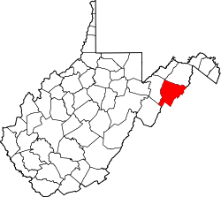
Furnace, West Virginia | |
---|---|
Unincorporated community | |
Coordinates: 39°1′57″N78°36′10″W / 39.03250°N 78.60278°W Coordinates: 39°1′57″N78°36′10″W / 39.03250°N 78.60278°W | |
Country | United States |
State | West Virginia |
County | Hardy |
Elevation | 1,332 ft (406 m) |
Time zone | Eastern (EST) (UTC-5) |
• Summer (DST) | EDT (UTC-4) |
GNIS ID | 1556839 [1] |
Furnace was an unincorporated community in Hardy County, West Virginia.
In law, an unincorporated area is a region of land that is not governed by a local municipal corporation; similarly an unincorporated community is a settlement that is not governed by its own local municipal corporation, but rather is administered as part of larger administrative divisions, such as a township, parish, borough, county, city, canton, state, province or country. Occasionally, municipalities dissolve or disincorporate, which may happen if they become fiscally insolvent, and services become the responsibility of a higher administration. Widespread unincorporated communities and areas are a distinguishing feature of the United States and Canada. In most other countries of the world, there are either no unincorporated areas at all, or these are very rare; typically remote, outlying, sparsely populated or uninhabited areas.
Hardy County is a county in the U.S. state of West Virginia. As of the 2010 census, the population was 14,025. Its county seat is Moorefield. The county was created from Hampshire County in 1786 and named for Samuel Hardy, a distinguished Virginian.
West Virginia is a state located in the Appalachian region in the Southern United States and is also considered to be a part of the Middle Atlantic States. It is bordered by Pennsylvania to the north, Maryland to the east and northeast, Virginia to the southeast, Kentucky to the southwest, and Ohio to the northwest. West Virginia is the 41st largest state by area, and is ranked 38th in population. The capital and largest city is Charleston.
A bloomery is a type of furnace once used widely for smelting iron from its oxides. The bloomery was the earliest form of smelter capable of smelting iron. A bloomery's product is a porous mass of iron and slag called a bloom. This mix of slag and iron in the bloom is termed sponge iron, which is usually consolidated and further forged into wrought iron. The bloomery has now largely been superseded by the blast furnace, which produces pig iron.
The George Washington and Jefferson National Forests are U.S. National Forests that combine to form one of the largest areas of public land in the Eastern United States. They cover 1.8 million acres (7,300 km2) of land in the Appalachian Mountains of Virginia, West Virginia, and Kentucky. Approximately 1 million acres (4,000 km2) of the forest are remote and undeveloped and 139,461 acres (564 km2) have been designated as wilderness areas, which eliminates future development.
An ironworks or iron works is a building or site where iron is smelted and where heavy iron and steel products are made. The term is both singular and plural, i.e. the singular of ironworks is ironworks.
Furnace Creek may refer to:
West Virginia Route 127 is an east–west state highway located in northeast West Virginia. The western terminus is at West Virginia Route 29 near Forks of Cacapon in Hampshire County. The eastern terminus is at the Virginia state line west of U.S. Route 522 and east of Good, where WV 127 continues eastward as State Route 127.
Catoctin Creek is a 14.1-mile-long (22.7 km) tributary of the Potomac River in Loudoun County, Virginia, with a watershed of 59,000 acres (240 km2). Agricultural lands make up 67 percent and forests 30 percent of Catoctin Creek's watershed. It is the main drainage system for the northern Loudoun Valley, including all of the Catoctin Valley.
Bloomery is an unincorporated community in Hampshire County in the U.S. state of West Virginia. Bloomery is located along the Bloomery Pike, northwest of Winchester, Virginia. According to the 2000 census, the Bloomery community has a population of 321.
Devil's Backbone State Forest is a 558-acre (226 ha) state forest in Shenandoah County, Virginia. It lies on the slope of North Mountain in the drainage area of Cedar Creek near Star Tannery west of Strasburg. The forest was established by a grant by John and Bernice Hoffman, who owned the land since 1950.
Coopers Rock State Forest is a 12,747-acre (52 km2) state forest in Monongalia and Preston counties in the U.S. state of West Virginia. Its southern edge abuts Cheat Lake and the canyon section of Cheat River, a popular whitewater rafting river in the eastern United States.
A furnace is a device for high-temperature heating. Furnace may also refer to:
Newport is an unincorporated community in Page County, Virginia, United States. Newport is located on the Shenandoah River and U.S. Route 340 5 miles (8.0 km) west of Stanley.
Boom Furnace is an unincorporated community in Pulaski County, in the U.S. state of Virginia. The name of the community derives from a nearby furnace that made loud booming sounds when started. The furnace began operation in 1882 and, when it ended operations in 1906, was the last "cold blast, water power charcoal" furnace in Virginia. The furnace still stands today.
Henry Clay Furnace is a historic iron furnace located in Cooper's Rock State Forest near Cheat Neck, Monongalia County, West Virginia. It was built between 1834 and 1836, and is a 30-foot square, 30 feet high stone structure in the shape of a truncated pyramid. The furnace may have continued to operate until 1868 when all the Cheat River iron works ceased production. It is among the ten or more abandoned iron furnaces still existing in northern West Virginia.
Virginia Furnace, also known as Muddy Creek Furnace and Josephine Furnace, is a historic water powered blast furnace and national historic district located near Albright, Preston County, West Virginia. The district encompasses three contributing structures and one contributing site. The furnace was built in 1854, and was a "charcoal" iron furnace used to smelt iron. It is constructed of cut sandstone, and forms a truncated pyramid measuring approximately 34 feet square in plan and rising about 30 feet. The district includes the nearby wheel pit, blast machinery, and salamander. The furnace remained in operation until the 1890s, and was the last "charcoal" iron furnace to cease operating in northern West Virginia. In 1933, the Virginia Furnace was acquired by the Kingswood Chapter of the Daughters of the American Revolution who created a roadside park at the furnace site.
Clinton Furnace is an unincorporated community in Monongalia County, West Virginia.
Rock Forge is an unincorporated community in Monongalia County, West Virginia.
Valley Furnace is an unincorporated community in Barbour County, West Virginia.
West Fork Furnace is a historic iron furnace and national historic district located near Floyd, Floyd County, Virginia. The district includes structural, landscape and archaeological components of a small and well preserved mid-19th-century iron furnace built about 1853. The components consist of the furnace, retaining wall, staging area, head race, wheel pit, tail race, and East Prong of Furnace Creek. The furnace remained in operation until 1855.
Ervin George Bailey was an American mechanical engineer, founding president of Bailey Meter Company, manufacturer of industrial meters and controls, and inventor. He was recipient of the 1942 ASME Medal, and served as 67th president of the American Society of Mechanical Engineers.
This article about a location in Hardy County, West Virginia is a stub. You can help Wikipedia by expanding it. |