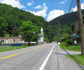
Purgitsville is an unincorporated community in Hampshire County in the U.S. state of West Virginia. According to the 2000 census, the ZCTA for Purgitsville had a population of 813. Purgitsville is located on U.S. Highway 220/West Virginia Route 28 at its intersection with Huffman Road south of Junction. An elementary school, Mill Creek Elementary, was open here until 1993 when it was consolidated with Romney Elementary.
The city of Romney, Virginia traded hands between the Union Army and Confederate States Army no fewer than 10 times during the American Civil War, assuming the occupying force spent at least one night in the town. The story of the small town is emblematic of the many military campaigns that swept through western Virginia and, later, the new state of West Virginia.

Ennis is an unincorporated community in McDowell County, West Virginia, United States. Ennis lies on U.S. Route 52 west of Switchback.

Gilliam is an unincorporated community on the North Fork River in McDowell County, West Virginia, United States. It lies between Algoma and Rolfe along County Route 17.

Isaban is an unincorporated community located on Fourpole Creek, in McDowell and Mingo counties in the U.S. state of West Virginia.

McNeill's Rangers was an independent Confederate military force commissioned under the Partisan Ranger Act (1862) by the Confederate Congress during the American Civil War. The 210 man unit was formed from Company E of the 18th Virginia Cavalry and the First Virginia Partisan Rangers. After the repeal of the Act on February 17, 1864, McNeill's Rangers was one of two partisan forces allowed to continue operation, the other being 43rd Battalion Virginia Cavalry. Both of these guerrilla forces operated in the western counties of Virginia and West Virginia. The Rangers were known to exercise military discipline when conducting raids. However, many Union generals considered Captain John Hanson McNeill (1815–1864) and his men to be "bushwhackers," not entitled to protection when captured, as was the case with other prisoners of war.

Smoot is an unincorporated community in western Greenbrier County, West Virginia, United States. It lies south of the interchange of Interstate 64 and U.S. Route 60 northwest of the city of Lewisburg, the county seat of Greenbrier County. Its elevation is 2,480 feet (756 m). Although it is unincorporated, it has a post office, with the ZIP code of 24977.

Smithville is an unincorporated community in southern Ritchie County, West Virginia, USA. It lies along West Virginia Route 47 south of the town of Harrisville, the county seat of Ritchie County. Its elevation is 686 feet (209 m). Although it is unincorporated, it has a post office, with the ZIP code of 26178.

Powhatan is an unincorporated community in McDowell County, West Virginia located approximately one mile from Northfork, West Virginia.

Six is an unincorporated community in McDowell County, West Virginia, United States. Six is located on West Virginia Route 16 5 miles (8.0 km) southwest of Welch.

John Hanson "Hanse" McNeill was a Confederate soldier who served as a Captain in the Confederate Army during the American Civil War. He led McNeill's Rangers, an independent irregular Confederate military company commissioned under the Partisan Ranger Act.

Leckie is an unincorporated community in McDowell County, West Virginia, United States. Leckie is 1 mile (1.6 km) northeast of Anawalt.

Twin Branch is an unincorporated community in McDowell County, West Virginia, United States. Twin Branch is 1 mile (1.6 km) west-southwest of Davy. It was founded by Henry Ford as a mining community.

McDowell is an unincorporated community in McDowell County, West Virginia, United States. McDowell is 3.5 miles (5.6 km) east-southeast of Northfork.

Lex is an unincorporated community in McDowell County, West Virginia, United States. Lex is located on West Virginia Route 80 1.3 miles (2.1 km) north of Bradshaw.

McAlpin is an unincorporated community in Raleigh County, West Virginia, United States. McAlpin is located on County Route 30 and Winding Gulf 1.9 miles (3.1 km) west-southwest of Sophia.

Peapatch is an unincorporated community in Buchanan County, Virginia and McDowell County, West Virginia.

McCreery is an unincorporated community in Raleigh County, West Virginia.

Prudence is an unincorporated community and coal town in Fayette County, West Virginia.

MacDonald is an unincorporated community and coal town in Fayette County, West Virginia, United States.


