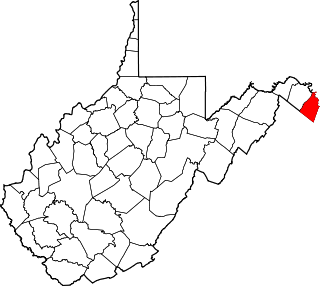
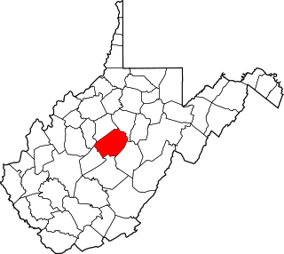
[3] Name on the Register [4] Image Date listed [5] Location City or town Description 1 Abell-Kilbourn House Abell-Kilbourn House November 21, 1994 (# 94001290 1018 Winchester Ave. 39°26′48″N 77°58′47″W / 39.44676°N 77.97981°W / 39.44676; -77.97981 (Abell-Kilbourn House ) Martinsburg 2 Apollo Theatre Apollo Theatre October 11, 1979 (# 79002569 128 E. Martin St 39°27′29″N 77°57′45″W / 39.458056°N 77.9625°W / 39.458056; -77.9625 (Apollo Theatre ) Martinsburg 3 Ar-Qua Springs Ar-Qua Springs December 12, 1976 (# 76001929 County Route 37 39°25′27″N 78°02′18″W / 39.42415°N 78.03836°W / 39.42415; -78.03836 (Ar-Qua Springs ) Arden 4 Aspen Hall Aspen Hall December 10, 1980 (# 80004882 405 Boyd Ave. [6] 39°27′47″N 77°57′54″W / 39.463°N 77.965°W / 39.463; -77.965 (Aspen Hall ) Martinsburg 5 Baldwin-Grantham House Baldwin-Grantham House November 21, 1994 (# 94001296 County Route 18 east of Shanghai 39°26′14″N 78°07′08″W / 39.437222°N 78.118889°W / 39.437222; -78.118889 (Baldwin-Grantham House ) Shanghai 6 Baltimore and Ohio and Related Industries Historic District Baltimore and Ohio and Related Industries Historic District December 10, 1980 (# 80004415 Roughly bounded by the Baltimore & Ohio railroad line from the southern side of the Burke St. underpass to the northern side of the B&O and Pennsylvania Railroad bridge 39°27′43″N 77°57′45″W / 39.461944°N 77.9625°W / 39.461944; -77.9625 (Baltimore and Ohio and Related Industries Historic District ) Martinsburg 7 Baltimore and Ohio Railroad Martinsburg Shops Baltimore and Ohio Railroad Martinsburg Shops July 31, 2003 (# 03001045 300 E. Martin St. 39°27′39″N 77°57′34″W / 39.460833°N 77.959444°W / 39.460833; -77.959444 (Baltimore and Ohio Railroad Martinsburg Shops ) Martinsburg 8 William Boggs Farm Upload image March 7, 2001 (# 00001310 WV 7 39°32′25″N 78°01′32″W / 39.540278°N 78.025556°W / 39.540278; -78.025556 (William Boggs Farm ) Hedgesville 9 Boomtown Historic District Boomtown Historic District December 10, 1980 (# 80004414 Roughly along Winchester Ave. to Arden Rd., W. King St. to Red Hill Rd., W. Stephen, W. Addition St., and Raleigh Sts. 39°27′06″N 77°58′44″W / 39.451667°N 77.978889°W / 39.451667; -77.978889 (Boomtown Historic District ) Martinsburg 10 Boyd Avenue Historic District Boyd Avenue Historic District August 3, 2007 (# 07000781 Eastern and western sides of Boyd Ave., north of Queen St. 39°27′50″N 77°57′53″W / 39.464°N 77.96475°W / 39.464; -77.96475 (Boyd Avenue Historic District ) Martinsburg 11 Boydville Boydville October 15, 1970 (# 70000649 601 S. Queen St. 39°27′05″N 77°58′05″W / 39.451389°N 77.968056°W / 39.451389; -77.968056 (Boydville ) Martinsburg 12 Boydville Historic District Boydville Historic District December 10, 1980 (# 80004413 Roughly bounded by W. Stephen, S. Spring, and S. Queen Sts., including the grounds of Boydville 39°27′06″N 77°58′01″W / 39.451667°N 77.966944°W / 39.451667; -77.966944 (Boydville Historic District ) Martinsburg 13 Thomas Brown House Thomas Brown House January 16, 1986 (# 86000202 County Route 30 39°23′40″N 78°02′55″W / 39.394444°N 78.048611°W / 39.394444; -78.048611 (Thomas Brown House ) Inwood 14 Bunker Hill Historic District Bunker Hill Historic District December 10, 1980 (# 80004412 Junction of U.S. Route 11 and WV 26 39°19′56″N 78°03′13″W / 39.332222°N 78.053611°W / 39.332222; -78.053611 (Bunker Hill Historic District ) Bunker Hill 15 James Nathanial Burwell House James Nathanial Burwell House May 16, 1991 (# 91000553 East of U.S. Route 11 , north of West Virginia state line 39°17′36″N 78°04′27″W / 39.293333°N 78.074167°W / 39.293333; -78.074167 (James Nathanial Burwell House ) Ridgeway 16 Campbellton Campbellton December 10, 1980 (# 80004411 Address Unknown 39°24′20″N 78°04′16″W / 39.405556°N 78.071111°W / 39.405556; -78.071111 (Campbellton ) Gerrardstown 17 Citizens National Bank Upload image August 29, 2023 (# 100009139 110 West King St. 39°27′23″N 77°57′52″W / 39.4564°N 77.9645°W / 39.4564; -77.9645 (Citizens National Bank ) Martinsburg 18 Clary's Mountain Historic District Clary's Mountain Historic District April 15, 2004 (# 04000314 Hammond's Mill Rd. 39°33′25″N 77°59′22″W / 39.556944°N 77.989444°W / 39.556944; -77.989444 (Clary's Mountain Historic District ) Hedgesville 19 Edward Colston House Edward Colston House May 1, 2003 (# 03000347 1598 Tice Rd. 39°35′26″N 77°55′15″W / 39.590556°N 77.920833°W / 39.590556; -77.920833 (Edward Colston House ) Falling Waters 20 Continental Clay Brick Plant Continental Clay Brick Plant December 10, 1980 (# 80004439 Southeast of Martinsburg on WV 9 39°25′59″N 77°57′31″W / 39.433056°N 77.958611°W / 39.433056; -77.958611 (Continental Clay Brick Plant ) Martinsburg 21 Cool Spring Farm Cool Spring Farm November 21, 1994 (# 94001292 Runnymede Rd. (WV 26 ) south of Gerrardstown 39°19′53″N 78°06′23″W / 39.331389°N 78.106389°W / 39.331389; -78.106389 (Cool Spring Farm ) Gerrardstown 22 Samuel Cunningham House Samuel Cunningham House December 12, 1976 (# 76001930 Southeast of Hedgesville off WV 9 39°31′45″N 77°58′46″W / 39.529167°N 77.979444°W / 39.529167; -77.979444 (Samuel Cunningham House ) Hedgesville 23 Darkesville Historic District Darkesville Historic District December 10, 1980 (# 80004410 U.S. Route 11 at Middle Creek 39°22′27″N 78°01′25″W / 39.374167°N 78.023611°W / 39.374167; -78.023611 (Darkesville Historic District ) Darkesville 24 Charles Downs II House Charles Downs II House May 17, 1991 (# 91000554 County Route 1, west of U.S. Route 11 39°34′19″N 77°53′36″W / 39.571944°N 77.893333°W / 39.571944; -77.893333 (Charles Downs II House ) Marlowe 25 Downtown Martinsburg Historic District Downtown Martinsburg Historic District December 10, 1980 (# 80004416 Roughly bounded by W. Race, Water, Stephen, and Charles Sts. 39°27′28″N 77°57′59″W / 39.457778°N 77.966389°W / 39.457778; -77.966389 (Downtown Martinsburg Historic District ) Martinsburg 26 John Drinker House John Drinker House December 10, 1980 (# 80004409 Sam Mason Rd. 39°19′06″N 78°04′48″W / 39.318333°N 78.08°W / 39.318333; -78.08 (John Drinker House ) Bunker Hill 27 East Martinsburg Historic District East Martinsburg Historic District December 10, 1980 (# 80004417 Roughly bounded by the Baltimore & Ohio railroad right-of-way, N. Queen St., Moler Ave., and High St. 39°27′40″N 77°57′19″W / 39.461111°N 77.955278°W / 39.461111; -77.955278 (East Martinsburg Historic District ) Martinsburg 28 Edgewood Edgewood December 10, 1980 (# 80004431 Address Unknown 39°19′49″N 78°03′29″W / 39.330278°N 78.058056°W / 39.330278; -78.058056 (Edgewood ) Bunker Hill 29 John Evans House John Evans House March 22, 2006 (# 06000168 2298 Winchester Ave. 39°25′44″N 77°59′17″W / 39.428889°N 77.988056°W / 39.428889; -77.988056 (John Evans House ) Martinsburg 30 Faraway Farm Upload image December 10, 1980 (# 80004432 WV 8 39°32′55″N 77°56′23″W / 39.548611°N 77.939722°W / 39.548611; -77.939722 (Faraway Farm ) Martinsburg 31 Federal Aviation Administration Records Center Federal Aviation Administration Records Center September 10, 1974 (# 74001995 300 W. King St. 39°27′55″N 77°58′00″W / 39.46537°N 77.96666°W / 39.46537; -77.96666 (Federal Aviation Administration Records Center ) Martinsburg 32 Teter Myers French House Teter Myers French House December 10, 1980 (# 80004434 Junction of Routes 1 and 3 39°33′57″N 77°58′00″W / 39.565833°N 77.966667°W / 39.565833; -77.966667 (Teter Myers French House ) Hedgesville 33 Gerrardstown Historic District Gerrardstown Historic District August 5, 1991 (# 91001008 Roughly along WV 51 and Virginia Line Rd. 39°22′07″N 78°05′51″W / 39.368611°N 78.0975°W / 39.368611; -78.0975 (Gerrardstown Historic District ) Gerrardstown 34 Washington Gold House Washington Gold House January 12, 1984 (# 84003470 South of Gerrardstown on County Route 51/2 39°21′12″N 78°06′35″W / 39.353333°N 78.109722°W / 39.353333; -78.109722 (Washington Gold House ) Gerrardstown 35 Green Hill Cemetery Historic District Green Hill Cemetery Historic District December 10, 1980 (# 80004433 486 E. Burke St. 39°27′13″N 77°57′20″W / 39.453611°N 77.955556°W / 39.453611; -77.955556 (Green Hill Cemetery Historic District ) Martinsburg 36 Harlan Spring Historic District Harlan Spring Historic District December 10, 1980 (# 80004435 Harlan Spring 39°32′59″N 77°57′21″W / 39.549722°N 77.955833°W / 39.549722; -77.955833 (Harlan Spring Historic District ) Hedgesville 37 Harmony Cemetery Harmony Cemetery December 10, 1980 (# 80004436 Route 1/1 39°35′13″N 77°52′54″W / 39.586944°N 77.881667°W / 39.586944; -77.881667 (Harmony Cemetery ) Marlowe 38 Hays-Pitzer House Upload image November 21, 1994 (# 94001294 Middle Creek Rd. (WV 45 ) north of Inwood 39°25′00″N 78°03′53″W / 39.416667°N 78.064722°W / 39.416667; -78.064722 (Hays-Pitzer House ) Martinsburg 39 Hays-Gerrard House Hays-Gerrard House September 16, 1985 (# 85002409 Congress St. 39°22′10″N 78°05′50″W / 39.369444°N 78.097222°W / 39.369444; -78.097222 (Hays-Gerrard House ) Gerrardstown 40 Hedges Chapel Hedges Chapel December 12, 2002 (# 02001520 668 Mountain Lake Rd. 39°33′27″N 78°05′31″W / 39.5575°N 78.091944°W / 39.5575; -78.091944 (Hedges Chapel ) Hedgesville 41 Decatur Hedges House Decatur Hedges House January 12, 1984 (# 84003473 WV 9 39°30′48″N 77°58′20″W / 39.513333°N 77.972222°W / 39.513333; -77.972222 (Decatur Hedges House ) Hedgesville 42 Owen Tudor Hedges House Owen Tudor Hedges House November 21, 1994 (# 94001293 County Route 8 east of Hedgesville 39°32′22″N 77°56′44″W / 39.539444°N 77.945556°W / 39.539444; -77.945556 (Owen Tudor Hedges House ) Hedgesville 43 Samuel Hedges House Upload image December 12, 1976 (# 76001931 County Route 9/10 39°31′40″N 77°59′52″W / 39.527778°N 77.997778°W / 39.527778; -77.997778 (Samuel Hedges House ) Hedgesville 44 Hedges-Lemen House Hedges-Lemen House May 2, 1991 (# 91000556 County Route 4, 0.7 miles north of its junction with WV 9 39°32′31″N 77°58′47″W / 39.541944°N 77.979722°W / 39.541944; -77.979722 (Hedges-Lemen House ) Hedgesville 45 Hedges-Robinson-Myers House Hedges-Robinson-Myers House December 10, 1980 (# 80004418 Route 3 39°33′27″N 77°58′27″W / 39.5575°N 77.974167°W / 39.5575; -77.974167 (Hedges-Robinson-Myers House ) Hedgesville 46 Hedgesville Historic District Hedgesville Historic District December 10, 1980 (# 80004419 Roughly bounded by N. and S. Mary St., and E. and W. Main St. 39°33′12″N 77°59′39″W / 39.553333°N 77.994167°W / 39.553333; -77.994167 (Hedgesville Historic District ) Hedgesville 47 George Washington Hollida House George Washington Hollida House February 11, 2004 (# 04000031 4781 Scabble Rd. 39°29′03″N 77°50′02″W / 39.484167°N 77.833889°W / 39.484167; -77.833889 (George Washington Hollida House ) Shepherdstown 48 Hughes-Cunningham House Hughes-Cunningham House July 8, 1985 (# 85001518 Harlan Springs Rd. 39°32′10″N 77°57′38″W / 39.536111°N 77.960556°W / 39.536111; -77.960556 (Hughes-Cunningham House ) Hedgesville 49 Jones Mill Run Historic District Jones Mill Run Historic District December 10, 1980 (# 80004421 Address Unknown 39°29′15″N 77°49′44″W / 39.4875°N 77.828889°W / 39.4875; -77.828889 (Jones Mill Run Historic District ) Martinsburg 50 Kearfott-Bane House Kearfott-Bane House July 8, 1985 (# 85001520 WV 36 /1 39°26′02″N 77°55′09″W / 39.433889°N 77.919167°W / 39.433889; -77.919167 (Kearfott-Bane House ) Baker Heights 51 Elizabeth Kunkel House Elizabeth Kunkel House May 17, 1991 (# 91000557 Western side of U.S. Route 11 , 2.4 mi (3.9 km) north of Martinsburg 39°29′14″N 77°56′49″W / 39.487222°N 77.946944°W / 39.487222; -77.946944 (Elizabeth Kunkel House ) Martinsburg 52 Lee-Throckmorton-McDonald House Lee-Throckmorton-McDonald House April 14, 2004 (# 04000312 2101 Arden-Nolville Rd. 39°23′25″N 78°02′52″W / 39.390278°N 78.047778°W / 39.390278; -78.047778 (Lee-Throckmorton-McDonald House ) Inwood 53 Lick Run Plantation Lick Run Plantation January 12, 1984 (# 84003476 Off U.S. Route 11 39°31′10″N 77°54′02″W / 39.519444°N 77.900556°W / 39.519444; -77.900556 (Lick Run Plantation ) Bedington 54 Maidstone Manor Farm Maidstone Manor Farm December 10, 1980 (# 80004408 County Route 1/4 39°35′14″N 77°54′32″W / 39.587222°N 77.908889°W / 39.587222; -77.908889 (Maidstone Manor Farm ) Hedgesville 55 Maidstone-on-the-Potomac Maidstone-on-the-Potomac April 15, 2004 (# 04000311 12 Temple Dr. 39°35′59″N 77°50′21″W / 39.599722°N 77.839167°W / 39.599722; -77.839167 (Maidstone-on-the-Potomac ) Falling Waters 56 Marlowe Consolidated School Marlowe Consolidated School March 22, 2006 (# 06000169 9580 Williamsport Pike 39°35′19″N 77°51′36″W / 39.588611°N 77.86°W / 39.588611; -77.86 (Marlowe Consolidated School ) Marlowe 57 Martinsburg Mining, Manufacturing & Improvement Co. Historic District Martinsburg Mining, Manufacturing & Improvement Co. Historic District December 16, 2002 (# 02001519 New York, Virginia, West Virginia, Maryland, Florida, and Faulkner Avenues 39°26′59″N 77°58′26″W / 39.449722°N 77.973889°W / 39.449722; -77.973889 (Martinsburg Mining, Manufacturing & Improvement Co. Historic District ) Martinsburg 58 James Mason House and Farm Upload image November 15, 2006 (# 06001044 856 Little Georgetown Rd. 39°34′33″N 77°57′20″W / 39.575833°N 77.955556°W / 39.575833; -77.955556 (James Mason House and Farm ) Hedgesville 59 Gilbert and Samuel McKown House Gilbert and Samuel McKown House January 12, 1984 (# 84003477 WV 51 39°22′02″N 78°05′23″W / 39.367222°N 78.089722°W / 39.367222; -78.089722 (Gilbert and Samuel McKown House ) Gerrardstown 60 Mill Creek Historic District Mill Creek Historic District December 10, 1980 (# 80004420 Runs along Mill Creek extending both east and west of Bunker Hill 39°20′45″N 78°03′41″W / 39.345833°N 78.061389°W / 39.345833; -78.061389 (Mill Creek Historic District ) Bunker Hill 61 Miller Tavern and Farm Miller Tavern and Farm March 22, 2006 (# 06000167 Eastern side of Golf Course Rd. 39°25′19″N 77°52′55″W / 39.421944°N 77.881944°W / 39.421944; -77.881944 (Miller Tavern and Farm ) Martinsburg 62 Morgan Chapel and Graveyard Morgan Chapel and Graveyard January 12, 1984 (# 84003480 Northern side of County Route 26 west of its junction with U.S. Route 11 39°20′01″N 78°03′28″W / 39.333611°N 78.057778°W / 39.333611; -78.057778 (Morgan Chapel and Graveyard ) Bunker Hill 63 William G. Morgan House William G. Morgan House January 12, 1984 (# 84003489 On County Route 24, south of its junction with County Route 26 39°19′53″N 78°05′53″W / 39.331389°N 78.098056°W / 39.331389; -78.098056 (William G. Morgan House ) Bunker Hill 64 Morgan-Gold House Morgan-Gold House July 8, 1985 (# 85001519 WV 26 39°19′56″N 78°04′40″W / 39.332222°N 78.077778°W / 39.332222; -78.077778 (Morgan-Gold House ) Bunker Hill 65 Mt. Pleasant School Mt. Pleasant School September 18, 2008 (# 08000928 Abiding Way 39°21′49″N 78°07′28″W / 39.363611°N 78.124444°W / 39.363611; -78.124444 (Mt. Pleasant School ) Gerrardstown 66 Mount Zion Baptist Church Mount Zion Baptist Church December 10, 1980 (# 80004422 Opequon Lane 39°23′19″N 77°55′25″W / 39.388611°N 77.923611°W / 39.388611; -77.923611 (Mount Zion Baptist Church ) Martinsburg 67 George W. F. Mulliss House George W. F. Mulliss House May 2, 1991 (# 91000549 Western side of U.S. Route 11, 1 mi (1.6 km) south of Martinsburg 39°25′50″N 77°59′16″W / 39.430556°N 77.987778°W / 39.430556; -77.987778 (George W. F. Mulliss House ) Martinsburg 68 Myers House Upload image December 10, 1980 (# 80004423 Union Corner at the end of Route 37/1 39°30′17″N 77°55′25″W / 39.504722°N 77.923611°W / 39.504722; -77.923611 (Myers House ) Martinsburg 69 Moses Nadenbousch House Upload image February 11, 2004 (# 04000032 2540 Butler's Chapel Rd. 39°32′06″N 77°59′30″W / 39.535°N 77.991667°W / 39.535; -77.991667 (Moses Nadenbousch House ) Martinsburg 70 Newcomer Mansion Newcomer Mansion March 22, 2006 (# 06000170 1735 Douglas Grove Rd. 39°25′13″N 77°56′17″W / 39.420278°N 77.938056°W / 39.420278; -77.938056 (Newcomer Mansion ) Martinsburg 71 Opequon Golf Club Opequon Golf Club April 28, 1995 (# 95000417 Golf Club Rd. east of Opequon Creek 39°26′30″N 77°55′19″W / 39.441667°N 77.921944°W / 39.441667; -77.921944 (Opequon Golf Club ) Martinsburg 72 Orndoff-Cross House Orndoff-Cross House July 28, 2010 (# 08001403 6 Winebrenner Rd. 39°26′09″N 77°51′38″W / 39.435833°N 77.860556°W / 39.435833; -77.860556 (Orndoff-Cross House ) Martinsburg vicinity 73 Overlook Overlook April 15, 2004 (# 04000310 2910 Harlan Spring Rd. 39°32′48″N 77°57′28″W / 39.546667°N 77.957778°W / 39.546667; -77.957778 (Overlook ) Martinsburg 74 Parks's Gap Bridge Parks's Gap Bridge November 4, 1994 (# 94001299 Route 6 over Back Creek 39°30′45″N 78°02′11″W / 39.5125°N 78.036389°W / 39.5125; -78.036389 (Parks's Gap Bridge ) Martinsburg 75 Elias Pitzer House Elias Pitzer House January 8, 2003 (# 02001689 1076 Clyde Borum Rd. 39°25′29″N 78°01′15″W / 39.424722°N 78.020833°W / 39.424722; -78.020833 (Elias Pitzer House ) Martinsburg 76 Power Plant and Dam No. 4 Power Plant and Dam No. 4 December 10, 1980 (# 80004437 On the Potomac River north of County Route 5 at Scrabble 39°29′42″N 77°49′34″W / 39.495°N 77.826111°W / 39.495; -77.826111 (Power Plant and Dam No. 4 ) Shepherdstown 77 Power Plant and Dam No. 5 Power Plant and Dam No. 5 December 10, 1980 (# 80004438 On the Potomac River west of Marlowe 39°36′22″N 77°55′23″W / 39.606111°N 77.923056°W / 39.606111; -77.923056 (Power Plant and Dam No. 5 ) Marlowe 78 Rauch House Rauch House November 4, 1994 (# 94001298 Off WV 9 , south of Martinsburg 39°25′20″N 77°58′06″W / 39.422222°N 77.968333°W / 39.422222; -77.968333 (Rauch House ) Martinsburg 79 Redbud Hollow Redbud Hollow December 10, 1980 (# 80004424 Address Unknown 39°23′42″N 78°04′32″W / 39.395000°N 78.075556°W / 39.395000; -78.075556 (Redbud Hollow ) Martinsburg 80 John, David, and Jacob Rees House John, David, and Jacob Rees House January 12, 1984 (# 84003495 Off U.S. Route 11 39°18′47″N 78°05′53″W / 39.313056°N 78.098056°W / 39.313056; -78.098056 (John, David, and Jacob Rees House ) Bunker Hill 81 Morris Rees III House Morris Rees III House January 8, 2003 (# 02001681 WV 24 , 0.2 mi (0.32 km) south of WV 51 39°21′26″N 78°05′06″W / 39.357222°N 78.085°W / 39.357222; -78.085 (Morris Rees III House ) Gerrardstown 82 Ridge Road Historic District Upload image December 10, 1980 (# 80004429 South along Ridge Rd. from Nollville 39°26′23″N 78°01′59″W / 39.439722°N 78.033056°W / 39.439722; -78.033056 (Ridge Road Historic District ) Nollville 83 Robinson-Tabb House Robinson-Tabb House February 11, 2004 (# 04000028 377 Holden Dr. 39°30′50″N 77°59′07″W / 39.513889°N 77.985278°W / 39.513889; -77.985278 (Robinson-Tabb House ) Martinsburg 84 Baker Ropp House Upload image December 12, 2002 (# 02001522 2301 Harlan Spring Rd. 39°32′17″N 77°56′49″W / 39.538139°N 77.946911°W / 39.538139; -77.946911 (Baker Ropp House ) Martinsburg 85 R.C. Ropp House Upload image December 12, 2002 (# 02001523 2199 Harlan Spring Rd. 39°32′10″N 77°56′54″W / 39.536111°N 77.948333°W / 39.536111; -77.948333 (R.C. Ropp House ) Martinsburg 86 Rosemont Historic District Rosemont Historic District December 12, 2002 (# 02001524 Tennessee, Illinois, Georgia, and Kentucky Aves. 39°27′27″N 77°58′39″W / 39.4575°N 77.9775°W / 39.4575; -77.9775 (Rosemont Historic District ) Martinsburg 87 Rush-Miller House Rush-Miller House July 8, 1985 (# 85001521 On WV 45 39°27′14″N 77°54′09″W / 39.453889°N 77.9025°W / 39.453889; -77.9025 (Rush-Miller House ) Smoketown 88 George Schlack House George Schlack House September 18, 2008 (# 08000927 212 Speck's Run Rd. 39°17′45″N 78°03′51″W / 39.295858°N 78.064172°W / 39.295858; -78.064172 (George Schlack House ) Ridgeway 89 Scrabble Historic District Scrabble Historic District March 22, 2006 (# 06000171 Scrabble Rd. and Dam No. 4 Rd. 39°29′11″N 77°49′59″W / 39.486389°N 77.833056°W / 39.486389; -77.833056 (Scrabble Historic District ) Scrabble 90 Henry J. Seibert II House Henry J. Seibert II House July 8, 1985 (# 85001526 Off WV 45 39°26′11″N 78°00′43″W / 39.436389°N 78.011944°W / 39.436389; -78.011944 (Henry J. Seibert II House ) Martinsburg 91 Smoketown School Upload image December 1, 1994 (# 94001345 County Route 45/4, east of Martinsburg 39°27′32″N 77°54′20″W / 39.458889°N 77.905556°W / 39.458889; -77.905556 (Smoketown School ) Martinsburg 92 Snodgrass Tavern Snodgrass Tavern April 24, 1973 (# 73001896 West of Hedgesville on WV 9 39°33′25″N 78°01′00″W / 39.556944°N 78.016667°W / 39.556944; -78.016667 (Snodgrass Tavern ) Hedgesville 93 Benjamin H. Snyder House Benjamin H. Snyder House February 11, 2004 (# 04000029 1925 Douglas Grove Rd. 39°25′17″N 77°56′21″W / 39.421389°N 77.939167°W / 39.421389; -77.939167 (Benjamin H. Snyder House ) Martinsburg 94 South Water Street Historic District South Water Street Historic District December 10, 1980 (# 80004430 Roughly bounded by East John, South Water, and East Burke Sts., and Baltimore & Ohio railroad line 39°27′20″N 77°57′39″W / 39.455572°N 77.960731°W / 39.455572; -77.960731 (South Water Street Historic District ) Martinsburg 95 Peter Speck House Upload image December 12, 2002 (# 02001526 1149 Ben Speck Rd. 39°32′51″N 77°58′57″W / 39.5475°N 77.9825°W / 39.5475; -77.9825 (Peter Speck House ) Martinsburg 96 Spring Mills Historic District Spring Mills Historic District April 15, 2004 (# 04000308 Portions of Hammonds Mill Rd. and Harlan Spring Rd. 39°33′36″N 77°57′12″W / 39.56°N 77.953333°W / 39.56; -77.953333 (Spring Mills Historic District ) Martinsburg 97 Adam Stephen House Adam Stephen House October 15, 1970 (# 70000650 309 E. John St. 39°27′16″N 77°57′39″W / 39.454444°N 77.960833°W / 39.454444; -77.960833 (Adam Stephen House ) Martinsburg 98 Stone House Mansion Stone House Mansion November 21, 1994 (# 94001297 Off WV 9 , southeast of Martinsburg 39°23′52″N 77°55′09″W / 39.397778°N 77.919167°W / 39.397778; -77.919167 (Stone House Mansion ) Martinsburg 99 Strayer-Couchman House Upload image November 21, 1994 (# 94001291 Warm Springs Rd. east of Martinsburg 39°26′25″N 77°54′13″W / 39.440278°N 77.903611°W / 39.440278; -77.903611 (Strayer-Couchman House ) Martinsburg 100 Strode-Morrison-Tabler House and Farm Strode-Morrison-Tabler House and Farm March 22, 2006 (# 06000173 1270 Jacobs Rd. 39°30′42″N 77°52′34″W / 39.511667°N 77.876111°W / 39.511667; -77.876111 (Strode-Morrison-Tabler House and Farm ) Hedgesville 101 Stuckey House Upload image May 17, 1991 (# 91000555 County Route 7/8, along Wilson Ridge 39°29′11″N 78°05′02″W / 39.486389°N 78.083889°W / 39.486389; -78.083889 (Stuckey House ) Jones Springs 102 Swan Pond Swan Pond July 29, 1977 (# 77001372 County Route 5/3 39°28′15″N 77°52′25″W / 39.470833°N 77.873611°W / 39.470833; -77.873611 (Swan Pond ) Martinsburg 103 Swan Pond Manor Historic District Swan Pond Manor Historic District December 10, 1980 (# 80004425 Swan Pond 39°28′18″N 77°51′57″W / 39.471667°N 77.865833°W / 39.471667; -77.865833 (Swan Pond Manor Historic District ) Martinsburg 104 Edward Tabb House Edward Tabb House January 12, 1984 (# 84003500 On County Route 4 south of its junction with WV 9 39°30′55″N 78°00′05″W / 39.515278°N 78.001389°W / 39.515278; -78.001389 (Edward Tabb House ) Hedgesville 105 Tabler's Station Historic District Tabler's Station Historic District April 14, 2004 (# 04000306 Portions of Tabler's Station Rd. and Carlton Dr. 39°23′56″N 78°00′39″W / 39.398889°N 78.010833°W / 39.398889; -78.010833 (Tabler's Station Historic District ) Martinsburg 106 Thunder Hill Farm Thunder Hill Farm November 21, 1994 (# 94001295 County Route 30 north of Inwood 39°22′59″N 78°03′19″W / 39.383056°N 78.055278°W / 39.383056; -78.055278 (Thunder Hill Farm ) Inwood 107 Tomahawk Spring Tomahawk Spring December 1, 1994 (# 94001344 County Route 7/2 39°31′52″N 78°03′27″W / 39.531111°N 78.0575°W / 39.531111; -78.0575 (Tomahawk Spring ) Tomahawk 108 Priscilla Strode Turner House Priscilla Strode Turner House December 12, 2002 (# 02001527 347 Carlyle Rd. 39°31′12″N 77°52′55″W / 39.52°N 77.881944°W / 39.52; -77.881944 (Priscilla Strode Turner House ) Bedington 109 Tuscarora Creek Historic District Tuscarora Creek Historic District December 10, 1980 (# 80004426 Roughly bounded by N. Tennessee Ave., south on Old Mill Rd., to County Route 15 39°28′10″N 77°59′08″W / 39.469583°N 77.985556°W / 39.469583; -77.985556 (Tuscarora Creek Historic District ) Martinsburg 110 Union Bryarly's Mill Upload image December 10, 1980 (# 80004440 Address Unknown 39°22′16″N 78°01′41″W / 39.371111°N 78.028056°W / 39.371111; -78.028056 (Union Bryarly's Mill ) Darkesville 111 Van Metre Ford Stone Bridge Van Metre Ford Stone Bridge August 22, 1977 (# 77001373 East of Martinsburg across Opequon Creek on Golf Course Road 39°26′42″N 77°55′40″W / 39.445°N 77.927778°W / 39.445; -77.927778 (Van Metre Ford Stone Bridge ) Martinsburg 112 Jacob VanDoren House Jacob VanDoren House January 12, 1984 (# 84003504 1 mi (1.6 km) southwest of the junction of County Routes 40 and 45/3 39°25′37″N 77°53′25″W / 39.426944°N 77.890278°W / 39.426944; -77.890278 (Jacob VanDoren House ) Martinsburg 113 John VanMetre House John VanMetre House February 11, 2004 (# 04000033 177 Elsie Dr. 39°24′58″N 77°56′13″W / 39.416111°N 77.936944°W / 39.416111; -77.936944 (John VanMetre House ) Kearneysville 114 Nathan VanMetre House Nathan VanMetre House November 4, 1994 (# 94001289 Dry Run Rd. (County Route 13) north of Martinsburg 39°29′09″N 77°59′16″W / 39.485833°N 77.987778°W / 39.485833; -77.987778 (Nathan VanMetre House ) Martinsburg 115 Thomas VanMetre House Thomas VanMetre House December 30, 2009 (# 09001189 3093 Golf Course Rd. 39°25′55″N 77°54′05″W / 39.431875°N 77.901497°W / 39.431875; -77.901497 (Thomas VanMetre House ) Martinsburg 116 Watkins Ferry Toll House Upload image December 10, 1980 (# 80004427 Route 11 39°35′50″N 77°50′23″W / 39.597222°N 77.839722°W / 39.597222; -77.839722 (Watkins Ferry Toll House ) Martinsburg 117 West Martinsburg Historic District West Martinsburg Historic District December 13, 2010 (# 07001414 Roughly bounded by North St., N. & S. Tennessee Ave., West King St., and N. & S. Alabama Ave. 39°27′44″N 77°58′42″W / 39.462222°N 77.978333°W / 39.462222; -77.978333 (West Martinsburg Historic District ) Martinsburg Historic Residential Suburbs in the United States, 1830-1960 MPS 118 White Bush White Bush December 10, 1980 (# 80004428 Routes 11/3 39°34′08″N 77°52′19″W / 39.568889°N 77.871944°W / 39.568889; -77.871944 (White Bush ) Falling Waters 119 Mary Park Wilson House Mary Park Wilson House July 8, 1985 (# 85001524 Destiny Drive 39°22′18″N 78°06′30″W / 39.371667°N 78.108333°W / 39.371667; -78.108333 (Mary Park Wilson House ) Gerrardstown 120 William Wilson House William Wilson House January 12, 1984 (# 84003508 WV 51 39°22′33″N 78°06′20″W / 39.375833°N 78.105556°W / 39.375833; -78.105556 (William Wilson House ) Gerrardstown