Scrabble, West Virginia

Last updated

Scrabble
USA West Virginia location map.svg
Red pog.svg
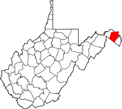
Scrabble
Location within the state of West Virginia
Usa edcp location map.svg
Red pog.svg
Scrabble
Scrabble (the United States)
Coordinates: 39°29′1″N77°49′57″W / 39.48361°N 77.83250°W / 39.48361; -77.83250
Country United States
State West Virginia
County Berkeley
Elevation
[1]
367 ft (112 m)
Time zone UTC-5 (Eastern (EST))
  Summer (DST) UTC-4 (EDT)
GNIS feature ID1549918 [1]

Scrabble is an unincorporated community in Berkeley County, West Virginia, United States. According to the Geographic Names Information System, the community has been known as Hard Scrabble, Hard Scrabble Town, and Hardscrabble throughout its history.

The community most likely was so named on account of treacherous local terrain. [2]

Scrabble Historic District

Scrabble Historic District
LocationScrabble Rd. and Dam No. 4 Rd., Scrabble, West Virginia
Area62 acres (25 ha)
Architectural styleGreek Revival
NRHP reference No. 06000171 [3]
Added to NRHPMarch 22, 2006

Scrabble was listed on the National Register of Historic Places in 2006, with the district extending into Jefferson County. [3] The historic district comprises 62 acres (25 ha) of late 19th century buildings mixed with agricultural lands. The most prominent structures are the 1920 Mount Wesley Methodist Episcopal Church and the 1882 Scrabble School. A number of contemporary I-houses and smaller vernacular houses complete the district. The individually listed George Washington Hollida House is also in the district. The district lies primarily on Scrabble Road and Dam No. 4 Road in Berkeley County, and Silver Spring Road in Jefferson County. The county line is marked by Rocky Marsh Run, which runs through the community. [4]

Related Research Articles

North River Mills is a historic unincorporated community in Hampshire County in the U.S. state of West Virginia. North River Mills is located between Capon Bridge and Slanesville on Cold Stream Road at its intersection with North River Road. The village of North River Mills lies along the eastern banks of North River from which it takes its name.

<span class="mw-page-title-main">Darkesville, West Virginia</span> Historic house in West Virginia, United States

Darkesville is an unincorporated community in Berkeley County, West Virginia, United States. Established in 1791, Darkesville has been nationally recognized as a historic district.

Files Crossroad is an unincorporated community in Berkeley County, West Virginia, United States. The community is located east of Martinsburg on West Virginia Route 45 at its crossroads with County Route 45/4. The community was originally known as Smoketown, hence the name of its historic Smoketown Cemetery.

Jones Springs is an unincorporated community in Berkeley County, West Virginia, United States. It is located on County Route 7 at its junction with County Route 7/8. The town, and several of its houses, are adjacent to the numerous springs that give the community its name.

Marlowe is an unincorporated community on U.S. Route 11 in Berkeley County, West Virginia, United States.

Nollville is an unincorporated community on Tuscarora Creek in Berkeley County, West Virginia, United States. It lies west of Martinsburg on the Tuscarora Pike.

Ridgeway is an unincorporated community in Berkeley County, West Virginia, United States. It lies off U.S. Route 11 on Specks Run Road near the Virginia state line.

<span class="mw-page-title-main">Tomahawk, West Virginia</span> Unincorporated community in West Virginia, United States

Tomahawk is an unincorporated community on Back Creek in Berkeley County, West Virginia, United States. The community is named for a nearby series of springs in the shape of a tomahawk. The community includes the historic Tomahawk Presbyterian Church, established c. 1745, and its adjacent community cemetery, which has gravestones dating to the late 18th century. Tomahawk also has a popular dirt bike racetrack. The community lies 9.5 miles from Martinsburg.

<span class="mw-page-title-main">Jefferson Rock</span>

Jefferson Rock is a rock formation on the Appalachian Trail in Harpers Ferry, West Virginia. It consists of several large masses of Harpers shale, piled one upon the other, that overlook the Shenandoah River just prior to its confluence with the Potomac River. It was added to the National Register of Historic Places as a contributing property of the Harpers Ferry National Historical Park on October 15, 1966.

<span class="mw-page-title-main">Burke's Garden, Virginia</span> Unincorporated community in Virginia, United States

Burke's Garden is an upland valley and unincorporated community in Tazewell County, Virginia.

<span class="mw-page-title-main">Todd, North Carolina</span> Unincorporated community in North Carolina, United States

Todd is an unincorporated community straddling the county lines of Watauga and Ashe counties in northwestern North Carolina, United States on the South Fork of the New River. It lies at an elevation of 2,992 feet. The population was 2,141 at the 2010 United States Census. The ZIP Code for Todd is 28684.

<span class="mw-page-title-main">National Register of Historic Places listings in Berkeley County, West Virginia</span>

This is a list of the National Register of Historic Places listings in Berkeley County, West Virginia.

<span class="mw-page-title-main">National Register of Historic Places listings in Jefferson County, West Virginia</span>

This is a list of the National Register of Historic Places listings in Jefferson County, West Virginia.

<span class="mw-page-title-main">Bunker Hill Historic District</span> Historic church in West Virginia, United States

The Bunker Hill Historic District is the center of the town of Bunker Hill, West Virginia. Today located on the road called US 11, the town was developed along the Martinsburg, West Virginia - Winchester, Virginia road. Bunker Hill served southern Berkeley County with three stores, six mills, and five churches. It was also home to a significant African-American population.

<span class="mw-page-title-main">Arneytown, New Jersey</span> Populated place in Burlington County, New Jersey, US

Arneytown is an unincorporated community located along Province Line Road on the border of North Hanover Township in Burlington County and Upper Freehold Township in Monmouth County of New Jersey. It is two miles (3.2 km) north of Jacobstown. Province Line Road was on the boundary line between the Provinces of East Jersey and West Jersey. The area was once called Upper Freehold by 18th-century Quaker settlers. With the establishment of the first post office in 1827, it became known as Arneytown.

<span class="mw-page-title-main">Headquarters, New Jersey</span> Populated place in Hunterdon County, New Jersey, US

Headquarters is an unincorporated community located within the Amwell Valley of Delaware Township in Hunterdon County, New Jersey. The settlement is centered around the intersection of Zentek Road and County Route 604. It is about 3 miles (4.8 km) from Ringoes to the east and 1 mile (1.6 km) from Sergeantsville to the west. The Headquarters Historic District was listed on the state and national registers of historic places in 2011 and had its boundary increased in 2016.

<span class="mw-page-title-main">Morgan Morgan Monument</span> United States historic place

The Morgan Morgan Monument, also known as Morgan Park, is a 1.05-acre (0.4 ha) roadside park in the unincorporated town of Bunker Hill in Berkeley County, West Virginia. It is located along Winchester Avenue and Mill Creek. The park features a granite monument that was erected in 1924 to memorialize Morgan Morgan (1688–1766), an American pioneer of Welsh descent, who was among the earliest European persons to settle permanently within the present-day boundaries of West Virginia.

<span class="mw-page-title-main">Middle Valley, New Jersey</span> Populated place in Morris County, New Jersey, US

Middle Valley is an unincorporated community located along Middle Valley Road and County Route 513 in Washington Township, Morris County, New Jersey. It is located near Long Valley within the valley of the South Branch Raritan River. The Middle Valley Historic District was listed on the state and national registers of historic places in 1989 and 1990.

The Rocks, also known as Raven's Rock and Raven Rocks, is a late-18th-century stone residence and 79-acre (32 ha) farm complex near Charles Town, Jefferson County, in the U.S. state of West Virginia. The Rocks is a historic district consisting of four contributing structures. The primary structure is a 2-and-a-half-story stone residence known as The Rocks, which was built around 1790, in the Georgian architectural style.

References

  1. 1 2 U.S. Geological Survey Geographic Names Information System: Scrabble, West Virginia
  2. Kenny, Hamill (1945). West Virginia Place Names: Their Origin and Meaning, Including the Nomenclature of the Streams and Mountains. Piedmont, WV: The Place Name Press. p. 560.
  3. 1 2 "National Register Information System". National Register of Historic Places . National Park Service. March 13, 2009.
  4. Taylor, David (July 2005). "Scrabble Historic District" (PDF). National Park Service. Retrieved April 4, 2011.