North River Mills is a historic unincorporated community in Hampshire County in the U.S. state of West Virginia. North River Mills is located between Capon Bridge and Slanesville on Cold Stream Road at its intersection with North River Road. The village of North River Mills lies along the eastern banks of North River from which it takes its name.
Warm Springs is a census-designated place (CDP) in and the county seat of Bath County, Virginia, United States. The population as of the 2010 census was 123. It lies along U.S. Route 220 near the center of the county. Warm Springs includes the historical mill town called Germantown. To the west lies West Warm Springs.
Back Creek is a 59.5-mile-long (95.8 km) tributary of the Potomac River that flows north from Frederick County, Virginia, to Berkeley County in West Virginia's Eastern Panhandle. Back Creek originates along Frederick County's border with Hampshire County, West Virginia, at Farmer's Gap in the Great North Mountain. Its name reflects its location to the west of North Mountain. The perspective of colonists from the east in the 18th century led them to call it "Back Creek", because it lay to the back of North Mountain.

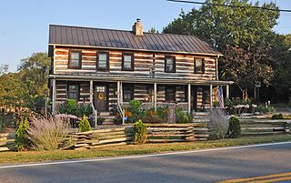
Capon Chapel, also historically known as Capon Baptist Chapel and Capon Chapel Church, is a mid-19th century United Methodist church located near to the town of Capon Bridge, West Virginia, in the United States. Capon Chapel is one of the oldest existing log churches in Hampshire County, along with Mount Bethel Church and Old Pine Church.
Darkesville is an unincorporated community in Berkeley County, West Virginia, United States. Established in 1791, Darkesville has been nationally recognized as a historic district.
Files Crossroad is an unincorporated community in Berkeley County, West Virginia, United States. The community is located east of Martinsburg on West Virginia Route 45 at its crossroads with County Route 45/4. The community was originally known as Smoketown, hence the name of its historic Smoketown Cemetery.
Ridgeway is an unincorporated community in Berkeley County, West Virginia, United States. It lies off U.S. Route 11 on Specks Run Road near the Virginia state line.
Owens is a small unincorporated crossroads community at the intersection of Dahlgren Road, Windsor Drive, and Owens Drive in King George County, Virginia, United States. State Routes 206 and 218 meet at this intersection, with 206 going east towards U.S. Route 301 and Dahlgren, 218 going south towards US 301 and Colonial Beach and 206 and 218 joined together going west towards Arnolds Corner and Fredericksburg. The eastern part of the community is within the Dahlgren census-designated place.
Lowell is an unincorporated community in Summers County, West Virginia, United States. Lowell is located on the Greenbrier River, east of Hinton and southwest of Alderson. The community was first settled in 1770 and is the oldest community in Summers County.

Salt Sulphur Springs is an unincorporated community in Monroe County, West Virginia, United States. Salt Sulphur Springs is located on U.S. Route 219, southwest of Union.
Frankford is an unincorporated community in Greenbrier County, West Virginia, United States. Frankford is located on U.S. Route 219, south of Falling Spring and north of Maxwelton. Frankford has a post office with ZIP code 24938.

Landisburg is an unincorporated community in Fayette County, West Virginia, United States. Landisburg is located along West Virginia Route 41, 11 miles (18 km) east of Oak Hill.
Bells Crossroad is an unincorporated community in Spotsylvania County, in the U.S. state of Virginia. This community is centered on the intersection of Stubbs Bridge Road and Lawyer's Road.
Belmont is an unincorporated community in Spotsylvania County, in the U.S. state of Virginia. It is marked with a highway sign at the intersection of Belmont Road and Orange Springs Road by the Virginia Department of Transportation, however is marked as being the intersection with Belmont Road and Jones Powell Road by the United States Geological Survey (USGS). The immediate area has Fletcher's Store and the Belmont Christmas Tree farm. Further south, there are other buildings identifying with Belmont, such as Belmont Baptist Church, the Belmont Ruritan Community Building where the Belmont Ruritan Club meets each evening at 7 p.m. and serves as the district's polling place for registered voters, and the Belmont Fire & Rescue station staffed by Spotsylvania County Volunteer Company 9.
Paytes is an unincorporated community in Spotsylvania County, in the U.S. state of Virginia. The community is marked at the intersection of Lawyer's Road and Catharpin Road by an electrical substation owned by Rappahannock Electric Co-op. A telecommunications tower was approved to be built on the site to expand cell coverage in the area on February 28, 2001.

Spring Grove is an unincorporated community in Surry County, Virginia, United States. Spring Grove is located at the junction of Virginia State Route 10 and Virginia State Route 40, 7.9 miles (12.7 km) west-northwest of Surry. Spring Grove has a post office with ZIP code 23881.
Cranesville is an unincorporated community in Preston County, West Virginia, United States. Cranesville is located along County Route 47, 7.9 miles (12.7 km) north-northeast of Terra Alta.

Little York is an unincorporated community located along the border of Alexandria and Holland townships in Hunterdon County, in the U.S. state of New Jersey. Little York is located on County Route 614 3.1 miles (5.0 km) north-northeast of Milford. Little York has a post office with ZIP Code 08834.

Alleghany Springs is an unincorporated community in Montgomery County, Virginia, United States. Alleghany Springs is located along State Route 637 7.9 miles (12.7 km) east of Christiansburg.

The Capon Lake Whipple Truss Bridge, formerly known as South Branch Bridge or Romney Bridge, is a historic Whipple truss bridge in Capon Lake, West Virginia. It is located off Carpers Pike and crosses the Cacapon River. The bridge formerly carried Capon Springs Road over the river, connecting Capon Springs and Capon Lake.


