Shanghai, West Virginia

Last updated

Shanghai
Shanghai WV.jpg
Shanghai, WV at the main intersection
USA West Virginia location map.svg
Red pog.svg
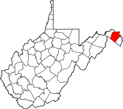
Shanghai
Location within the state of West Virginia
Usa edcp location map.svg
Red pog.svg
Shanghai
Shanghai (the United States)
Coordinates: 39°26′29″N78°07′56″W / 39.44139°N 78.13222°W / 39.44139; -78.13222
Country United States
State West Virginia
County Berkeley
Area
  Total204 sq mi (528 km2)
Elevation
[1]
528 ft (161 m)
Time zone UTC-5 (Eastern (EST))
  Summer (DST) UTC-4 (EDT)
GNIS feature ID1546614 [1]

Shanghai is an unincorporated community in Berkeley County, West Virginia, United States. The town is nestled in Back Creek Valley between Leading Ridge and North Mountain. Shanghai lies at the junction of West Virginia Secondary Route 7 (Back Creek Valley Road) and Secondary Route 18 [2] (Tuscarora Pike).

The community was named after a local lumber company, the Shanghai Manufacturing Association. [3] The Baldwin-Grantham House in Shanghai is a historic home listed on the National Register of Historic Places.

Related Research Articles

<span class="mw-page-title-main">Highland County, Virginia</span> County in Virginia, United States

Highland County is a county located in the Commonwealth of Virginia. As of the 2020 census, the population was 2,232, making it the state's least populous county. Its county seat is Monterey. Known as "Virginia's Switzerland" or "Virginia's Little Switzerland", Highland County is the least populous jurisdiction in Virginia, including counties and independent cities. Highland lays claim to being one of the least populous counties and one of the highest average elevations east of the Mississippi River.

<span class="mw-page-title-main">U.S. Route 91</span> Numbered Highway in Utah and Idaho in the United States

U.S. Route 91 or U.S. Highway 91 is a 172.7-mile-long (277.9 km) north–south United States highway running from Brigham City, Utah, to Idaho Falls, Idaho, in the U.S. states of Idaho and Utah. Despite the "1" as the last digit in the number, US 91 is no longer a cross-country artery, as it has mostly been replaced by Interstate 15. The highway currently serves to connect the communities of the Cache Valley to I-15 and beyond. Prior to the mid-1970s, US 91 was an international commerce route from Long Beach, California, to the Canada–US border north of Sweetgrass, Montana. US 91 was routed on the main streets of most of the communities it served, including Las Vegas Boulevard in Las Vegas and State Street in Salt Lake City. From Los Angeles to Salt Lake, the route was built along the corridor of the Arrowhead Trail. A portion of the highway's former route in California is currently State Route 91.

<span class="mw-page-title-main">U.S. Route 522</span> Highway in the United States

U.S. Route 522 is a spur route of US 22 in the states of Virginia, West Virginia, Maryland, and Pennsylvania. The U.S. Highway travels in a north-south direction, and runs 308.59 miles (496.63 km) from US 60 near Powhatan, Virginia, to its northern terminus at US 11 and US 15 near Selinsgrove, Pennsylvania. US 522 serves many small cities and towns in the Piedmont, Blue Ridge Mountains, and northern Shenandoah Valley of Virginia. The highway serves the Virginia communities of Goochland, Mineral, Culpeper, the town of Washington, and Front Royal and the independent city of Winchester. US 522 then follows the Ridge-and-Valley Appalachians north and then east through the Eastern Panhandle of West Virginia, a 2-mile-wide (3.2 km) stretch of Western Maryland, and South Central Pennsylvania to its terminus in the Susquehanna Valley. The highway serves Berkeley Springs, West Virginia; Hancock, Maryland; and the Pennsylvania communities of McConnellsburg, Mount Union, Lewistown, and Middleburg.

<span class="mw-page-title-main">West Virginia Route 45</span> State highway in West Virginia, United States

West Virginia Route 45 is a state highway in the U.S. state of West Virginia. The state highway runs 25.8 miles (41.5 km) from the Virginia state line near Glengary east to WV 230 and WV 480 in Shepherdstown. WV 45 connects the communities of Glengary and Arden in southwestern Berkeley County with the county seat of Martinsburg. The state highway also connects Shepherdstown in northern Jefferson County with Martinsburg, where the highway meets Interstate 81 (I-81), U.S. Route 11, and WV 9.

Back Creek is a 59.5-mile-long (95.8 km) tributary of the Potomac River that flows north from Frederick County, Virginia, to Berkeley County in West Virginia's Eastern Panhandle. Back Creek originates along Frederick County's border with Hampshire County, West Virginia, at Farmer's Gap in the Great North Mountain. Its name reflects its location to the west of North Mountain. The perspective of colonists from the east in the 18th century led them to call it "Back Creek", because it lay to the back of North Mountain.

<span class="mw-page-title-main">U.S. Route 50 in West Virginia</span> Segment of American highway

U.S. Route 50 in West Virginia runs from the border with Ohio to Virginia, passing briefly through Garrett County, Maryland, and following the Northwestern Turnpike. Prior to the U.S. Highway System it was West Virginia Route 1 and in the 1930s, the road was not finished in Maryland. Today the section of US 50 from Clarksburg to Parkersburg on the Ohio River is part of Corridor D of the Appalachian Development Highway System.

<span class="mw-page-title-main">Route 311 (Virginia–West Virginia)</span> Adjoining state highways in Virginia and West Virginia, US

Virginia State Route 311 and West Virginia Route 311 are adjoining state highways in the U.S. states of Virginia and West Virginia. The two state highways together run 58.7 miles (94.5 km) from U.S. Route 11 in Salem, Virginia north to Interstate 64 and U.S. Route 60 near White Sulphur Springs, West Virginia. The two Virginia portions of Route 311 are maintained by the Virginia Department of Transportation, with the exception of the city-maintained portion within Salem. The West Virginia segments are maintained by the West Virginia Division of Highways.

<span class="mw-page-title-main">Virginia State Route 16</span> State highway in western Virginia, US

State Route 16 is a primary state highway in the southwest part of the U.S. state of Virginia. It runs from the North Carolina border at North Carolina Highway 16 north to the West Virginia border at West Virginia Route 16, passing through the towns of Troutdale, Marion, and Tazewell. Highway 16 is part of a three-state route 16 that connects the Charlotte region with northwestern West Virginia.

<span class="mw-page-title-main">Virginia State Route 42</span> State highway in Virginia, US

State Route 42 is a primary state highway in the U.S. state of Virginia. Running parallel to and west of Interstate 81, SR 42 consists of three sections, with gaps filled by secondary routes in between. Some of SR 42 lies along the old Fincastle Turnpike. Another major piece, from near Clifton Forge to Buffalo Gap, parallels the old Virginia Central Railroad.

<span class="mw-page-title-main">Virginia State Route 91</span> State highway in western Virginia, US

State Route 91 is a primary state highway in the U.S. state of Virginia. The state highway runs 55.12 miles (88.71 km) from the Tennessee state line near Damascus, where the highway continues as Tennessee State Route 91, north to U.S. Route 19 Business and US 460 Business at Frog Level. SR 91 connects Damascus in southeastern Washington County with the northeastern county town Glade Spring, where the highway has junctions with US 11 and Interstate 81 (I-81). The state highway also indirectly connects Saltville in northwestern Smyth County and Tazewell, the county seat of Tazewell County. SR 91 is the only primary state highway in Virginia with an unpaved section; this gravel section is in southern Tazewell County.

<span class="mw-page-title-main">U.S. Route 19 in Virginia</span> State highway in Virginia

U.S. Route 19 (US 19) is a part of the United States Numbered Highway System that runs from Memphis, Florida, to Erie, Pennsylvania. In Virginia, the highway runs 88.89 miles (143.05 km) between two pairs of twin cities: Bristol, Tennessee, and Bristol, Virginia, at the Virginia–Tennessee state line, and Bluefield, Virginia, and Bluefield, West Virginia, at the Virginia–West Virginia state line. Between its endpoints, US 19 has lengthy concurrencies with US 11, US 58 Alternate, and US 460 during its course connecting Abingdon, Lebanon, and Tazewell within Washington, Russell, and Tazewell counties in Southwest Virginia.

<span class="mw-page-title-main">Virginia State Route 61</span> State highway in western Virginia, US

State Route 61 is a primary state highway in the U.S. state of Virginia. The state highway runs 48.16 miles (77.51 km) from SR 16 in Tazewell east to U.S. Route 460 in Narrows. SR 61 passes through several narrow creek valleys as it parallels the West Virginia state line through Tazewell, Bland, and Giles counties. The only sizeable community between the highway's endpoints is Rocky Gap, where the highway meets US 52 and Interstate 77 (I-77).

<span class="mw-page-title-main">Virginia State Route 84</span> State highway in Highland County, Virginia, US

State Route 84 is a primary state highway in the U.S. state of Virginia. Known as Mill Gap Road, the state highway runs 14.94 miles (24.04 km) from the West Virginia state line near Mill Gap, where the highway continues west as West Virginia Route 84, east to U.S. Route 220 at Vanderpool.

<span class="mw-page-title-main">U.S. Route 22 in Pennsylvania</span> Highway in Pennsylvania

U.S. Route 22 (US 22) is an east–west United States Numbered Highway that stretches from Cincinnati, Ohio, in the west, to Newark, New Jersey, in the east. In Pennsylvania, the route runs for 338.20 miles (544.28 km) between the West Virginia state line in Washington County, where it is a freeway through the western suburbs of Pittsburgh, and then runs east to Easton and the Pennsylvania–New Jersey state line in the Lehigh Valley region of eastern Pennsylvania.

<span class="mw-page-title-main">Virginia State Route 18</span> State highway in Virginia, United States

State Route 18 is a primary state highway in the U.S. state of Virginia. Known for most of its length as Potts Creek Road, the state highway runs 25.86 miles (41.62 km) from SR 311 in Paint Bank north to U.S. Route 60 and US 220 in Covington.

<span class="mw-page-title-main">Virginia State Route 39</span> State highway in Virginia, United States

State Route 39 is a primary state highway in the U.S. state of Virginia. The state highway runs 59.17 miles (95.22 km) from the West Virginia state line near Mountain Grove, where the highway continues as West Virginia Route 39, east to U.S. Route 11 in East Lexington. SR 39 connects Lexington with several communities formed around hot springs in Bath County. In Rockbridge County, the state highway passes through the town of Goshen and Goshen Pass, a gorge formed by the Maury River.

<span class="mw-page-title-main">Interstate 78 in Pennsylvania</span> Highway in Pennsylvania, US

Interstate 78 (I-78) is a major east–west Interstate Highway stretching from Union Township, Lebanon County, Pennsylvania, in the west to the Holland Tunnel and New York City in the east. In Pennsylvania, I-78 runs for about 78 miles (126 km) from the western terminus at I-81 in Union Township east to the New Jersey state line near Easton in Northampton County.

<span class="mw-page-title-main">U.S. Route 250 in Virginia</span> Segment of American highway

U.S. Route 250 is a part of the U.S. Highway System that runs from Sandusky, Ohio to Richmond, Virginia. In Virginia, the highway runs 166.74 miles (268.34 km) from the West Virginia state line near Hightown east to its eastern terminus at US 360 in Richmond. US 250 is the main east–west highway of Highland County, which is known as Virginia's Little Switzerland; the highway follows the path of the 19th century Staunton and Parkersburg Turnpike. From Staunton east to Richmond, the highway serves as the local complement to Interstate 64 (I-64), roughly following the 18th century Three Notch'd Road through Waynesboro and Charlottesville on its way through the Shenandoah Valley, its crossing of the Blue Ridge Mountains at Rockfish Gap, and the Piedmont. In the Richmond metropolitan area, US 250 is known as Broad Street, a major thoroughfare through the city's West End and downtown areas.

Buffalo Creek is a 4.1-mile-long (6.6 km) free-flowing tributary stream of the South Branch Potomac River, itself a tributary of the Potomac River, making it a part of the Chesapeake Bay watershed. Buffalo Creek is located in west-central Hampshire County in the U.S. state of West Virginia. Because the stream flows through several small farms, Buffalo Creek primarily serves agriculture purposes with segments used for livestock watering.

References

  1. 1 2 U.S. Geological Survey Geographic Names Information System: Shanghai, West Virginia
  2. Google Maps https://maps.google.com/maps?hl=en&q=39.3401407+N,+78.0624290+W&bav=on.2,or.r_gc.r_pw.&um=1&ie=UTF-8&hq=&hnear=%2B39%C2%B0+20%27+25.42%22,+-78%C2%B0+3%27+44.52%22&gl=us&ei=f3WYTbfcLumN0QGavZT1Cw&sa=X&oi=geocode_result&ct=image&resnum=1&ved=0CBUQ8gEwAA Google Maps.{{cite web}}: Check |url= value (help); Missing or empty |title= (help)
  3. Kenny, Hamill (1945). West Virginia Place Names: Their Origin and Meaning, Including the Nomenclature of the Streams and Mountains. Piedmont, WV: The Place Name Press. p. 567.