Van Clevesville, West Virginia

Last updated

Van Clevesville
USA West Virginia location map.svg
Red pog.svg
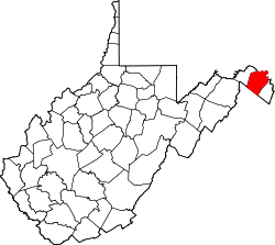
Van Clevesville
Location within the state of West Virginia
Usa edcp location map.svg
Red pog.svg
Van Clevesville
Van Clevesville (the United States)
Coordinates: 39°25′44″N77°54′18″W / 39.42889°N 77.90500°W / 39.42889; -77.90500
Country United States
State West Virginia
County Berkeley
Elevation
[1]
472 ft (144 m)
Time zone UTC-5 (Eastern (EST))
  Summer (DST) UTC-4 (EDT)
GNIS feature ID1555876 [1]

Van Clevesville is an unincorporated community in Berkeley County, West Virginia, United States. It is located between the communities of Baker Heights and Winebrenners Crossroad.

Related Research Articles

<span class="mw-page-title-main">West Virginia</span> U.S. state

West Virginia is a state in the Southern and Mid-Atlantic regions of the United States. It is bordered by Pennsylvania to the north and east, Maryland to the east and northeast, Virginia to the southeast, Kentucky to the southwest, and Ohio to the northwest. West Virginia is the 10th-smallest state by area and ranks as the 12th-least populous state, with a population of 1,793,716 residents. The capital and most populous city is Charleston with a population of 49,055.

<span class="mw-page-title-main">Van, West Virginia</span> Census-designated place in West Virginia, United States

Van is a census-designated place (CDP) in Boone County, West Virginia, United States, along the Pond Fork of the Little Coal River. As of the 2010 census, its population was 211. Its ZIP code is 25206. Van was named after Van Linville, who established its post office and served as its first postmaster.

<span class="mw-page-title-main">Boone County, West Virginia</span> County in West Virginia, United States

Boone County is a county in the U.S. state of West Virginia. As of the 2020 census, the population was 21,809. Its county seat is Madison. Boone County is part of the Charleston, WV Metropolitan Statistical Area. Leading industries and chief agricultural products in Boone County include coal, lumber, natural gas, tobacco, and strawberries.

<span class="mw-page-title-main">Berkeley County, West Virginia</span> County in West Virginia, United States

Berkeley County is located in the Shenandoah Valley in the eastern panhandle region of West Virginia in the United States. The county is part of the Hagerstown–Martinsburg metropolitan area. As of the 2020 census, the county population was 122,076, making it the second-most populous of West Virginia's 55 counties, behind Kanawha County. The City of Martinsburg is the county seat.

<span class="mw-page-title-main">Arthur I. Boreman</span> American lawyer, politician, and judge

Arthur Ingram Boreman was an American lawyer, politician and judge who helped found the U.S. state of West Virginia. Raised in Tyler County, West Virginia, he served as the state's first Governor, and a United States senator, as well as represented Wood County in the Virginia House of Delegates, and served as a circuit judge before and after his federal service.

<span class="mw-page-title-main">Chesapeake and Ohio Railway</span> Defunct American Class I railway

The Chesapeake and Ohio Railway was a Class I railroad formed in 1869 in Virginia from several smaller Virginia railroads begun in the 19th century. Led by industrialist Collis P. Huntington, it reached from Virginia's capital city of Richmond to the Ohio River by 1873, where the railroad town of Huntington, West Virginia, was named for him.

<span class="mw-page-title-main">Middle Island Creek</span> River in West Virginia, United States

Middle Island Creek is a river, 77 miles (124 km) long, in northwestern West Virginia in the United States. It is a tributary of the Ohio River, draining an area of 565 square miles (1,463 km2) on the unglaciated Allegheny Plateau. It was named by late 18th century pioneering travelers on the Ohio River, who noted the location of the Creek's mouth opposite Middle Island in the larger river.

<span class="mw-page-title-main">Glebe, West Virginia</span> Unincorporated community in West Virginia, United States

Glebe was an unincorporated community in Hampshire County, West Virginia, United States. It is situated at the lower mouth of the Trough, a gorge of the South Branch Potomac River, and is about 9.5 miles (15.3 km) southwest of Romney on South Branch River Road. The community received its name from the old stone glebehouse (parsonage) that was constructed there in the late 18th century. The stone house later became the Hampshire County Poor Farm and remains standing. The community of Sector lies directly across the river.

Winebrenners Crossroad is a small unincorporated community along the Warm Springs Road southeast of Martinsburg in Berkeley County, West Virginia, United States. It is centered on the intersection or "crossroad" of the Warm Springs Road with Van Clevesville Road and Winebrenner Road. The Crossroad area is the site of the 18th century Strayer-Couchman House listed on the National Register of Historic Places.

<span class="mw-page-title-main">Old Fields, West Virginia</span> Unincorporated community in West Virginia, United States

Old Fields is an unincorporated community on the South Branch Potomac River in northern Hardy County, West Virginia, United States.

<span class="mw-page-title-main">Bandytown, West Virginia</span> Unincorporated community in West Virginia, United States

Bandytown is an unincorporated community in Boone County, West Virginia, United States. Bandytown is approximately 18 miles from Madison. Bandytown is accessible from Boone County Route 26, which is located right off West Virginia Route 85 at the Van Bridge split. The community has a total population of over 100 with approximately 70 homes.

<span class="mw-page-title-main">Broadlands, Virginia</span> Census-designated place in Virginia

Broadlands is a census-designated place (CDP) in Loudoun County, Virginia, United States. It is a 1,500-acre (610 ha) master-planned community started and developed by Van Metre Homes in the 1990s. It is built on wetlands and is certified as a Community Wildlife Habitat by the National Wildlife Federation.

Lindytown is an unincorporated community in Boone County, West Virginia, United States. Lindytown was founded at the time Charles Lindbergh made his famous flight across the Atlantic and is based on a 50-acre (200,000 m2) tract of land. Lindytown is approximately 22 miles (35 km) from Madison. Lindytown is accessible from Boone County Route 26, which is located off West Virginia Route 85 at the Van Bridge split.

Gordon is an unincorporated community and coal town in Boone County, West Virginia, United States. Gordon is approximately 12 miles from Madison. Gordon is accessible from Boone County Route 26, which is located right off West Virginia Route 85 at the Van Bridge split.

Van Voorhis is an unincorporated community in Monongalia County, West Virginia, United States. Van Voorhis is located on the south bank of the Monongahela River across from West Van Voorhis, 3.5 miles (5.6 km) north of Morgantown.

West Van Voorhis is an unincorporated community in Monongalia County, West Virginia, United States. West Van Voorhis is located on the north bank of the Monongahela River across from Van Voorhis, 4 miles (6.4 km) north of Morgantown.

Sweetland is an unincorporated community in Lincoln County, West Virginia, United States. Sweetland is located on West Virginia Route 3 and the Middle Fork Mud River, 3.5 miles (5.6 km) east-southeast of Hamlin. Sweetland had a post office, which closed on December 14, 1996.

Van Camp is an unincorporated community in Wetzel County, West Virginia, United States.

<span class="mw-page-title-main">1863 West Virginia gubernatorial election</span>

The 1863 West Virginia gubernatorial election, held on May 28, resulted in the victory of Arthur I. Boreman. He received the nomination of the Unconditional Union Party and won with no opposition in the general election.

Upton Buhrman was an American politician from Maryland. He served as a member of the Maryland House of Delegates, representing Frederick County, from 1864 to 1867.

References