Tarico Heights, West Virginia

Last updated

Tarico Heights
USA West Virginia location map.svg
Red pog.svg
Tarico Heights
Location within the state of West Virginia
Usa edcp location map.svg
Red pog.svg
Tarico Heights
Tarico Heights (the United States)
Coordinates: 39°19′35″N78°00′14″W / 39.32639°N 78.00389°W / 39.32639; -78.00389
Country United States
State West Virginia
County Berkeley
Elevation
[1]
574 ft (175 m)
Time zone UTC-5 (Eastern (EST))
  Summer (DST) UTC-4 (EDT)
GNIS feature ID1547905 [1]

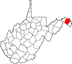
Tarico Heights is an unincorporated community on West Virginia Route 51 along Opequon Creek in Berkeley County, West Virginia, United States.

Related Research Articles

<span class="mw-page-title-main">Logan County, West Virginia</span> County in West Virginia, United States

Logan County is a county in the U.S. state of West Virginia. As of the 2020 census, the population was 32,567. Its county seat is Logan. Logan County comprises the Logan, WV Micropolitan Statistical Area, which is also included in the Charleston–Huntington–Ashland, WV–OH–KY Combined Statistical Area.

<span class="mw-page-title-main">Berkeley County, West Virginia</span> County in West Virginia, United States

Berkeley County is located in the Shenandoah Valley in the eastern panhandle region of West Virginia in the United States. The county is part of the Hagerstown–Martinsburg metropolitan area. As of the 2020 census, the county population was 122,076, making it the second-most populous of West Virginia's 55 counties, behind Kanawha County. The City of Martinsburg is the county seat.

<span class="mw-page-title-main">Colonial Heights, Virginia</span> Independent city in Virginia, United States

Colonial Heights is an independent city in the Commonwealth of Virginia. As of the 2020 census, the population was 18,170. The Bureau of Economic Analysis combines the City of Colonial Heights with Dinwiddie County for statistical purposes.

<span class="mw-page-title-main">Mitchell Heights, West Virginia</span> Town in West Virginia, United States

Mitchell Heights is a town in Logan County, West Virginia, United States. The population was 315 at the 2020 census. The town was named for an early farm on which it was established.
<span class="mw-page-title-main">Battle of Harpers Ferry</span> Battle of the American Civil War

The Battle of Harpers Ferry was fought September 12–15, 1862, as part of the Maryland Campaign of the American Civil War. As Confederate Army General Robert E. Lee's Confederate army invaded Maryland, a portion of his army under Major General Thomas J. "Stonewall" Jackson surrounded, bombarded, and captured the Union garrison at Harpers Ferry, Virginia.

<span class="mw-page-title-main">West Virginia Route 51</span> State highway in West Virginia, United States

West Virginia Route 51 is a state highway that runs west to east from Berkeley County to Jefferson County in West Virginia's Eastern Panhandle. The western terminus is at WV 45 northwest of Gerrardstown. The eastern terminus is at an interchange with U.S. Route 340 and WV 9 east of downtown Charles Town. US 340 continues to the east on the same roadway as WV 51.

<span class="mw-page-title-main">Opequon Creek</span>

Opequon Creek is an approximately 35 mile tributary stream of the Potomac River. It flows into the Potomac northeast of Martinsburg in Berkeley County, West Virginia, and its source lies northwest of the community of Opequon at the foot of Great North Mountain in Frederick County, Virginia. The Opequon forms part of the boundary between Frederick and Clarke counties in Virginia and also partially forms the boundary between Berkeley and Jefferson counties in West Virginia's Eastern Panhandle.

Baker Heights is an unincorporated community near Opequon Creek in Berkeley County in the U.S. state of West Virginia. Located on West Virginia Route 9 southeast of Martinsburg, Baker Heights is the site of the Martinsburg Veterans Affairs Medical Center.

Mechlenberg Heights is an unincorporated community in Jefferson County, West Virginia, United States. Mechlenberg Heights lies to the west of Shepherdstown along West Virginia Route 45.

<span class="mw-page-title-main">Weirton–Steubenville metropolitan area</span> Metropolitan Statistical Area in the United States

The Weirton–Steubenville, WV–OH Metropolitan Statistical Area, also known as the Upper Ohio Valley, is a metropolitan statistical area consisting of two counties in the Northern Panhandle of West Virginia and one in Ohio, anchored by the cities of Weirton and Steubenville. As of the 2020 census, the MSA had a population of 116,903. This puts it at 334th largest in the United States. It is also included in the larger Pittsburgh–New Castle–Weirton, PA–OH–WV Combined Statistical Area.

Valley Heights is an unincorporated community in Summers County, West Virginia, United States. The community is located along the Greenbrier River, approximately 7 miles (11 km) southwest of Alderson and 15 miles (24 km) east of Hinton. Valley Heights is served by West Virginia Route 3 and West Virginia Route 12.

Charlton Heights is a census-designated place (CDP) in Fayette County, West Virginia, United States. Charlton Heights is located on the north bank of the Kanawha River, 4 miles (6.4 km) southwest of Gauley Bridge. Charlton Heights has a post office with ZIP code 25040. As of the 2010 census, its population was 406.

Montgomery Heights is an unincorporated community in Fayette County, West Virginia, United States. Montgomery Heights is located on the south bank of the Kanawha River, 4.5 miles (7.2 km) southeast of Montgomery.

Beard Heights is an unincorporated community in Pocahontas County, West Virginia, United States. Beard Heights is located on U.S. Route 219, 1.5 miles (2.4 km) southwest of Marlinton.

Tyler Heights, also known as Flatwoods, is an unincorporated community in Kanawha County, West Virginia, United States. Tyler Heights is located along West Virginia Route 622 at its junction with West Virginia Route 501, 5 miles (8.0 km) east-northeast of Nitro.

<span class="mw-page-title-main">Godby Heights, West Virginia</span> Unincorporated community in West Virginia, United States

Godby Heights is an unincorporated community in Logan County, West Virginia, United States.

Logan Heights is an unincorporated community in Logan County, West Virginia, United States. It is part of the Mount Gay-Shamrock census-designated place.

Morgan Heights is an unincorporated community in Monongalia County, West Virginia, United States.

References