
Pilot Mountain State Park is a North Carolina state park in Surry and Yadkin Counties, North Carolina in the United States. Located near Pinnacle, North Carolina on highway US 52, it covers 3,872 acres (15.67 km2) and includes the distinctive 2,241 foot (683 m) peak of Pilot Mountain.

Robbers Cave State Park is a state park in Latimer County, Oklahoma. It is located 5 miles (8.0 km) north of Wilburton, Oklahoma, on State Highway 2. Originally named Latimer State Park, it received its current name in 1936. It is located in the scenic, hilly woodlands of the Sans Bois Mountains of southeast Oklahoma. This park is a favorite of rappellers, equestrians, hikers and outdoor lovers. The park and adjoining wildlife management area covers more than 8,000 acres (3,200 ha) and includes three lakes. It offers visitors acres of discovery and enjoyment including trout fishing in season, boating, hunting, mountain biking, trails for hikers and horses, sandstone cliffs for climbing and rappelling, and fall foliage viewing. In addition, Robbers Cave is historically notable as a former hideout for infamous outlaws Belle Starr and Jesse James.
At 47,527 acres (192.33 km2), Harriman State Park is the second largest state park in the U.S. state of New York. Located in Rockland and Orange counties 30 miles (48 km) north of New York City, it is a haven for hikers with over 200 miles (320 km) of hiking trails. The park is also known for its 31 lakes, multiple streams, public camping area, and great vistas. The park's hiking trails are currently maintained by volunteers from the New York - New Jersey Trail Conference.
Cherry Plain State Park is a 175-acre (0.71 km2) state park located in Rensselaer County, New York in the United States. The park is located in Cherry Plain at the southwest part of the Town of Berlin, near the Massachusetts border. Outdoor recreational opportunities are also available within the Capital District Wildlife Management Area, a 4,153-acre (16.81 km2) conservation area that nearly surrounds the park.

Worlds End State Park is a 780-acre (316 ha) Pennsylvania state park in Sullivan County, Pennsylvania. The park, nearly surrounded by Loyalsock State Forest, is in the Loyalsock Creek valley on Pennsylvania Route 154 in Forks and Shrewsbury Townships southeast of the borough of Forksville. The name Worlds End has been used since at least 1872, but its origins are uncertain. Although it was founded as Worlds End State Forest Park by Governor Gifford Pinchot in 1932, the park was officially known as Whirls End State Forest Park from 1936 to 1943.

Wekiwa Springs State Park is a 7,000-acre (28 km2) Florida State Park in Apopka, Florida. It is located 20 minutes north of Orlando, off Interstate 4 at exit 94, near Altamonte Springs and Longwood. The park also contains the head water of the Wekiva River. It also serves as the headquarters of one of the state's five AmeriCorps Florida State Parks chapters.

J.W. Wells State Park is a state park in the U.S. state of Michigan. The 678-acre (2.74 km2) park is located in Menominee County on the shore of Lake Michigan's Green Bay, just south of Cedar River. It is on M-35, roughly midway between Menominee and Escanaba. It was added to the National Register of Historic Places in 2002.

Wilgus State Park is a state park in Ascutney, Vermont. The park offers canoeing along the Connecticut River and hiking up the Pinnacle Trail. The park has tent and lean-to sites and is quite close to Mount Ascutney and the Saint-Gaudens National Historic Site. The park was originally constructed by the Civilian Conservation Corps (CCC) and is now administered by the Vermont Department of Forests, Parks, and Recreation as part of the Vermont state park system. It is named after William J. Wilgus, who donated the land for the park in 1933. The park is listed on the National Register of Historic Places for its well-preserved CCC infrastructure.

Upper Pine Bottom State Park is a 5-acre (2.0 ha) Pennsylvania state park in Lycoming County, Pennsylvania in the United States. The park is in Cummings Township on Pennsylvania Route 44 and is surrounded by the Tiadaghton State Forest. It is on Upper Pine Bottom Run, which gave the park its name and is a tributary of Pine Creek. Upper Pine Bottom State Park is in the Pine Creek Gorge, where the streams have cut through five major rock formations from the Devonian and Carboniferous periods.
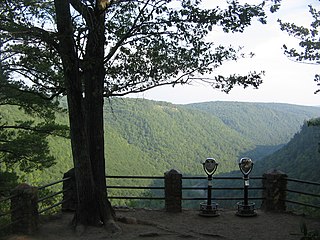
Colton Point State Park is a 368-acre (149 ha) Pennsylvania state park in Tioga County, Pennsylvania, in the United States. It is on the west side of the Pine Creek Gorge, also known as the Grand Canyon of Pennsylvania, which is 800 feet (240 m) deep and nearly 4,000 feet (1,200 m) across at this location. The park extends from the creek in the bottom of the gorge up to the rim and across part of the plateau to the west. Colton Point State Park is known for its views of the Pine Creek Gorge, and offers opportunities for picnicking, hiking, fishing and hunting, whitewater boating, and camping. Colton Point is surrounded by Tioga State Forest and its sister park, Leonard Harrison State Park, on the east rim. The park is on a state forest road in Shippen Township 5 miles (8 km) south of U.S. Route 6.

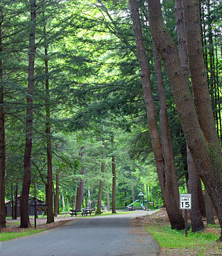
Black Moshannon State Park is a 3,480-acre (1,410 ha) Pennsylvania state park in Rush Township, Centre County, Pennsylvania, United States. It surrounds Black Moshannon Lake, formed by a dam on Black Moshannon Creek, which has given its name to the lake and park. The park is just west of the Allegheny Front, 9 miles (14 km) east of Philipsburg on Pennsylvania Route 504, and is largely surrounded by Moshannon State Forest. A bog in the park provides a habitat for diverse wildlife not common in other areas of the state, such as carnivorous plants, orchids, and species normally found farther north. As home to the "largest reconstituted bog in Pennsylvania", it was chosen by the Pennsylvania Department of Conservation and Natural Resources for its "25 Must-see Pennsylvania State Parks" list.

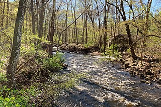
Ravensburg State Park is a Pennsylvania state park in Crawford Township in Clinton County, Pennsylvania in the United States. It is in a gorge carved by Rauchtown Run through the side of Nippenose Mountain. Ravensburg State Park is 78 acres (32 ha) of wooded land that is almost entirely surrounded by Tiadaghton State Forest. This state park is on Pennsylvania Route 880, 8 miles (13 km) north of Carroll and 8 miles (13 km) south-east of Jersey Shore. The nearest city is Williamsport.
Sizerville State Park is a 386-acre (156 ha) Pennsylvania state park in Portage Township, Cameron County and Portage Township, Potter County, Pennsylvania in the United States. The park is nearly surrounded by Elk State Forest making it part of one of the largest blocks of state-owned land in Pennsylvania. Sizerville State Park is on Pennsylvania Route 155, six miles (10 km) north of the borough of Emporium.

Promised Land State Park is a Pennsylvania state park in Blooming Grove, Greene and Palmyra Townships, Pike County, Pennsylvania, in the United States. The approximately 3,000-acre (1,214 ha) park is mostly surrounded by Delaware State Forest. It is in the Poconos and sits at an elevation of 1,800 feet (549 m). The second growth forests in Promised Land State Park are made up of beech, maple, oak and hemlock trees. There are two lakes within the boundaries of the park. Promised Land State Park is 10 miles (16 km) north of Canadensis on Pennsylvania Route 390.

Table Rock State Park is a 3,083-acre (12.48 km2) park at the edge of the Blue Ridge Mountains in northern Pickens County, South Carolina. The park includes Pinnacle Mountain, the tallest mountain totally within the state.

Backbone State Park is Iowa's oldest state park, dedicated in 1919. Located in the valley of the Maquoketa River, it is approximately three miles (5 km) south of Strawberry Point in Delaware County. It is named for a narrow and steep ridge of bedrock carved by a loop of the Maquoketa River originally known as the Devil's Backbone. The initial 1,200 acres (490 ha) were donated by E.M. Carr of Lamont, Iowa. Backbone Lake Dam, a relatively low dam built by the Civilian Conservation Corps (CCC) in the 1930s, created Backbone Lake. The CCC constructed a majority of trails and buildings which make up the park.
The Black River County Park is a public park in Morris County, New Jersey operated by the Morris County Park Commission.

Pattison State Park is a 1,436-acre (581 ha) Wisconsin state park south of Superior, Wisconsin. Situated on the Black River, the park contains both Big Manitou Falls, the highest waterfall in Wisconsin at 165 feet (50 m), and Little Manitou Falls, which is 30 feet (9.1 m). Pattison State Park was established in 1920.

Penn State Forest is a 3,366-acre (5.259 sq mi) state park in Burlington County, New Jersey, United States. The forest is protected as a section of the environmentally sensitive Pine Barrens. Various recreational resources are available to visitors including Oswego Lake and the Oswego River for boating and fishing. The lake has a picnic area with a boat launch and primitive restrooms. Miles of unpaved roads composed of gravel, dirt, and sand traverse all areas of the forest. The roads are open for hiking, mountain biking, horseback riding, and cross-country skiing, as well as four-wheel driving. Hunting for deer, wild turkey, water fowl, and small game is permitted in season. A section of the Pine Barren Plains, a globally rare dwarf forest ecosystem that reaches a mature canopy height of about 4 ft (1.2 m), is located in the northeastern portion of the park. Penn State Forest is operated and maintained by the New Jersey Division of Parks and Forestry.
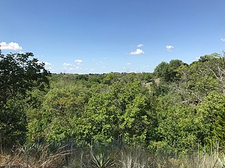
The Fort Worth Nature Center & Refuge is a nature center located between Lakeside and Lake Worth, Texas within Fort Worth, Texas, United States city limits. It consists of prairies, forests, and wetlands. The nature center offers a glimpse of what the Dallas–Fort Worth metroplex looked like before settlement. The center covers 3,621 acres (1,465 ha) and includes over 20 miles (32 km) of hiking trails. It is one of the largest city-owned nature centers in the United States.


