
Musconetcong Mountain is a ridge in the Highlands region of New Jersey running south of and parallel to the Musconetcong River. The ridge travels through Alexandria, Holland, Bethlehem and Lebanon Township. [1]
Musconetcong Mountain is a ridge in the Highlands region of New Jersey running south of and parallel to the Musconetcong River. The ridge travels through Alexandria, Holland, Bethlehem and Lebanon Township. [1]
The southern boundary of the Central Delaware Valley AVA, an American Viticultural Area, is near Titusville, New Jersey, and its northern border is near Musconetcong Mountain.

The Musconetcong River is a 45.7-mile-long (73.5 km) tributary of the Delaware River in northwestern New Jersey in the United States. It flows through the rural mountainous country of northwestern New Jersey. The name derives from the Lenape words moschakgeu meaning "clear" and hannek meaning "stream". Part of it is a National Wild and Scenic River.
Pohatcong Creek is a 30.7-mile-long (49.4 km) tributary of the Delaware River in northwestern New Jersey in the United States.

Schooley's or, officially, Schooleys Mountain is a mountain ridge in northern New Jersey that stretches from Lake Hopatcong in the north to Hampton in the south. It is centrally located within the southern Highlands, positioned almost equidistantly from the Kittatinny Valley in the west and the Piedmont plateau in the east. Schooley's Mountain is also one of the largest ridges in a group of geologically similar and parallel mountains, which include Allamuchy Mountain, Pohatcong Mountain, Scotts Mountain, and Jenny Jump Mountain.

The Skylands Region is a region of New Jersey located in the northern and central parts of the state. It is one of seven tourism regions established by the New Jersey State Department of Tourism; the others are Gateway Region, Greater Atlantic City Region, the Southern Shore Region, the Delaware River Region, the Shore Region, and the Central Jersey Region.
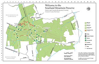
The Sourland Mountain Preserve is located on Sourland Mountain, in the Sourlands region of New Jersey. It is within Hillsborough Township and Montgomery Township of Somerset County. The largest donation of land was made by Norma Gilbert Farr, trustee of the Linus R. Gilbert Foundation. The Farr family has donated over 3,000 acres to the Sourland Mountain Preserve and the Somerset County Parks Commission.
The Appalachian National Scenic Trail spans 14 U.S. states over its roughly 2,200 miles (3,500 km): Georgia, North Carolina, Tennessee, Virginia, West Virginia, Maryland, Pennsylvania, New Jersey, New York, Connecticut, Massachusetts, Vermont, New Hampshire, and Maine. The southern end is at Springer Mountain, Georgia, and it follows the ridgeline of the Appalachian Mountains, crossing many of its highest peaks and running almost continuously through wilderness before reaching the northern end at Mount Katahdin, Maine.

Sourland Mountain is a 17 miles (27 km) long ridge in central New Jersey, U.S., extending from the Delaware River at Lambertville to the western end of Hillsborough Township near the community of Neshanic, through Montgomery Township and into Hopewell Township in Mercer County. It comprises the largest contiguous forest in Central Jersey, nearly 90 square miles (233 km2) in area. The highest point is only 568 feet (173 m) above sea level, but the way it rises steeply from the surrounding farmland has earned it the title of 'mountain'. The ridge itself sits within a larger area of rough terrain called The Sourlands.
High Mountain Park Preserve is a protected area of the Preakness Range of the Watchung Mountains in Wayne, New Jersey, United States. Established in 1993, it comprises 1,153 acres (5 km2) of woodlands and wetlands owned and managed by The Nature Conservancy.

Cushetunk Mountain is a ring shaped mountain in the U.S. state of New Jersey, located in Readington and Clinton Township in Hunterdon County. The Lenape Native Americans called the mountain "Cushetunk" meaning "place of hogs" after the wild hogs found there. In the 1960s, the valley at the heart of the mountain was dammed and filled with water to create Round Valley Reservoir. Today, the mountain and its accompanying lake act as a vital water supply to Central New Jersey, while at the same time providing numerous recreational opportunities to the region.
The Central Delaware Valley AVA is an American Viticultural Area located in southeastern Pennsylvania and New Jersey. The wine appellation includes 96,000 acres (38,850 ha) surrounding the Delaware River north of Philadelphia. Its southern boundary is near Titusville, New Jersey, just north of Trenton, and its northern border is near Musconetcong Mountain. A variety of Vitis vinifera and Vitis labrusca grape varieties can be grown in the area. It has a hot-summer humid continental climate (Dfa) and the hardiness zone is mostly 7a and ranges from 6b to 7b.

The Reading Prong is a physiographic subprovince of the New England Uplands section of the New England province of the Appalachian Highlands. The prong consists of mountains made up of crystalline metamorphic rock.

West Portal is an unincorporated community located within Bethlehem Township, in Hunterdon County, in the U.S. state of New Jersey.

Hunterdon Plateau is a plateau in western Hunterdon County, New Jersey. It borders the higher Musconetcong Mountain to the northwest, the Delaware River to the west, Amwell Valley to the south and the lower lying areas of the Newark Basin to the east.

The Kittatinny Valley is a section of the Great Appalachian Valley in Sussex and Warren counties in northwestern New Jersey that is bounded on the northwest by Kittatinny Mountain, and in the southeast by the New Jersey Highlands region. The valley is roughly 40 miles (64 km) long, with a breadth of 10 to 13 miles.

The New York – New Jersey Highlands is a geological formation composed primarily of Precambrian igneous and metamorphic rock running from the Delaware River near Musconetcong Mountain, northeast through the Skylands Region of New Jersey along the Bearfort Ridge and the Ramapo Mountains, Sterling Forest, Harriman and Bear Mountain State Parks in New York, to the Hudson River at Storm King Mountain. The northern region is also known as the Hudson Highlands and the southern as the New Jersey Highlands. A broader definition would extend the region west to Reading, Pennsylvania, and east to the Housatonic River in Connecticut, encompassing the Reading Prong. The highlands are a subrange of the Appalachian Mountains.

The New Hampton Pony Pratt Truss Bridge is a historic pony Pratt truss bridge on Shoddy Mill Road in New Hampton of Lebanon Township, Hunterdon County, New Jersey. It crosses the Musconetcong River between Lebanon Township, Hunterdon County and Washington Township, Warren County. It was designed by Francis C. Lowthorp and built in 1868 by William Cowin of Lambertville, New Jersey. The bridge was added to the National Register of Historic Places on July 26, 1977 for its significance in engineering, industry and transportation. It is one of the few early examples of iron Pratt truss bridges remaining in the United States. It was later documented by the Historic American Engineering Record in 1991. It was added as a contributing property to the New Hampton Historic District on April 6, 1998.
The Miller Farmstead is a historic district encompassing the main farm complex on Route 57, at Watters Road, in Mansfield Township, Warren County, New Jersey and extending into Lebanon Township, Hunterdon County. The farmstead is near the community of Penwell and overlooks the Musconetcong River, arranged linearly along the upper edge of the river's flood plain. It was added to the National Register of Historic Places on September 11, 1989, for its significance in agriculture, architecture, and transportation from 1830 to 1924. The listing is a 108 acres (44 ha) area that includes eight contributing buildings, seven contributing structures, and a contributing site.
Harihokake Creek is a 7.0-mile-long (11.3 km) tributary of the Delaware River in Hunterdon County, New Jersey in the United States.

Hakihokake Creek is a 8.4-mile-long (13.5 km) tributary of the Delaware River in Hunterdon County, New Jersey in the United States.

Spruce Run is a tributary of the Raritan River in Hunterdon County, New Jersey. It starts from the southwestern slope of Schooley's Mountain, northeast of Anthony in Lebanon Township, and flows southwest toward Glen Gardner. It then flows south toward Clinton, where it joins the South Branch Raritan River. The Mulhockaway Creek is a tributary and flows from Jug Mountain. The southern slopes of the Musconetcong Mountain drain into the Spruce Run.