Watchung Outliers

Last updated

The Watchung Outliers include six areas of isolated low hills and rock outcrops of volcanic and sedimentary origin in the U.S. states of New York, New Jersey, and Pennsylvania. These geologic outliers are primarily diminutive and detached remnants of the Triassic/Jurassic age Watchung Mountain basalt flows with intervening layers of sedimentary rock. All six of the outliers are found along the western edge of the Newark Basin, occupying small synclines adjacent to the Ramapo fault system. The outliers, from north to south, are known as: Ladentown, Union Hill, New Germantown/Oldwick (including Round Top), Prospect Hill, Sand Brook, and Jacksonwald.

Contents

Ladentown Outlier

The Ladentown Outlier is the most northern of the Watchung Outliers, located along the border of the Town of Haverstraw and Ramapo, New York, approximately seven miles north of the maximum extent of the Watchung Mountains at Campgaw Mountain. The outlier is completely composed of volcanic trap rock, the Ladentown basalt, which covers a considerable area, running at or beneath the surface for a length of about two miles with a width of about a mile. [1] Originally, because of its close proximity to the Palisades, the Ladentown basalt was thought to be an extension of the intrusive sill. It is now known from magnetic and gravity measurements that the Ladentown basalt is linked to the Palisades by a significant subsurface volcanic dike, [2] but it is definitely an extrusive feature, displaying Orange Mountain Basalt characteristic of First Watchung Mountain. [3] This makes the Ladentown basalt unique among the Watchung basalts in that it appears to be rooted to an intrusive feature. In this respect, the Ladentown basalt can be thought of as the remains of a fissure volcano, owing to the extrusion's slab-like character and ramping profile. New research indicates that the vicinity of Ladentown may have served as the primary vent from which the magma of the Palisades Sill erupted to the surface to form the Watchung flood basalts. [4]

Union Hill

Union Hill is located near the village of Suffern in Ramapo, New York, about three and a half miles north of the Watchung Mountains, or about halfway between the Ladentown Outlier and Campgaw Mountain. The hill, primarily composed of trap rock, originally rose 150 feet above the surrounding terrain, [5] but extensive quarrying has since obliterated most of the hill except for the slopes of its perimeter. Like the Ladentown Outlier, Union Hill was once considered to be an extension of the Palisades. It was determined later in the 20th century that the hill was composed of extrusive basalt [3] with a minimum thickness of 125 ft (38 m). [1] However, by 2011 it was known that the outlier, once considered to consist only of a single type of basalt, is more complex than originally thought. The outermost part of the outlier is composed of an elongated arc of Orange Mountain Basalt. Lying within this arc and stratigraphically above it is a band of sedimentary rock from the Feltville Formation. Finally, lying within and above the band of sedimentary rock is a central area of Preakness Mountain Basalt which constitutes the portion of the outlier reduced by quarrying. [6]

New Germantown Outlier

The New Germantown Outlier (also known as the Oldwick Outlier) is the most northern of the outliers south of the Watchung Mountains. The hills of the New Germantown Outlier are located along the border of Tewksbury Township and Readington Township, New Jersey, approximately seven miles southwest of the southern extent of the Watchungs and about three miles north of Cushetunk Mountain. The structure of the New Germantown Outlier appears to mirror the construction of the Watchung Mountains on a tiny scale. The eastern side of the feature consists of a horseshoe shaped ridge with prongs facing to the west. This ridge is composed of Orange Mountain (First Watchung Mountain) basalt which is actively quarried. West of this First Watchung-like ridge is a valley occupied by sedimentary layers of the Feltville Formation, characteristic of the valley between the First and Second ridges of the Watchungs. [3] Finally, at the center of the horseshoe is a dome of volcanic rock forming a hill known as Round Top. The hill is composed of Preakness Mountain Basalt, making it the equivalent of Second Watchung Mountain in the New Germantown complex. [7] The thickness of basalt in this outlier is estimated at close to 425 ft (~130 m). [3]

Prospect Hill

Contact between basalt lava and underlying shale at Prospect Hill WatchungOutliers ProspectHillBasaltContact.jpg
Contact between basalt lava and underlying shale at Prospect Hill

Located along the border of western Flemington and Raritan Township, New Jersey, Prospect Hill constitutes the smallest of the Watchung Outliers, being approximately one fourth of a mile wide and extending north to south for less than half a mile. [8] The hill is composed of Orange Mountain Basalt, with no overlying Jurassic sediments apparent. [3] Dikes branching south from the vicinity of the outlier appear to be connected to the intrusive igneous Sourland Mountain, an extension of the Palisades Sill. [9] [10] In this respect, Prospect Hill likely marks another location where the Palisades magma found a way to the surface, albeit not as significant as in the Ladentown Outlier.

Sand Brook Outlier

The Sand Brook Outlier, located in the eastern part of Delaware Township, New Jersey, appears nearly identical in construction to the New Germantown Outlier. A low ridge composed of Orange Mountain Basalt forms a horseshoe around the eastern edge of a belt of sedimentary strata from the Feltville Formation. In the middle of the outlier is a dome-like structure of what is likely Preakness Mountain Basalt, not unlike Round Top in the New Germantown complex. [3] [9] [10] The thickness of the basalt in this outlier is estimated at nearly 400 ft (~120 m), similar to New Germantown. [3]

Jacksonwald Outlier

The Jacksonwald Outlier is the only Watchung Outlier in Pennsylvania. It is located over 100 km southwest of the actual Watchung Mountains [3] in Exeter Township. The outlier shares some similarity with the Sand Brook and New Germantown outliers. As in the other two outliers, the Jacksonwald Outlier features a low, horseshoe shaped ridge of Orange Mountain Basalt (sometimes referred to as just the Jacksonwald Basalt) that embraces an area composed of sedimentary strata from the Feltville Formation. However, unlike in the Sand Brook and New Germantown outliers, the Jacksonwald Outlier lacks a central dome of Preakness Mountain Basalt. The thickness of the basalt in this outlier is estimated to be in excess of 325 ft (~100 m). [3]

An interesting trait of the Jacksonwald Outlier is that it is surrounded by a ridge of intrusive diabase on its eastern side. The diabase, which lies stratagraphically below the basalt, is thought to have been intruded into the syncline containing the Jacksonwald Outlier during or after some degree of folding had affected local strata. The diabase is therefore considered to constitute a phacolith. [11]

See also

Related Research Articles

East Rock of south-central Connecticut, United States, with a high point of 366 feet (112 m), is a 1.4-mile (2 km) long trap rock ridge located primarily in the neighborhood of East Rock on the north side of the city of New Haven. A prominent landscape feature and a popular outdoor recreation area with cliffs that rise 300 feet (91 m) over the city below, East Rock is part of the narrow, linear Metacomet Ridge that extends from Long Island Sound near New Haven, north through the Connecticut River Valley of Massachusetts to the Vermont border. East Rock is the central feature of East Rock Park, a municipal park owned by the city of New Haven along the New Haven-Hamden town line.

<span class="mw-page-title-main">Watchung Mountains</span> Group of three long low ridges in northern New Jersey

The Watchung Mountains are a group of three long low ridges of volcanic origin, between 400 and 500 feet high, lying parallel to each other in northern New Jersey in the United States. The name is derived from the American Native Lenape name for them, Wach Unks. The Watchung Mountains are known for their numerous scenic vistas overlooking the skylines of New York City and Newark, New Jersey, as well as their isolated ecosystems containing rare plants, endangered wildlife, rich minerals, and globally imperiled trap rock glade communities. The ridges traditionally contained the westward spread of urbanization, forming a significant geologic barrier beyond the piedmont west of the Hudson River; the town of Newark, for example, once included lands from the Hudson to the base of the mountains. Later treaties moved the boundary to the top of the mountain, to include the springs.

<span class="mw-page-title-main">Diabase</span> Type of igneous rock

Diabase, also called dolerite or microgabbro, is a mafic, holocrystalline, subvolcanic rock equivalent to volcanic basalt or plutonic gabbro. Diabase dikes and sills are typically shallow intrusive bodies and often exhibit fine-grained to aphanitic chilled margins which may contain tachylite.

<span class="mw-page-title-main">Ringing rocks</span> Rocks that resonate like a bell when struck

Ringing rocks, also known as sonorous rocks or lithophonic rocks, are rocks that resonate like a bell when struck. Examples include the Musical Stones of Skiddaw in the English Lake District; the stones in Ringing Rocks Park, in Upper Black Eddy, Bucks County, Pennsylvania; the Ringing Rocks of Kiandra, New South Wales; and the Bell Rock Range of Western Australia. Ringing rocks are used in idiophonic musical instruments called lithophones.

<span class="mw-page-title-main">Trap rock</span> Dark-colored, fine-grained, non-granitic intrusive or extrusive igneous rock

Trap rock, also known as either trapp or trap, is any dark-colored, fine-grained, non-granitic intrusive or extrusive igneous rock. Types of trap rock include basalt, peridotite, diabase, and gabbro. Trapp (trap) is also used to refer to flood (plateau) basalts, e.g. the Deccan Traps and Siberian Traps. The erosion of trap rock created by the stacking of successive lava flows often created a distinct stairstep landscape from which the term trap was derived from the Swedish word trappa, which means "stairway".

<span class="mw-page-title-main">Sourland Mountain Preserve</span>

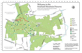
The Sourland Mountain Preserve is located on Sourland Mountain, in the Sourlands region of New Jersey. It is within Hillsborough Township and Montgomery Township of Somerset County. The largest donation of land was made by Norma Gilbert Farr, trustee of the Linus R. Gilbert Foundation. The Farr family has donated over 3,000 acres to the Sourland Mountain Preserve and the Somerset County Parks Commission.

<span class="mw-page-title-main">Geography of New Jersey</span> Overview of the geography of New Jersey

New Jersey is a state within the United States of America that lies on the north eastern edge of the North American continent. It shares a land border with the state of New York along the north, ratified by both states after the New York – New Jersey Line War, which is its only straight line border. New Jersey is slightly larger than the country of Kuwait.

<span class="mw-page-title-main">Sourland Mountain</span> Geological formation in New Jersey, US

Sourland Mountain is a 17 miles (27 km) long ridge in central New Jersey, extending from the Delaware River at Lambertville to the western end of Hillsborough Township near the community of Neshanic, through Montgomery Township and into Hopewell Township in Mercer County. It comprises the largest contiguous forest in Central Jersey, nearly 90 square miles (233 km2) in area. The highest point is only 568 feet (173 m) above sea level, but the way it rises steeply from the surrounding farmland has earned it the title of 'mountain'. The ridge itself sits within a larger area of rough terrain called The Sourlands.

The Newark Supergroup, also known as the Newark Group, is an assemblage of Upper Triassic and Lower Jurassic sedimentary rocks which outcrop intermittently along the United States East Coast. They were deposited in a series of Triassic basins approximately 190 million years ago as North America separated from Africa. The exposures extend from Nova Scotia to North Carolina. Related basins are also found underwater in the Bay of Fundy. The group is named for the city of Newark, New Jersey.

<span class="mw-page-title-main">Cushetunk Mountain</span> Mountain in New Jersey, US

Cushetunk Mountain is a ring shaped mountain in the U.S. state of New Jersey, located in Readington and Clinton Township in Hunterdon County. The Lenape Native Americans called the mountain "Cushetunk" meaning "place of hogs" after the wild hogs found there. In the 1960s, the valley at the heart of the mountain was dammed and filled with water to create Round Valley Reservoir. Today, the mountain and its accompanying lake act as a vital water supply to Central New Jersey, while at the same time providing numerous recreational opportunities to the region.

<span class="mw-page-title-main">Campgaw Mountain</span> Mountain in New Jersey, United States

Campgaw Mountain is the northernmost ridge of the volcanically formed Watchung Mountains, along the border of Franklin Lakes, Oakland, and Mahwah in Bergen County, New Jersey, United States. Located almost entirely within the bounds of Campgaw Mountain Reservation, the mountain offers numerous outdoor recreational opportunities, including the only ski slope in the Watchungs. Campgaw Mountain is commonly considered to be part of the greater Ramapo Mountains region, but the flora and geology of the mountain is quite different from the surrounding area and more closely resembles the nearby Preakness Range to the south.

<span class="mw-page-title-main">Palisades Sill</span>

The Palisades Sill is a Triassic, 200 Ma diabase intrusion. It extends through portions of New York and New Jersey. It is most noteworthy for The Palisades, the cliffs that rise steeply above the western bank of the Hudson River. The ideal location and accessibility of the sill, as well as its unique features, have generated much attention from nature enthusiasts, rock climbers, and geologists alike.

New Jersey is a very geologically and geographically diverse region in the United States' Middle Atlantic region, offering variety from the Appalachian Mountains and the Highlands in the state's northwest, to the Atlantic Coastal Plain region that encompasses both the Pine Barrens and the Jersey Shore. The state's geological features have impacted the course of settlement, development, commerce and industry over the past four centuries.

<span class="mw-page-title-main">Preakness Range</span>

The Preakness Range is a range of the trap rock Watchung Mountains on the western edge of the Newark Basin in northern New Jersey. A large portion of this range is included in High Mountain Park Preserve, offering miles of hiking trails with vistas overlooking New Jersey and New York City. The peaks of the Preakness Range, the highest of the Watchung Mountains, shelter endangered ecosystems, including perched wetlands and rare trap rock glade communities.

<span class="mw-page-title-main">Goffle Hill</span> Mountain range in New Jersey, USA

Goffle Hill, also referred to as Goffle Mountain and historically known as Totoway Mountain and Wagaraw Mountain, is a range of the trap rock Watchung Mountains on the western edge of the Newark Basin in northern New Jersey. The hill straddles part of the border of Bergen County and Passaic County, underlying a mostly suburban setting. While hosting patches of woodlands, perched wetlands, and traprock glades, the hill is largely unprotected from development. Extensive quarrying for trap rock has obliterated large tracts of the hill in North Haledon, and Prospect Park. Conservation efforts seeking to preserve undeveloped land, such as the local Save the Woods initiative (2007–present), are ongoing.

<span class="mw-page-title-main">Igneous rock</span> Rock formed through the cooling and solidification of magma or lava

Igneous rock, or magmatic rock, is one of the three main rock types, the others being sedimentary and metamorphic. Igneous rocks are formed through the cooling and solidification of magma or lava.

<span class="mw-page-title-main">Ramapo Fault</span>

The Ramapo Fault zone is a system of faults between the northern Appalachian Mountains and Piedmont areas to the east. Spanning more than 185 miles (298 km) in New York, New Jersey, and Pennsylvania, it is perhaps the best known fault zone in the Mid-Atlantic region, and some small earthquakes have been known to occur in its vicinity. Recently, public knowledge about the fault has increased, especially after the 1970s, when the fault's proximity to the Indian Point nuclear plant in New York was noted.

<span class="mw-page-title-main">Feltville Formation</span>

The Feltville Formation is a mapped bedrock unit primarily in New Jersey, with one known outlier in Pennsylvania and another one in New York. It is named for the Deserted Village of Feltville in Watchung Reservation, New Jersey, which is near where its type section was described by paleontologist Paul E. Olsen.

<span class="mw-page-title-main">Drakensberg Group</span> Jurassic geological group in Lesotho and South Africa

The Drakensberg Group is a geological group named after the Drakensberg mountain range where in its uppermost sections the rocks are found. The Drakensberg Group lies over most of Lesotho and localities in the Eastern Cape, KwaZulu-Natal, and Free State provinces of South Africa. It forms part of the greater Karoo Igneous Province, which occurs over an extensive area of southern Africa.

References

  1. 1 2 Kummel, Henry B. (1899). Annual Report of the State Geologist for the year 1898 – The Extension of the Newark System of Rocks. Trenton, NJ: MacCrellish & Quigley, State Printers. p. 54.
  2. Kodama, K.P., 1983. Magnetic and gravity evidence for a subsurface connection between the Palisades sill and the Ladentown basalts. Geological Society of America Bulletin, v. 94, no. 1, p. 151–158.
  3. 1 2 3 4 5 6 7 8 9 Olsen, P.E., 1980. The Latest Triassic and Early Jurassic Formations of the Newark Basin (Eastern North America, Newark Supergroup): Stratigraphy, Structure, and Correlation. New Jersey Academy of Science Bulletin, v. 25, no. 2, p. 25–51.
  4. Puffer, J.H., Block, K.A., Steiner, J.C., 2009. Transmission of Flood Basalts through a Shallow Crustal Sill and the Correlation of Sill Layers with Extrusive Flows: The Palisades Intrusive System and the Basalts of the Newark Basin, New Jersey, U.S.A. The Journal of Geology, volume 117, p. 139–155.
  5. Darton, Nelson Horatio. Bulletin of the United States Geological Survey No. 67 – The Relations of the Traps of the Newark System in the New Jersey Region. Government Printing Office, Washington, 1890. See Pages 53, Union Hill Trap. Available via Google Books
  6. Volkert, Richard A. Bedrock Geological Map of the Ramsey Quadrangle, Passaic and Bergen Counties, New Jersey and Rockland County, New York – Open File Map OFM 87. New Jersey Geological Survey, 2011. Available Online
  7. Mineral Resources Online Spatial Data – Preakness Basalt. U.S. Geological Survey. Accessed December 22, 2009.
  8. Darton, Nelson Horatio. Bulletin of the United States Geological Survey No. 67 – The Relations of the Traps of the Newark System in the New Jersey Region. Government Printing Office, Washington, 1890. See Page 66. Available via Google Books
  9. 1 2 Lewis, Volney J. Annual Report of the State Geologist of New Jersey for the Year 1907 – Part IV: Petrography of the Newark Igneous Rocks of New Jersey. John L. Murphy Publishing Company, Printers, Trenton, NJ, 1908. See Pages 166–167 Available via Google Books.
  10. 1 2 Kümmel, Henry B. Annual Report of the State Geologist of New Jersey for the Year 1897 – Part II: The Newark System. John L. Murphy Publishing Company, Printers, Trenton, NJ, 1898. See Pages 92–93 Available via Google Books.
  11. LeTourneau, Peter M. & Olsen, Paul E. (editors). “The Great Rift Valleys of Pangea in Eastern North America – Volume One: Tectonics Structure and Volcanism”. Columbia University Press, New York, 2003. ISBN   0-231-11162-2. See Page 41. Limited Preview available via Google Books.

Coordinates: 40°30′40″N74°51′58″W / 40.511°N 74.866°W / 40.511; -74.866