Clarks Knob

Last updated

Clarks Knob
Clarks Knob.jpg
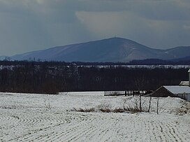
Clarks Knob in February 2008
Highest point
Elevation 2,316 ft (706 m)  NAVD 88 [1]
Coordinates 40°2′52″N77°45′2″W / 40.04778°N 77.75056°W / 40.04778; -77.75056 [1]
Geography
USA Pennsylvania relief location map.svg
Red triangle with thick white border.svg
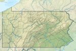
Clarks Knob
Location of Clarks Knob
Location Franklin County, Pennsylvania, U.S.
Parent range Blue Mountain [2]
Topo map USGS Roxbury (PA) Quadrangle [2]
Climbing
Easiest route Drive up gravel road [1]

Clarks Knob is a summit in Franklin County, Pennsylvania. [3] It is the highest point on Blue Mountain, the eastern front range of Pennsylvania's Ridge and Valley Appalachians region. [2]

Geography

Clarks Knob's northeast-southwest running summit ridge forms the boundary of the Susquehanna River and Potomac River drainages. [2] It stands over 1,600 feet (488 m) above the town of Chambersburg and the Great Appalachian Valley. This mountain is protected within the Buchanan State Forest. [2]

References

  1. 1 2 3 "Clarks Knob". NGS Data Sheet. National Geodetic Survey, National Oceanic and Atmospheric Administration, United States Department of Commerce . Retrieved February 8, 2009.
  2. 1 2 3 4 5 "Clarks Knob". Peakbagger.com. Retrieved February 7, 2009.
  3. "Clarks Knob". Geographic Names Information System . United States Geological Survey, United States Department of the Interior . Retrieved February 8, 2009.