
Spruce Knob, at 4,863 feet (1,482 m), is the highest point in the state of West Virginia and the summit of Spruce Mountain, the highest peak in the Allegheny Mountains.
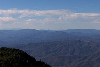
The Unaka Range is a mountain range on the border of Tennessee and North Carolina, in the southeastern United States. It is a subrange of the Appalachian Mountains and is part of the Blue Ridge Mountains physiographic province. The Unakas stretch approximately from the Nolichucky River to the south to the Watauga River to the north. The Unakas include the prominent Roan Highlands, where several summits rise above 6,000 feet. The Iron Mountains border the Unakas to the north, and the Bald Mountains border the Unakas opposite the Nolichucky to the south. The name unaka is rooted in the Cherokee term unega, meaning "white".

Bald Knob is the highest summit of Back Allegheny Mountain in Pocahontas County, West Virginia and is part of Cass Scenic Railroad State Park. At an altitude of 4,843 feet (1,476 m) above sea level, Bald Knob is the third-highest point in West Virginia and the Allegheny Mountains.

Dick's Knob or Dicks Knob, with an elevation of 4,620 feet (1,408 m), is the third-highest peak in the State of Georgia if using a 200 ft. prominence rule. It is located in Rabun County, Georgia within the Southern Nantahala Wilderness and is the second-highest mountain in the county.

Double Spring Knob, with an elevation of 4,280 feet (1,305 m), is tied with Coosa Bald as the tenth-highest peak in Georgia, USA. It is located in two Georgia counties - Rabun and Towns. It is located within the boundaries of the Chattahoochee National Forest. The Appalachian Trail passes below the knob to the east. This mountain is also known as Kelly Knob.

Young Lick is a mountain that lies in three Georgia counties, Habersham, Rabun and Towns. Its summit - Young Lick Knob, elevation 3,809 feet (1,161 m), is one of Habersham County's highest points. Young Lick Knob is crossed by the Appalachian Trail.
Rocky Knob is a name used to describe eight different mountain peaks located in the North Georgia mountains that are scattered among four different Georgia counties.

Coosa Bald, with an elevation of 4,280 feet (1,300 m), is tied with Double Spring Knob as the tenth-highest peak in Georgia. It is located in Union County and is the third-highest mountain in the county, behind Blood Mountain and Slaughter Mountain. Coosa Bald is located in the Chattahoochee National Forest and its peak is crossed by the Duncan Ridge Trail, a trail that connects with the Benton MacKaye Trail and the Appalachian Trail.

Waterrock Knob is a mountain peak in the U.S. state of North Carolina. It is the highest peak in the Plott Balsams and is the 16th-highest mountain in the Eastern United States.

Blue Knob is a Pennsylvania summit with a broad dome that is the northernmost 3,000-footer in the range of Allegheny Mountains. It is the highest point in Bedford County.

Martin Hill is a mountain ridge which connects Tussey Mountain to its east and Evitts Mountain to its west. Martin Hill is located in the Martin Hill Wild Area, which is a part of the Buchanan State Forest, in Bedford County, Pennsylvania. The summit of Martin Hill is one of the few in the Commonwealth which is void of any towers or transmitters; such equipment is located instead on a lesser nearby summit in the same mountain complex. Martin Hill is the second highest in Pennsylvania's Ridge and Valley Appalachians, the highest being Wills Mountain to its west at 2,780 ft (850 m). The highest mountains in the Commonwealth are located in the Allegheny Mountains in western Pennsylvania, where Mount Davis stands at 3,213 ft (979 m).
Pine Knob is a peak in the Allegheny Mountains of Pennsylvania. This mountain is a satellite peak of its larger neighbor Blue Knob. At 2,704 ft (824 m) above sea level it is the lesser in elevation when compared to Schaefer Head (2,950 ft), Round Knob (2,791 ft), Cattle Knob (2,842 ft) and Ritchey Knob (2,865 ft). The latter mountain is connected to Pine Knob, the saddle elevation between the peaks is 2,597 ft (792 m)

Back Allegheny Mountain is a long mountain ridge in eastern West Virginia. It is part of the Shavers Fork Mountain Complex in the Allegheny Range of the Appalachians.

Kinton Knob is a peak in Bedford County, Pennsylvania. Kinton Knob marks the north end of Wills Mountain where it abruptly ends just southwest of the town of Bedford. The mountain has an array of communication towers on its summit. Limited views are available from the top, especially in the winter season, of Blue Knob to the north and the Allegheny Front to the west.
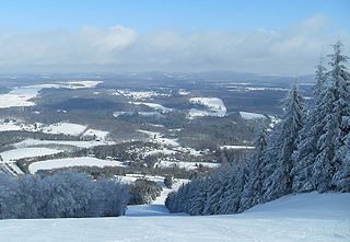
Elk Hill, also known as North Knob at its highest point or Elk Mountain, is a mountain in Herrick Township, Susquehanna County, Pennsylvania. It is the highest peak in eastern Pennsylvania, east of the Susquehanna River, as well as the highest peak on the Allegheny Plateau. Elk Hill rises conspicuously above the surrounding landscape. The mountain actually has two peaks; the main summit of North Knob is 2,693 feet (821 m), and the lower summit known as South Knob is 2,602 feet (793 m). It is home to Elk Mountain Ski Area which has a 1,000 feet (305 m) vertical drop and 27 ski trails.
Ritchey Knob is a summit located on the Blue Knob massif. This mountain is connected to Pine Knob and forms the northern most summits of the massif.

Herman Point is a satellite of Blue Knob mountain in Pennsylvania and one of the few summits in the state which exceed 3,000 feet (914 m) feet. This summit is located in the Blue Knob State Park and serves as the trailhead for the "Lost Turkey Trail". Herman Point is also the site of FAA towers and the old fire lookout which has since been removed.

Miller Mountain is a peak located in Wyoming County, Pennsylvania. This mountain is one of the more recognizable peaks in the Endless Mountains region of the Commonwealth. Miller Mountain is a "stand alone" peak from the rest of the Allegheny Plateau. The Susquehanna River flows past the mountain where the slopes rise to over 1,600 feet (490 m) above the river banks and the town of Tunkhannock.


