Bedford County is a county in the Commonwealth of Pennsylvania. As of the 2020 census, the population was 47,577. The county seat is Bedford. The county is part of the Southwest Pennsylvania region of the state.

Bedford Township is a township in Bedford County, Pennsylvania, United States. The population was 5,107 at the 2020 census.

The Allegheny Plateau is a large dissected plateau area of the Appalachian Mountains in western and central New York, northern and western Pennsylvania, northern and western West Virginia, and eastern Ohio. It is divided into the unglaciated Allegheny Plateau and the glaciated Allegheny Plateau.

The Cumberland Mountains are a mountain range in the southeastern section of the Appalachian Mountains. They are located in western Virginia, southwestern West Virginia, the eastern edges of Kentucky, and eastern middle Tennessee, including the Crab Orchard Mountains. Their highest peak, with an elevation of 4,223 feet (1,287 m) above mean sea level, is High Knob, which is located near Norton, Virginia.
The Potomac Highlands of West Virginia centers on five West Virginian counties in the upper Potomac River watershed in the western portion of the state's Eastern Panhandle, bordering Maryland and Virginia. Because of geographical proximity, similar topography and landscapes, and shared culture and history, the Potomac Highlands region also includes Pocahontas, Randolph, and Tucker counties, even though they are in the Monongahela River or New River watersheds and not that of the Potomac River.

Bald Eagle Mountain – once known locally as Muncy Mountain – is a stratigraphic ridge in the Ridge-and-Valley Appalachians of central Pennsylvania, United States, running east of the Allegheny Front and northwest of Mount Nittany. It lies along the southeast side of Bald Eagle Creek and south of the West Branch Susquehanna River, and is the westernmost ridge in its section of the Ridge-and-Valley Appalachians. The ridge line separates the West Branch Susquehanna Valley from the Nippenose and White Deer Hole valleys, and Bald Eagle Valley from Nittany Valley.

North Fork Mountain is a quartzite-capped mountain ridge in the Ridge and Valley physiographic province of the Allegheny Mountains, also known as the High Alleghenies or Potomac Highlands, of eastern West Virginia. Kile Knob, at 4,588 feet, is the mountain's highest point, and Panther Knob and Pike Knob are nearly as high.
Brush Mountain is a stratigraphic ridge in the Appalachian Mountains of central Pennsylvania, United States, lying east of the Allegheny Front and west of Tussey Mountain. It runs along the southeast side of the Little Juniata River and forms a horseshoe around Sinking Run, and is the westernmost ridge in its section of the Ridge-and-valley Appalachians. The western ridge line separates the Logan Valley from the Sinking Valley.

The Cumberland Narrows is a water gap in western Maryland in the United States, just west of Cumberland. Wills Creek cuts through the central ridge of the Wills Mountain Anticline at a low elevation here between Wills Mountain to the north and Haystack Mountain to the south. Cliffs and talus of the two mountains' Tuscarora quartzite caprock are prominent within the Narrows. A prominent rocky outcropping at the south end of Wills Mountain in the Cumberland Narrows is known as Lover's Leap.

Tussey Mountain is a stratigraphic ridge in central Pennsylvania, United States, trending east of the Bald Eagle, Brush, Dunning and Evitts Mountain ridges. Its southern foot just crosses the Mason–Dixon line near Flintstone, Maryland, running north 130 km (80 mi) to the Seven Mountains of central Pennsylvania, near Tusseyville, making it one of the longest named ridges in this section of the Ridge-and-valley Appalachians.

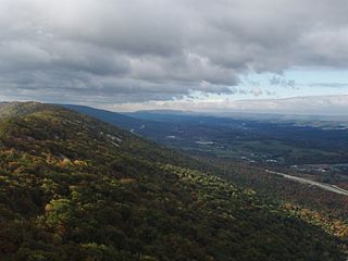
The Geology of Pennsylvania consists of six distinct physiographic provinces, three of which are subdivided into different sections. Each province has its own economic advantages and geologic hazards and plays an important role in shaping everyday life in the state. From the southeast corner to the northwest corner of the state, they include: the Atlantic Plain Province, the Piedmont Province, the New England Province, the Ridge and Valley Province, the Appalachain Province, and the Central Lowlands Province.

Big Mountain is the high point on the Tuscarora Mountain ridge in south central Pennsylvania in the United States. The 2,458-foot (749 m) summit is located in the Buchanan State Forest and offers a viewshed that is one of the more stunning in the Commonwealth.

The Silurian Tuscarora Formation — also known as Tuscarora Sandstone or Tuscarora Quartzite — is a mapped bedrock unit in Pennsylvania, Maryland, West Virginia, and Virginia, US.

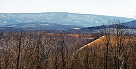
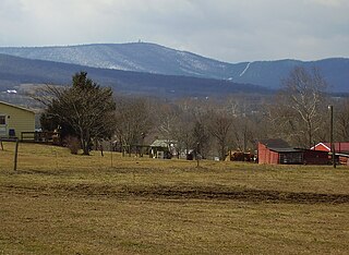
Bedford County, Pennsylvania is situated along the western border of the Ridge and Valley physiographic province, which is characterized by folded and faulted sedimentary rocks of early to middle Paleozoic age. The northwestern border of the county is approximately at the Allegheny Front, a geological boundary between the Ridge and Valley Province and the Allegheny Plateau.

Parnell Knob is a mountain in the Ridge and Valley Appalachians region of south central Pennsylvania. This knob rises above the village of St. Thomas, where Front Mountain and Broad mountain come together. It is a feature sculptured by the hard dense Tuscarora quartzite of the Silurian age. Parnell Knob is conspicuous in that it rises abruptly above the relatively level Great Appalachian Valley.
Cross Mountain is the highest peak in the Bear Pond Mountains, a sub range of the Appalachian Mountains. This grouping of mountains straddle the Maryland and Pennsylvania border.

The Bear Pond Mountains are a subrange in the Appalachian Mountains, that straddle Pennsylvania and Maryland in the United States. These mountains are a part of the Ridge and Valley Appalachians and reach their highest point at Cross Mountain (Pennsylvania) 2,062 feet (628 m). A unique geologic feature known as the "Punchbowl" occurs in this range. This feature was created by the weathered shales of the Ordovician age in the center of a south-plunging anticline, having been eroded to expose a large amphitheater-like feature (punchbowl). Cross and Hearthstone Mountain are made of hard resistant quartzite of the Tuscarora Formation of the Silurian age, which form the walls of the bowl.

Allegheny Mountain is a stratigraphic ridge that extends northeast to southwest from south of Blue Knob to a saddle point at the Savage Mountain anticline. It merges with Negro Mountain just north of the Cambria County line where the Berlin-Salisbury basin expires.
The Ridgeley sandstone is a sandstone or quartzite of Devonian age found in the Appalachian Mountains of Pennsylvania, Maryland, West Virginia, and Virginia, United States. The Ridgeley is fine-grained, siliceous, calcareous in its lower strata, sometimes fossiliferous, and sometimes locally pebbly or conglomeritic. Varying in thickness from 12 to 500 feet, this rock slowly erodes into white quartz sand that often washes or blows away, but sometimes accumulates at large outcrops. When freshly broken, the rock is white, but outcrop surfaces are often stained yellowish by iron oxides.

Dunning Mountain is a stratigraphic ridge in central Pennsylvania, United States. The mountain's north end is at McKee Gap, which separates it from Short Mountain, and where Halter Creek flows westward towards the Frankstown Branch of the Juniata River. The south end of the mountain is contiguous with Evitts Mountain, but is marked by a sharp bend to the east. The valley formed by the bend is known as "The Kettle," and the broad valley to the east of Dunning Mountain is called Morrisons Cove. The town of Roaring Spring is located at the north end of the mountain on the east side.