
The Great Valley, also called the Great Appalachian Valley or Great Valley Region, is one of the major landform features of eastern North America. It is a gigantic trough—a chain of valley lowlands—and the central feature of the Appalachian Mountain system. The trough stretches about 1,200 miles (1,900 km) from Quebec to Alabama and has been an important north-south route of travel since prehistoric times.

The Delaware Water Gap is a water gap on the border of the U.S. states of New Jersey and Pennsylvania where the Delaware River cuts through a large ridge of the Appalachian Mountains. The gap constitutes the southern portion of the Delaware Water Gap National Recreation Area, which is used primarily for recreational purposes, such as rafting, canoeing, swimming, fishing, hiking, and rock climbing.
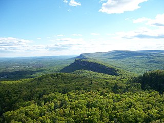
The Shawangunk Ridge, also known as the Shawangunk Mountains or The Gunks, is a ridge of bedrock in Ulster County, Sullivan County and Orange County in the state of New York, extending from the northernmost point of New Jersey to the Catskill Mountains. Shawangunk Ridge is the continuation of the long, easternmost ridge of the Appalachian Mountains; the ridge is known as Kittatinny Mountain in New Jersey, and as Blue Mountain as it continues through Pennsylvania. This ridge constitutes the western border of the Great Appalachian Valley.

The New York–New Jersey Trail Conference (NYNJTC) is a volunteer-based federation of approximately 10,000 individual members and about 100 member organizations. The conference coordinates the maintenance of 2,000 miles of foot trails around the New York metropolitan area, from the Delaware Water Gap, north to beyond the Catskill Mountains, including the Appalachian Trail through New York and New Jersey. It also works to protect open space and publishes books and trail maps. The organization's headquarters are at 600 Ramapo Valley Road, Mahwah, New Jersey.

Worthington State Forest is a state forest located within the Delaware Water Gap National Recreation Area, just above the water gap, in Warren County, New Jersey. It covers an area of 6,660 acres (27.0 km2) and stretches for more than 7 miles (11 km) along the Kittatinny Ridge near Columbia. The park offers hiking, camping and canoeing and kayaking on the Delaware. There are some twenty miles of hiking trails within the park, including seven miles of the Appalachian Trail, which passes through the park. The park is operated and maintained by the New Jersey Division of Parks and Forestry.

Kittatinny Mountain is a long ridge traversing across northwestern New Jersey running in a northeast-southwest axis, a continuation across the Delaware Water Gap of Pennsylvania's Blue Mountain Ridge. It is the first major ridge in the far northeastern extension of the Ridge and Valley province of the Appalachian Mountains, and reaches its highest elevation, 1,803 feet, at High Point in Montague Township. Kittatinny Mountain forms the eastern side of Wallpack Valley; the western side comprises the Wallpack Ridge (highest elevation: 928 feet above sea level.

Blue Mountain Ridge, Blue Mountain, or the Blue Mountains of Pennsylvania is part of the geophysical makeup of the Ridge-and-Valley Appalachians in the U.S. state of Pennsylvania. It is a ridge that forms the southern and eastern edge of the Appalachian mountain range spanning over 255 miles (410 km) from the Delaware Water Gap as it cuts across the eastern half of the state on a slight diagonal from New Jersey tending southerly until it turns southerly curving into Maryland, and beyond.
Old Mine Road is a road in New Jersey and New York said to be one of the oldest continuously used roads in the United States of America. At a length of 104 miles (167 km), it stretches from the Delaware Water Gap National Recreation Area to the vicinity of Kingston, New York.

The Skylands Region is a region and marketing area of the State of New Jersey located in the Northern and Central part of the state. It is one of six tourism regions established by the New Jersey State Department of Tourism, the others being the Gateway Region, Greater Atlantic City Region, the Southern Shore Region, the Delaware River Region and the Shore Region. The area officially encompasses Hunterdon, Morris, Somerset, Sussex and Warren counties; the northwestern part of the Passaic County fits in with the Skylands Region, but it is part of the Gateway Region and not the Skylands Region. One could also say that the western most part of Bergen is also part of the skylands. The area features uplifted land, rolling hills and mountains characteristic of North Jersey. The region contains 60,000 acres of state parkland, and a diverse geography filled with lakes, rivers and picturesque hills.
County Route 521, abbreviated CR 521, is a county highway in the U.S. state of New Jersey. The highway extends 43.71 miles from High Street in Hope Township to the New York state line in Montague Township.

Stokes State Forest is a state park located in Sandyston, Montague and Frankford in Sussex County, New Jersey, United States. Stokes comprises 16,447 acres (66.56 km2) of mountainous woods in the Kittatinny Mountains, extending from the southern boundary of High Point State Park southwestward to the eastern boundary of the Delaware Water Gap National Recreation Area. The park is operated and maintained by the New Jersey Division of Parks and Forestry.
The Appalachian National Scenic Trail spans fourteen U.S. states during its roughly 2,200 miles (3,500 km)-long journey: Georgia, North Carolina, Tennessee, Virginia, West Virginia, Maryland, Pennsylvania, New Jersey, New York, Connecticut, Massachusetts, Vermont, New Hampshire, and Maine. It begins at Springer Mountain, Georgia, and follows the ridgeline of the Appalachian Mountains, crossing many of its highest peaks and running with only a few exceptions almost continuously through wilderness before ending at Mount Katahdin, Maine.

The Kittatinny Valley is a section of the Great Appalachian Valley in Sussex and Warren counties in northwestern New Jersey that is bounded on the west by Kittatinny Mountain, and in the east by the Highlands region. The valley is roughly 39 miles long and average breadth of 10 miles through the center of Sussex and Warren Counties.
Sunrise Mountain is a peak of the Kittatinny Mountains in Sussex County, New Jersey, United States. The mountain is 1,650 feet (503 m) tall, and overlooks Beemerville to the east. It lies along the Appalachian Trail in Stokes State Forest.
Rattlesnake Mountain is a peak of the Kittatinny Mountains in Sussex County, New Jersey, United States. The mountain stands 1,489 feet (454 m) high. It lies along the Appalachian Trail in the Delaware Water Gap National Recreation Area. Located near the junction of Mullins Rd. (unmarked) and the Trail. Rattlesnakes like any of the rocky areas of the Kittatinny Ridge, for sunning themselve
Bird Mountain is a peak of the Kittatinny Mountains in Sussex County, New Jersey, United States. The mountain is 1,500 feet (457 m) tall. It lies near the Appalachian Trail in the Delaware Water Gap National Recreation Area, and overlooks Quick's Pond to the east.
Blue Mountain is a peak of the Kittatinny Mountains in Sussex County, New Jersey, United States. The mountain is 1,420 feet (433 m) in height. It lies along the Appalachian Trail in Stokes State Forest, overlooking Quick's Pond to the south, and Mecca Lake to the southeast.
