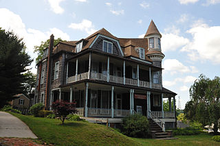
Atlantic Highlands is a borough in Monmouth County, New Jersey, in the Bayshore Region. As of the 2010 United States Census, the borough's population was 4,385,, a decline of 320 (-6.8%) from the 4,705 in the 2000 Census, which had in turn increased by 76 (+1.6%) from the 4,629 in the 1990 Census.

Schooley's or, officially, Schooleys Mountain is a mountain ridge in northern New Jersey that stretches from Lake Hopatcong in the north to Hampton in the south. It is centrally located within the southern Highlands, positioned almost equidistantly from the Kittatinny Valley in the west and the Piedmont plateau in the east. Schooley's Mountain is also one of the largest ridges in a group of geologically similar and parallel mountains, which include Allamuchy Mountain, Pohatcong Mountain, Scotts Mountain, and Jenny Jump Mountain.

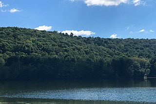
Cushetunk Mountain is a ring shaped mountain in the U.S. state of New Jersey, located in Readington and Clinton Township in Hunterdon County. The Lenape Native Americans called the mountain "Cushetunk" meaning "place of hogs" after the wild hogs found there. In the 1960s, the valley at the heart of the mountain was dammed and filled with water to create Round Valley Reservoir. Today, the mountain and its accompanying lake act as a vital water supply to Central New Jersey, while at the same time providing numerous recreational opportunities to the region.

Pochuck Mountain is a ridge in the New York-New Jersey Highlands region of the Appalachian Mountains. Pochuck Mountain's summit and most of its peaks lie within Vernon Township, Sussex County, New Jersey, although the south-western portion of the ridge lies within Hardyston Township, and the north-eastern tip of the ridge extends over the New York state line into Orange County. The ridge marks the eastern edge of the Great Appalachian Valley, and it divides the watersheds of the Wallkill River and its tributary Pochuck Creek. The two rivers meet at Pochuck Neck, marking the terminus of the ridge.
The Reading Prong is a physiographic subprovince of the New England Uplands section of the New England province of the Appalachian Highlands. The prong consists of mountains made up of crystalline metamorphic rock.

Musconetcong Mountain is a ridge in the Highlands region of New Jersey running south of and parallel to the Musconetcong River. The ridge travels through Alexandria, Holland, Bethlehem and Lebanon Township.

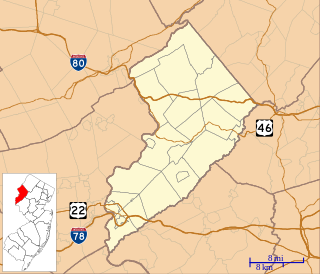
Mount Salem Vineyards is a boutique winery in the Pittstown section of Alexandria Township in Hunterdon County, New Jersey, United States. Formerly a produce, grain, and dairy farm, the vineyard was first planted in 2005, and opened to the public in 2010. Peter Leiter, the proprietor of Mount Salem, founded the Appalachian Highlands Vinifera Society, whose mission is to enhance the quality of wine grape growing and winemaking in Northern New Jersey. Mount Salem has 7 acres of grapes under cultivation, and produces 1,000 cases of wine per year. The winery is located at over 600 feet above sea level on Mount Salem, the mountain for which the farm is named.

The New York – New Jersey Highlands is a geological formation composed primarily of Precambrian igneous and metamorphic rock running from the Delaware River near Musconetcong Mountain, northeast through the Skylands Region of New Jersey along the Bearfort Ridge and the Ramapo Mountains, Sterling Forest, Harriman and Bear Mountain State Parks in New York, to the Hudson River at Storm King Mountain. The northern region is also known as the Hudson Highlands and the southern as the New Jersey Highlands. A broader definition would extend the region west to Reading, Pennsylvania, and east to the Housatonic River in Connecticut, encompassing the Reading Prong.
Watnong Mountain is a mountain in Morris County, New Jersey. The major peak rises to 965 feet (294 m). It is located in Parsippany-Troy Hills Township and overlooks Morris Plains to the east. It is part of the New York–New Jersey Highlands of the Reading Prong.
Allamuchy Mountain is a mountain in Sussex and Warren Counties, New Jersey. The major peak rises to 1,222 feet (372 m), and is located in Byram Township. The mountain also covers portions of Allamuchy Township in Warren County and Green Township in Sussex County. It overlooks the Musconetcong River to the southeast, and forms part of the divide between that river and the Pequest to the northwest. It is part of the New York–New Jersey Highlands of the Reading Prong.
Baldpate Mountain is a peak of Upper Pohatcong Mountain in Warren County, New Jersey, United States. This peak rises to 1,165 feet (355 m), and is located in Mansfield Township. It is part of the New York–New Jersey Highlands of the Reading Prong.
County House Mountain is a mountain in Warren County, New Jersey. The main peak rises to 1,142 feet (348 m), and is located in Mansfield Township. County House Mountain is separated from Oxford Mountain to the southwest at Sykes Gap, and is itself bifurcated at Stewart Gap; it forms a part of the divide between Pohatcong Creek and the Pequest River. It is part of the New York–New Jersey Highlands of the Appalachian Mountains.
Mount No More is a mountain in Warren County, New Jersey. The summit rises to 1,150 feet (351 m), and is located in White Township. It is part of the New York–New Jersey Highlands of the Appalachian Mountains.
Danville Mountain is a mountain in Warren County, New Jersey. The summit rises to 1,122 feet (342 m), and is located in Liberty Township. It is part of the New York–New Jersey Highlands of the Appalachian Mountains, although somewhat isolated to the west of the main body of the Highlands.
High Rock Mountain is a mountain in Warren County, New Jersey. The summit rises to 889 feet (271 m), and is located on the boundary of Liberty and White Townships. It is part of the New York–New Jersey Highlands of the Appalachian Mountains, although somewhat isolated to the west of the main body of the Highlands.

Jenny Jump Mountain is a mountain in Warren County, New Jersey. The summit rises to 1,129 feet (344 m); the mountain is within Frelinghuysen, Hope, Independence and Liberty Townships. It is part of the New York–New Jersey Highlands of the Appalachian Mountains, although somewhat isolated to the west of the main body of the Highlands.
Marble Mountain is a mountain in Warren County, New Jersey. The summit rises to 771 feet (235 m), and is located in Harmony and Lopatcong Townships, overlooking the Delaware River; along with Chestnut Hill on the Pennsylvania side, Marble Mountain forms Weygadt Gap or the Little Water Gap.
Oxford Mountain is a mountain in Warren County, New Jersey. The main peak rises to 955 feet (291 m), and is located in Oxford, Washington and Mansfield Townships. Oxford Mountain is separated from County House Mountain to the northeast at Sykes Gap, and forms a part of the divide between Pohatcong Creek and the Pequest River. It is part of the New York–New Jersey Highlands of the Appalachian Mountains.
Scotts Mountain is a mountain in Warren County, New Jersey. The mountain covers portions of Harmony, Lopatcong, Franklin and Washington Townships; the main summit rises to 1,086 feet (331 m), and is located in Harmony. It is part of the New York–New Jersey Highlands of the Appalachian Mountains, although somewhat isolated to the west of the main body of the Highlands.


