The Delaware River is a major river on the Atlantic coast of the United States. It drains an area of 14,119 square miles (36,570 km2) in five U.S. states: Delaware, Maryland, New Jersey, New York, Pennsylvania. Rising in two branches in New York state's Catskill Mountains, the river flows 419 miles (674 km) into Delaware Bay where its waters enter the Atlantic Ocean near Cape May in New Jersey and Cape Henlopen in Delaware. Not including Delaware Bay, the river's length including its two branches is 388 miles (624 km). The Delaware River is one of nineteen "Great Waters" recognized by the America's Great Waters Coalition.

The Great Valley, also called the Great Appalachian Valley or Great Valley Region, is one of the major landform features of eastern North America. It is a gigantic trough—a chain of valley lowlands—and the central feature of the Appalachian Mountain system. The trough stretches about 1,200 miles (1,900 km) from Quebec to Alabama and has been an important north-south route of travel since prehistoric times.

The Delaware Water Gap is a water gap on the border of the U.S. states of New Jersey and Pennsylvania where the Delaware River cuts through a large ridge of the Appalachian Mountains. The gap constitutes the southern portion of the Delaware Water Gap National Recreation Area, which is used primarily for recreational purposes, such as rafting, canoeing, swimming, fishing, hiking, and rock climbing.

Mount Tammany is the southernmost peak of the Kittatinny Mountains in Knowlton Township, Warren County, New Jersey, United States. It is 1,526 feet (465 m) tall, and forms the east side of the Delaware Water Gap. Across the Gap is Mount Minsi, on the Pennsylvania side of the river. The mountain is named after the Lenni Lenape chief Tamanend. It lies along the Appalachian Trail in Worthington State Forest. The summit can be hiked by the Mount Tammany Trail ascending the western slopes. This trail head is accessible from Interstate 80.

Blue Mountain Ridge, Blue Mountain, or the Blue Mountains of Pennsylvania is part of the geophysical makeup of the Ridge-and-Valley Appalachians in the U.S. state of Pennsylvania. It is a ridge that forms the southern and eastern edge of the Appalachian mountain range spanning over 255 miles (410 km) from the Delaware Water Gap as it cuts across the eastern half of the state on a slight diagonal from New Jersey tending southerly until it turns southerly curving into Maryland, and beyond.
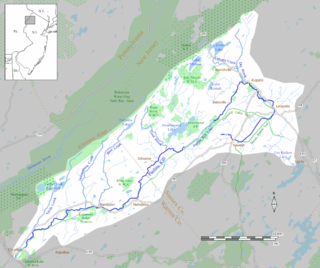
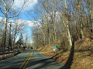
The Paulinskill is a 41.6-mile (66.9 km) tributary of the Delaware River in northwestern New Jersey in the United States. With a long-term median flow rate of 76 cubic feet of water per second (2.15 m³/s), it is New Jersey's third-largest contributor to the Delaware River, behind the Musconetcong River and Maurice River. The Paulinskill drains an area of 176.85 square miles (458.0 km2) across portions of Sussex and Warren counties and 11 municipalities. The Paulinskill flows north from its source near Newton, and then turns southwest. The river sits in the Ridge and Valley geophysical province.

The Skylands Region is a region and marketing area of the State of New Jersey located in the Northern and Central part of the state. It is one of six tourism regions established by the New Jersey State Department of Tourism, the others being the Gateway Region, Greater Atlantic City Region, the Southern Shore Region, the Delaware River Region and the Shore Region. The area officially encompasses Hunterdon, Morris, Somerset, Sussex and Warren counties; the northwestern part of the Passaic County fits in with the Skylands Region, but it is part of the Gateway Region and not the Skylands Region. One could also say that the western most part of Bergen is also part of the skylands. The area features uplifted land, rolling hills and mountains characteristic of North Jersey. The region contains 60,000 acres of state parkland, and a diverse geography filled with lakes, rivers and picturesque hills.

New Jersey is a state within the United States of America that lies on the north eastern edge of the North American continent. It shares a land border with the state of State of New York along the north, ratified by both states after the New York – New Jersey Line War. New Jersey is slightly larger than the country of Kuwait.

The Geology of Pennsylvania consists of six distinct physiographic provinces, three of which are subdivided into different sections. Each province has its own economic advantages and geologic hazards and plays an important role in shaping everyday life in the state. They are: the Atlantic Coastal Plain Province, the Piedmont Province, the New England Province, the Ridge and Valley Province, the Appalachian Plateau Province, and the Central Lowlands Province.

The Silurian Shawangunk Formation is a mapped bedrock unit in eastern Pennsylvania, New Jersey, and New York. It is named for the Shawangunk Ridge for which it is the dominant rock type. The division of the Shawangunk between the Tuscarora Formation and Clinton Group has not been conclusively determined. The shift of nomenclature currently has the divide between Hawk Mountain and Lehigh Gap.
New Jersey is a very geologically and geographically diverse region in the United States' Middle Atlantic region, offering variety from the Appalachian Mountains and the Highlands in the state's northwest, to the Atlantic Coastal Plain region that encompasses both the Pine Barrens and the Jersey Shore. The state's geological features have impacted the course of settlement, development, commerce and industry over the past four centuries.
The Reading Prong is a physiographic subprovince of the New England Uplands section of the New England province of the Appalachian Highlands. The prong consists of mountains made up of crystalline metamorphic rock.

The Kittatinny Valley is a section of the Great Appalachian Valley in Sussex and Warren counties in northwestern New Jersey that is bounded on the west by Kittatinny Mountain, and in the east by the Highlands region. The valley is roughly 39 miles long and average breadth of 10 miles through the center of Sussex and Warren Counties.

The Minisink or Minisink Valley is a loosely defined geographic region of the Upper Delaware River valley in northwestern New Jersey, northeastern Pennsylvania and New York.

Wallpack Ridge is a mountain located in the Ridge and Valley Appalachians physiographic province in Sussex County in northwestern New Jersey. Oriented northeast to southwest, Wallpack Ridge spans 25 miles (40 km) from Montague Township south of Port Jervis, New York to the Walpack Bend in the Delaware River near Flatbrookville in Walpack Township. It is a narrow ridge ranging between 0.67 miles (1.08 km) to 1.7 miles (2.7 km) in width, and its highest elevation reaches 928 feet (283 m) above sea level. The ridge separates the Wallpack Valley from the valley of the Delaware River, and contains the watershed of the Flat Brook and its main tributaries Big Flat Brook and Little Flat Brook.
County House Mountain is a mountain in Warren County, New Jersey. The main peak rises to 1,142 feet (348 m), and is located in Mansfield Township. County House Mountain is separated from Oxford Mountain to the southwest at Sykes Gap, and is itself bifurcated at Stewart Gap; it forms a part of the divide between Pohatcong Creek and the Pequest River. It is part of the New York–New Jersey Highlands of the Appalachian Mountains.
Oxford Mountain is a mountain in Warren County, New Jersey. The main peak rises to 955 feet (291 m), and is located in Oxford, Washington and Mansfield Townships. Oxford Mountain is separated from County House Mountain to the northeast at Sykes Gap, and forms a part of the divide between Pohatcong Creek and the Pequest River. It is part of the New York–New Jersey Highlands of the Appalachian Mountains.
Rattlesnake Mountain is a peak of the Kittatinny Mountains in Sussex County, New Jersey, United States. The mountain stands 1,489 feet (454 m) high. It lies along the Appalachian Trail in the Delaware Water Gap National Recreation Area. Located near the junction of Mullins Rd. (unmarked) and the Trail. Rattlesnakes like any of the rocky areas of the Kittatinny Ridge, for sunning themselve
Chestnut Hill is a low mountain in Northampton County, Pennsylvania. The main peak rises to 722 feet (220 m), and is located in Forks Township; the southern slopes extend into the City of Easton where it is known as College Hill in allusion to Lafayette College.