
The Watchung Mountains are a group of three long low ridges of volcanic origin, between 400 and 500 feet high, lying parallel to each other in northern New Jersey in the United States. The Watchung Mountains are known for their numerous scenic vistas overlooking New York City, Newark and New Jersey skylines, as well as their isolated ecosystems containing rare plants, endangered wildlife, rich minerals, and globally imperiled trap rock glade communities. The ridges traditionally contained the westward spread of urbanization, forming a significant geologic barrier beyond the piedmont west of the Hudson River; the town of Newark, for example, once included lands from the Hudson to the base of the mountains. Later treaties moved the boundary to the top of the mountain, to include the springs.

Stony Brook, also known as Stoney Brook, is a tributary of the Millstone River in Hunterdon and Mercer counties, New Jersey, in the United States.
Beden Brook, also Bedens Brook, Beden's Brook, or Beeden's Brook, is a tributary of the Millstone River in central New Jersey in the United States.

Snake Hill is an igneous rock intrusion jutting up from the floor of the Meadowlands in southern Secaucus, New Jersey, at a bend in the Hackensack River. It was largely obliterated in the 1960s by quarrying that reduced the height of some sections by one-quarter and the area of its base by four fifths. The diabase rock was used as building material in growing areas like Jersey City. The remnant of the hill is the defining feature of Laurel Hill County Park. The high point, a 203-foot graffiti-covered inselberg rock formation, is a familiar landmark to travelers on the New Jersey Turnpike's Eastern Spur, which skirts the hill's southern edge. The crest of the hill's unusual, sloping ridge is about 150 feet high.

The Skylands Region is a region and marketing area of the State of New Jersey located in the Northern and Central part of the state. It is one of six tourism regions established by the New Jersey State Department of Tourism, the others being the Gateway Region, Greater Atlantic City Region, the Southern Shore Region, the Delaware River Region and the Shore Region. The area officially encompasses Hunterdon, Morris, Somerset, Sussex and Warren counties; the northwestern part of the Passaic County fits in with the Skylands Region, but it is part of the Gateway Region and not the Skylands Region. One could also say that the westernmost part of Bergen is also part of the skylands. The area features uplifted land, rolling hills and mountains characteristic of North Jersey. The region contains 60,000 acres of state parkland, and a diverse geography filled with lakes, rivers and picturesque hills.
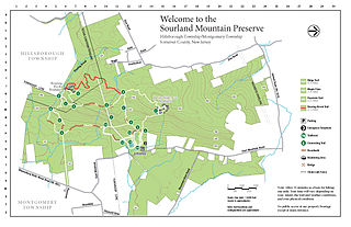
The Sourland Mountain Preserve is located on Sourland Mountain, in the Sourlands region of New Jersey. It is within Hillsborough Township and Montgomery Township of Somerset County.
County Route 518 is a county highway in the U.S. state of New Jersey. The highway extends 20.58 miles (33.12 km) from Route 165 in Lambertville to Lincoln Highway in Franklin Township. It is also known as the Georgetown Franklin Turnpike.

Sourland Mountain is a 17 miles (27 km) long ridge in central New Jersey, extending from the Delaware River at Lambertville to the western end of Hillsborough Township near the community of Neshanic, through Montgomery Township and into Hopewell Township in Mercer County. It comprises the largest contiguous forest in Central Jersey, nearly 90 square miles (233 km2) in area. The highest point is only 568 feet (173 m) above sea level, but the way it rises steeply from the surrounding farmland has earned it the title of 'mountain'. The ridge itself sits within a larger area of rough terrain called The Sourlands.

Cushetunk Mountain is a ring shaped mountain in the U.S. state of New Jersey, located in Readington and Clinton Township in Hunterdon County. The Lenape Native Americans called the mountain "Cushetunk" meaning "place of hogs" after the wild hogs found there. In the 1960s, the valley at the heart of the mountain was dammed and filled with water to create Round Valley Reservoir. Today, the mountain and its accompanying lake act as a vital water supply to Central New Jersey, while at the same time providing numerous recreational opportunities to the region.
The Central Delaware Valley AVA is an American Viticultural Area located in southeastern Pennsylvania and New Jersey. The wine appellation includes 96,000 acres (38,850 ha) surrounding the Delaware River north of Philadelphia. Its southern boundary is near Titusville, New Jersey, just north of Trenton, and its northern border is near Musconetcong Mountain. A variety of Vitis vinifera and Vitis labrusca grape varieties can be grown in the area. It has a hot-summer humid continental climate (Dfa) and is in hardiness zones 6b and 7a.
The Watchung Outliers include six areas of isolated low hills and rock outcrops of volcanic and sedimentary origin in the U.S. states of New York, New Jersey, and Pennsylvania. These geologic outliers are primarily diminutive and detached remnants of the Triassic/Jurassic age Watchung Mountain basalt flows with intervening layers of sedimentary rock. All six of the outliers are found along the western edge of the Newark Basin, occupying small synclines adjacent to the Ramapo fault system. The outliers, from north to south, are known as: Ladentown, Union Hill, New Germantown/Oldwick, Prospect Hill, Sand Brook, and Jacksonwald.

The Amwell Valley is a small valley in Hunterdon County, New Jersey, between the Hunterdon Plateau and the Sourlands. It comprises Stockton, parts of Delaware Township, West Amwell, East Amwell, Flemington and Raritan Township. The region borders the Delaware River to the west and the South Branch Raritan River to the east. The entire area has elevations around two-hundred feet above sea level. US 202 is the main route running west to east through the valley. Old York Road also passes through the valley, taking a generally more southern route through Raritan and along the Sourlands at Mount Airy. Like the Hunterdon Plateau, Amwell Valley still has a large number of farms due to its sufficient climate, relatively flat land and the presence of silt-loams soils. The valley is home to Unionville Winery and Old York Cellars in Ringoes.

The Sourlands is a region in the US state of New Jersey that includes portions of Hunterdon County, Mercer County and Somerset County. It is centered on Sourland Mountain and comprises parts of Lambertville, East Amwell, West Amwell, Hillsborough, Hopewell Boro, Hopewell Township, and Montgomery. The region is flanked by the Hopewell Fault to the south and Amwell Valley to the north that runs from Mount Airy to an area just west of Flagtown and a diabase formation running from Lambertville to Mount Airy. The Sourland also include a hilly area towards the southwest called Pleasant Valley, with a number of farms. Although much of the Sourlands is not conducive to farming, Pleasant Valley and the slopes on the surrounding ridges have a number of farms. The slopes of the ridge to the north are also home to Unionville Vineyard.
Mount Rose is a narrow section of the Rocky Hill Ridge in Hopewell Township, New Jersey which is 420 feet above sea level. The ridge's western end is at The Sourlands at Hopewell-Pennington Road and its eastern end is near Province Line Road. The ridge is a diabase intrusion and unlike many of the ridges in the state, it runs from northwest to southeast. Crusher Road travels along the ridge. Pennington-Rocky Hill Road, Cherry Valley Road, Hopewell-Princeton Road and Carter Road meet at a low point along the ridge at the village of Mount Rose.

Mount Rose is an unincorporated community located within Hopewell Township, in Mercer County, New Jersey, United States, situated at the corner of Carter Road, Pennington-Rocky Hill Road, and Cherry Valley Road. It is named for a local gardener. The Mount Rose section of Rocky Hill Ridge through the community also takes its name from the gardener. Richard Stout opened the first general store in the village around 1822 and in 1830, Josiah Cook and Reuben Savidge opened a second store. The settlement was also later home to two shoe shops, a dressmaker, wheelwrights, a blacksmith, a harness shop, an agricultural implements warehouse, a post office and a steam sawmill. In its heyday the community had about 20 houses. Nathaniel Drake opened an applejack distillery in the village in the mid-19th century. He made and sold peach brandy, apple cider and apple whiskey. The Whiskey House, the office building for the distillery and the only remaining Drake building in the village, is listed on the township, state and national registers of historic places. The community's schoolhouse, a stone building east of the crossroads, was later replaced by a frame building on the southern end of the village that is a private residence today. After 1880, Mount Rose began shrinking, due to the growth of nearby Hopewell. It is planned that the Lawrence Hopewell Trail will go through the community.

Stony Brook Branch is a tributary of the Stony Brook in Mercer County, New Jersey in the United States.

Centerville is an unincorporated community located within Hopewell Township in Mercer County, New Jersey, United States. The community is located at the intersection of Pennington-Rocky Hill Road and Titus Mill Road. Bristol-Myers Squibb's Hopewell Campus is located in Centerville.

Ackors Corner is an unincorporated community located within Hopewell Township in Mercer County, New Jersey, United States. The settlement is located at the intersection of Bear Tavern Road / Trenton-Harbourton Road, Pennington-Harbourton Road and Pleasant Valley Road. It is named for the Ackors family which owned land near the current intersection. Small residences and farmland make up the area surrounding Ackors Corner but the area rises in elevation from east to west as one approaches Baldpate Mountain, part of the Sourland Mountain range.

Glenmoore is an unincorporated community located within Hopewell Township in Mercer County, New Jersey, United States. Single-family homes make up most of the land in the area though two golf courses, the Hopewell Valley Golf Club and the Stonybrook Golf Club, are located in Glenmoore. The settlement is centered about the intersection of Pennington-Hopewell Road and Moores Mill-Mount Rose Road.

