Hopewell Valley is a group of communities in Mercer County, New Jersey loosely affiliated through municipal service sharing agreements, all of which send their students to the Hopewell Valley Regional School District.

Titusville is an unincorporated community located within Hopewell Township in Mercer County, New Jersey, United States. The area includes a post office with its own ZIP code (08560), a small village of homes, and a large park dedicated to George Washington's crossing of the Delaware River in 1776. Titusville was added to the National Register of Historic Places in 1983.

Stony Brook, also known as Stoney Brook, is a tributary of the Millstone River in Hunterdon and Mercer counties, New Jersey, in the United States.
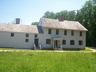
Rockingham is a historic house that was the home of John Berrien (1711–1772) and George Washington's final headquarters of the Revolutionary War. It is located at 84 Laurel Avenue, Franklin Township in Somerset County, New Jersey. The house was originally located on the hillside east of the Millstone River at Rocky Hill. It has been moved within southern Franklin Township several times, and is now closer to Kingston than to Rocky Hill. The residence is a featured part of the Millstone River Valley Scenic Byway. The oldest portion of the house was built as a two-room, two-story saltbox style house c. 1710; a kitchen and additional rooms were added on in the early 1760s, expanding with the Berrien family. The first reference to the house as "Rockingham" does not appear until a 1783 newspaper advertisement to sell the house, a name given most likely in honor of the Marquess of Rockingham.

Sourland Mountain is a 17 miles (27 km) long ridge in central New Jersey, extending from the Delaware River at Lambertville to the western end of Hillsborough Township near the community of Neshanic, through Montgomery Township and into Hopewell Township in Mercer County. It comprises the largest contiguous forest in Central Jersey, nearly 90 square miles (233 km2) in area. The highest point is only 568 feet (173 m) above sea level, but the way it rises steeply from the surrounding farmland has earned it the title of 'mountain'. The ridge itself sits within a larger area of rough terrain called The Sourlands.
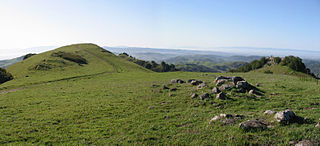
Las Trampas Regional Wilderness is a 5,342-acre (21.62 km2) regional park located in Alameda and Contra Costa counties in Northern California. The nearest city is Danville, California Las Trampas is Spanish for the traps, or the snares. The park belongs to the East Bay Regional Park District (EBRPD).
Rocky Mountain is a peak of the Blue Ridge Mountains in Virginia. It is located about 2 miles (3.5 km) east of Irish Gap, on the border of Rockbridge County and Amherst County; it is the highest point of both counties. Rocky Mountain is flanked to the northeast by Elk Pond Mountain, to the southwest by Grapevine Ridge, and to the south by Tar Jacket Ridge.
The Central Delaware Valley AVA is an American Viticultural Area located in southeastern Pennsylvania and New Jersey. The wine appellation includes 96,000 acres (38,850 ha) surrounding the Delaware River north of Philadelphia. Its southern boundary is near Titusville, New Jersey, just north of Trenton, and its northern border is near Musconetcong Mountain. A variety of Vitis vinifera and Vitis labrusca grape varieties can be grown in the area. It has a hot-summer humid continental climate (Dfa) and is in hardiness zones 6b and 7a.
Curries Woods is a neighborhood in the southern part of Greenville in Jersey City, New Jersey bordering Bayonne. It was named after James Curie, who was on the town Committee for Greenville when it was its own Township in the 19th century. The area remained rural until the later part of the century when the Central Railroad of New Jersey built a line connecting ferries to Elizabeth, New Jersey and New York City. Currie's Woods still remained untouched through the late part of the century and it was valued for its woods, rocky shore and dunes on Newark Bay. A lot of the land was eventually lost, but a tract was set aside in the early part of the 20th century. A small cemetery, the Old Greenville Cemetery, was nearby. This park lost much of its land to the city's largest Housing Authority project in 1959, except a small tract in Bayonne, Mercer Park.

The Amwell Valley is a small valley in Hunterdon County, New Jersey, between the Hunterdon Plateau and the Sourlands. It comprises Stockton, parts of Delaware Township, West Amwell, East Amwell, Flemington and Raritan Township. The region borders the Delaware River to the west and the South Branch Raritan River to the east. The entire area has elevations around two-hundred feet above sea level. US 202 is the main route running west to east through the valley. Old York Road also passes through the valley, taking a generally more southern route through Raritan and along the Sourlands at Mount Airy. Like the Hunterdon Plateau, Amwell Valley still has a large number of farms due to its sufficient climate, relatively flat land and the presence of silt-loams soils. The valley is home to Unionville Winery and Old York Cellars in Ringoes.

The Sourlands is a region in the US state of New Jersey that includes portions of Hunterdon County, Mercer County and Somerset County. It is centered on Sourland Mountain and comprises parts of Lambertville, East Amwell, West Amwell, Hillsborough, Hopewell Boro, Hopewell Township, Montgomery. The region is flanked by the Hopewell Fault to the south and Amwell Valley to the north that runs from Mount Airy to an area just west of Flagtown and a diabase formation running from Lambertville to Mount Airy. The Sourland also include a hilly area towards the southwest called Pleasant Valley, with a number of farms. Although much of the Sourlands is not conducive to farming, Pleasant Valley and the slopes on the surrounding ridges have a number of farms. The slopes of the ridge to the north are also home to Unionville Vineyard.

Mount Rose is an unincorporated community located within Hopewell Township, in Mercer County, New Jersey, United States, situated at the corner of Carter Road, Pennington-Rocky Hill Road, and Cherry Valley Road. It is named for a local gardener. The Mount Rose section of Rocky Hill Ridge through the community also takes its name from the gardener. Richard Stout opened the first general store in the village around 1822 and in 1830, Josiah Cook and Reuben Savidge opened a second store. The settlement was also later home to two shoe shops, a dressmaker, wheelwrights, a blacksmith, a harness shop, an agricultural implements warehouse, a post office and a steam sawmill. In its heyday the community had about 20 houses. Nathaniel Drake opened an applejack distillery in the village in the mid-19th century. He made and sold peach brandy, apple cider and apple whiskey. The Whiskey House, the office building for the distillery and the only remaining Drake building in the village, is listed on the township, state and national registers of historic places. The community's schoolhouse, a stone building east of the crossroads, was later replaced by a frame building on the southern end of the village that is a private residence today. After 1880, Mount Rose began shrinking, due to the growth of nearby Hopewell. It is planned that the Lawrence Hopewell Trail will go through the community.

Honey Branch is a tributary of the Stony Brook in Mercer County, New Jersey in the United States.

Stony Brook Branch is a tributary of the Stony Brook in Mercer County, New Jersey in the United States.
Woodsville Brook is a tributary of the Stony Brook in Mercer County, New Jersey in the United States.

Hopewell Valley Vineyards is a winery in Hopewell Township in Mercer County, New Jersey. The vineyard was first planted in 2001, and opened to the public in 2003. Hopewell Valley has 25 acres of grapes under cultivation, and produces 6,000 cases of wine per year. The winery is named for the region where it is located.

Centerville is an unincorporated community located within Hopewell Township in Mercer County, New Jersey, United States. The community is located at the intersection of Pennington-Rocky Hill Road and Titus Mill Road. Bristol-Myers Squibb's Hopewell Campus is located in Centerville.

The Mount Tammany Fire Road is an unpaved 4.5-mile (7.2 km) road on the eastern ridgeline of Kittatinny Mountain from Upper Yards Creek Reservoir to Mount Tammany, the 1,527-foot (465 m) prominence on the New Jersey side of the Delaware Water Gap. The fire road, located within Worthington State Forest, is maintained as a firebreak and access road for wildfire suppression efforts by the New Jersey Forest Fire Service. There are three helispots along the fire road used by the Forest Fire Service.

