The Gateway Region is the primary urbanized area of the northeastern section of the U.S. state of New Jersey. The region is anchored by Newark, the state's most populous city, and constitutes part of the New York metropolitan area.
The area encompasses Bergen, Essex, Hudson, Passaic, Union, and Middlesex counties. It is the most urban part of the state, with a population of more than four million, and is home to most of its larger cities, though much housing was originally developed as suburbs of neighboring New York City.[1][2][3][4] It is home to Ellis Island, the "gateway" through which many immigrants entered the United States, many of whom chose to stay in the region, which continues to be the port of entry and first home to many born abroad, making it one of the most ethnically diverse of the nation. It may also be the most socio-economically diverse, with some of the biggest pockets of poverty and most exclusive of suburbs in the state.[5]
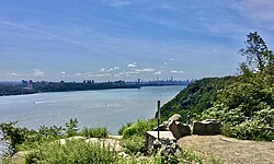
The Gateway Region is home to six of New Jersey's largest municipalities: Newark, Jersey City, Paterson, Elizabeth, Woodbridge Township, and Edison. Major rivers and the bays include the Hudson River/Upper New York Bay, the Hackensack River and the Passaic River/Newark Bay, and the Raritan. The topography of the area is quite varied, with the Palisades and the Meadowlands in the northeast, the hills and valleys of the Watchung Mountains in the west, the Ramapo Mountains in the north, and tidal plains of the Raritan to the south. The confluence of the roads and railways of the Northeast Megalopolis make the region very heavily traveled. Chemical Coast is a nickname for the heavily industrial area along the Arthur Kill. Though there are broad distinctions between cities, suburbs, heavy industry, light manufacturing, recreational "green spaces", nature preserves, and retail, transportation, and maritime infrastructure, the landscape is characterized by their close proximity to each other, as is typical of urban sprawl.
History
Lenape and New Netherland
The Gateway Region was the territory of the LenapeNative Americans. Later called Delaware Indian, this collection of Algonquian-language speaking people included the Hackensack, Raritan, and Tappan. They are recalled in the countless number of place names given by them to towns, hills, and bodies of water. Much of the land was "purchased" by Dutch and English from the Lenape, though this concept of "ownership" was foreign to them. The Lenape retreated to the west as settlements grew, and "agreed" to re-locate in 1766 with the Treaty of Easton, though some became part of the Ramapough Mountain Indians.
Henry Hudson, an Englishman sailing for the Dutch East India Company anchored his ship the Halve Maen (Half Moon) at Sandy Hook and Weehawken Cove in 1609. The area became part of the colonial province of New Netherland with headquarters in New Amsterdam. In 1630 the patroonship Pavonia was established and 1660, after series of confrontations with the Lenape, that the first chartered village was established on the west bank of the North River at Bergen Square, creating the oldest municipality in the state. Descendants of the New Netherlanders spread across North Jersey, and influenced its development and character for generations.[7]
When the English entered New York Harbor in 1664, a negotiated surrender (which guaranteed religious tolerance and protection of private property) was made to transfer control of the area to the British crown. Elizabethtown was founded as the capitol and became the first officially English-speaking settlement, named after the wife of the province's proprietor, Sir George Cateret. In 1666, Newark was established by Puritans from Connecticut. By 1675, the region become the proprietary colony of East Jersey (establishing a border with New York State, which was formalized in 1738). It was partitioned into four counties for administrative purposes: Bergen County, Essex County, Middlesex County and Monmouth County. Settlement remained sparse, though some towns were created within farming communities and along rivers and bays. Among them are Perth Amboy in 1684, Hackensack and Piscataway[8] in 1693, and New Brunswick in 1736 (which later became home to Rutgers University). During the 18th century, migration inland increased along the Horseneck Tract and Raritan Valley. Slavery and indenture were encouraged to populate the area. The third public reading of The Declaration of Independence took place in New Brunswick, but many East Jerseyans became Tories. Several battles of American Revolution took place in the region including those at Connecticut Farms, Bound Brook, and Paulus Hook.
Invention, industry and immigration
Ellis Island was the first stop for most immigrants from EuropeThe Thomas Edison factory in West Orange
The first steam engine in America was introduced at the Schuyler Copper Mine on New Barbadoes Neck in 1755.[9] In 1791, Alexander Hamilton help found the Society for the Establishment of Useful Manufactures (S.U.M.), which encouraged the harnessing of the water power of the Great Falls of the Passaic and to secure economic independence from British manufacturers. Paterson, which was founded by the society, became the cradle of the industrial revolution in America, supported in part by the Morris Canal built in the 1820s. A century later Thomas Edison, the Wizard of Menlo Park, made his mark.[10] In 1872 the Singer Manufacturing Company of New York opened a factory in Elizabethport along Trumbull Street next to the intersection of the CNJ mainline with the Perth Amboy and Elizabethport Branch.[11] Many discoveries and inventions, or application or mass production of them, were made in the Gateway Region including the steam engine, the revolver, the incandescent light bulb, the phonograph, the rocket engine, and the electric railway. It is the site of the first automobile and first submarine in the United States. It can claim to the birthplace of baseball and the American film industry, Television to the home was first broadcast in the Gateway.[12]
The Bayway Refinery, which started in 1907, is the nation's northernmost and is along the corridor with other heavy industry. It was at this time that the Chemical Coast began to be developed. The Paterson Silk Strike took place in 1913. The Hudson Waterfront became home to heavy industry and shipping. Among the industries that would prosper in the first half of the 20th century were Alcoa Aluminum, the Ford Motor Company, Lever Brothers, Valvoline Oil Co. and Archer-Daniels-Midland.[15]
While immigration to Ellis Island decreased the population continued to grow, in part due to the Great Migration. Upon entry into World War I, the US government took the Hamburg-American Line piers in Hoboken under eminent domain, which became the major point of embarkation for more than three million soldiers, known as "doughboys". Camp Merritt was established in Cresskill for troop staging.[16] In 1916, an act of sabotage literally and figuratively shook the region when German agents set off bombs at the munitions depot in New York Bay at Black Tom.[17] Another act of sabotage known as the Kingsland explosion occurred on January 11, 1917.[18] The T. A. Gillespie Company Shell Loading Plant explosion, though not considered sabotage, also caused tremendous damage.
The Gateway Region has an extensive network of national highways, state freeways, and toll roads; commuter and long-distance trains; an expanding light rail system; local and interstate bus routes; and is home to one of the New York/New Jersey metropolitan area's three major airports. Much of the rail and surface transit system is operated by New Jersey Transit and the high transit ridership is mostly oriented to commuters traveling to downtown Newark, lower and midtown Manhattan, and increasingly, the Hudson Waterfront. Outside of the most "city-like" areas of Greater Newark, Elizabeth, Hudson County, and Greater Paterson, the automobile remains the most common means of intra-regional travel.[29] The Port of New York and New Jersey is the busiest on the East Coast of the United States.
Many communities have weekly local newspapers specific to their towns, while other daily newspapers have a broader readership and are commonly available in retail shops and for delivery. The following newspapers are daily newspapers serving the Gateway Region market.
The region has ethnic market stations as well as commercial stations that mainly address the metropolitan New York City market as a whole. The WNJN network for New Jersey PBS affiliate stations provide New Jersey-specific news coverage.
Located near New York City, many residents and visitors take advantage of and contribute to performances in music, theater, and dance. There are many theater and dance companies throughout the region. Major companies, events, and performance venues include:
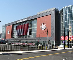
Prudential CenterThe New Jersey Performing Arts CenterKasser Theater
↑ Voorhees, David William (2009). "The Dutch Legacy in America". Dutch New York:The Roots of Hudson Valley Culture. Yonkers, New York: Fordham University Press, with Hudson River Museum. ISBN978-0-8232-3039-6.
↑ 1951: First Direct-Dial Transcontinental Telephone Call, AT&T. Accessed June 8, 2007. "Nov. 10, 1951: Mayor M. Leslie Downing of Englewood, N.J., picked up a telephone and dialed 10 digits. Eighteen seconds later, he reached Mayor Frank Osborne in Alameda, Calif. The mayors made history as they chatted in the first customer-dialed long-distance call, one that introduced area codes." "AT&T Labs Research | AT&T". Archived from the original on June 20, 2007. Retrieved 2016-08-28.
↑ Karsian, Dillon. "Garden State Plaza Reshaped Landscape."[permanent dead link], Shopping Center World, May 1, 1999. Accessed October 20, 2007. "Having undergone periodic renovations and expansions since its spring 1957 debut as an open-air center, the property today stands in the superregional class." [dead link]
This page is based on this Wikipedia article Text is available under the CC BY-SA 4.0 license; additional terms may apply. Images, videos and audio are available under their respective licenses.