
Hudson County is a densely populated county in the U.S. state of New Jersey. It lies west of the lower Hudson River, which was named for Henry Hudson, the sea captain who explored the area in 1609. Part of New Jersey's Gateway Region in the New York metropolitan area, the county's county seat and largest city is Jersey City, whose population as of the 2020 U.S. Census was 292,449.

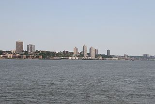
North Bergen is a township in the northern part of Hudson County, New Jersey, United States. As of the 2020 United States Census, the township had a total population of 63,361. The town was founded in 1843. It was much diminished in territory by a series of secessions. Situated on the Hudson Palisades, it is one of the "hilliest" municipalities in the United States. Like neighboring North Hudson communities, North Bergen is among those places in the nation with the highest population density and a majority Hispanic population.
A Schützenverein is a local voluntary association found in German-speaking countries revolving around shooting as a sport, often target shooting to Olympic rules or with historic weapons. Although originating as a town militia, a Schützenverein has no military aspects and in many cases often has a more social than sporting purpose.

Greenville is the southernmost section of Jersey City in Hudson County, New Jersey, United States.
Paterson Plank Road is a road that runs through Passaic, Bergen and Hudson Counties in northeastern New Jersey. The route, originally laid in the colonial era, connects the city of Paterson and the Hudson River waterfront. It has largely been superseded by Route 3, but in the many towns it passes it has remained an important local thoroughfare, and in some cases been renamed.

The Hackensack Plank Road, also known as Bergen Turnpike, was a major artery which connected the cities of Hoboken and Hackensack, New Jersey. Like its cousin routes, the Newark Plank Road and Paterson Plank Road, it travelled over Bergen Hill and across the Hackensack Meadows from the Hudson River waterfront to the city for which it was named. It was originally built as a colonial turnpike road as Hackensack and Hoboken Turnpike. The route mostly still exists today, though some segments are now called the Bergen Turnpike. It was during the 19th century that plank roads were developed, often by private companies which charged a toll. As the name suggests, wooden boards were laid on a roadbed in order to prevent horse-drawn carriages and wagons from sinking into softer ground on the portions of the road that passed through wetlands. The company that built the road received its charter on November 30, 1802. The road followed the route road from Hackensack to Communipaw that was described in 1679 as a "fine broad wagon-road."
North Hudson is the area in the northern part of Hudson County, New Jersey, situated on the west bank of the Hudson River, mostly atop the Hudson Palisades. It comprises Weehawken, Union City, West New York, Guttenberg and North Bergen.
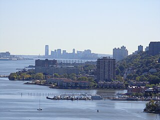
The Hudson Waterfront is an urban area of northeastern New Jersey along the lower reaches of the Hudson River, the Upper New York Bay and the Kill van Kull. Though the term can specifically mean the shoreline, it is often used to mean the contiguous urban area between the Bayonne Bridge and the George Washington Bridge that is approximately 19 miles (31 km) long. Historically, the region has been known as Bergen Neck, the lower peninsula, and Bergen Hill, lower Hudson Palisades. It has sometimes been called the Gold Coast.
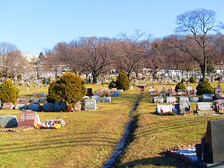
The Weehawken Cemetery, like neighboring Hoboken Cemetery, is not located in its namesake town of Weehawken but rather on the western slope of the Hudson Palisades in North Bergen, New Jersey, with its main entrance on Bergen Turnpike. At its east side the cemetery is overlooked by the Bergen Crest Mausoleum and the Garden State Crematory. and nearby Flower Hill Cemetery.
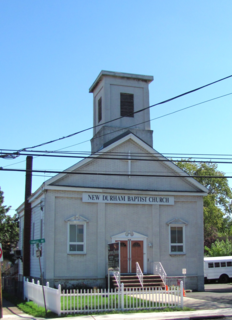
New Durham is a neighborhood in North Bergen Township in Hudson County, New Jersey, United States. It is located near the foot of Union Turnpike and Bergen Turnpike, and south of the Tonnelle Avenue Station of the Hudson Bergen Light Rail. It is one of the few residential areas along the otherwise industrial/commercial Tonnelle Ave, and site of one of the town's main post offices.

Bulls Ferry is an area along the Hudson River, just north of Weehawken Port Imperial in the towns of West New York, Guttenberg and North Bergen in New Jersey. It takes its name from a pre-Revolutionary settlement belonging to the Bull family, who operated a row-and-sail ferry to the burgeoning city of New York across the river.

County Route 617 is 4.55 miles (7.32 km) long and follows one street, Summit Avenue along the ridge of the Hudson Palisades in Hudson County, New Jersey. Its southern end is CR 622, or Grand Street, at Communipaw Junction in the Bergen-Lafayette Section of Jersey City. Its northern end is CR 691, 32nd Street, a section of the Bergen Turnpike, in Union City.

Boulevard East is a two-way, mostly two lane, scenic county road in the North Hudson, New Jersey municipalities of Weehawken, West New York, Guttenberg and North Bergen. Apart from small sections at either end, the road runs along the crest of the Hudson Palisades, affording it views of the Hudson River and the New York City skyline. Developed at the turn of the 20th century, the residential road is characterized by an eclectic mix of 20th-century architecture, including private homes as well as mid and high-rise apartment buildings, mostly on its western side, with a promenade and parks along its eastern side. It is also the setting for Edward Hopper's 1934 painting East Wind Over Weehawken, which is considered one of his best works.

The North Hudson Railway Company built and operated a streetcar system in Hudson County and southeast Bergen County, New Jersey before and after the start of the 20th century. It was founded by Hillric J. Bonn who became the first President in 1865 and served for 26 years until his death, and eventually taken over by the Public Service Railway. In its endeavors to overcome the formidable obstacle of ascending the lower Hudson Palisades, or Bergen Hill, it devised numerous innovative engineering solutions including funicular wagon lifts, an inclined elevated railway, an elevator and viaducts.

Palisade Avenue is the name given to a historic road which parallels the eastern crest of Hudson Palisades in northeastern New Jersey. It travels between Jersey City and Fort Lee, passing through Jersey City Heights, North Hudson, and Cliffside Park, with various parts carrying Hudson and Bergen county route designations. The avenue re-aligns itself at several places along its route as it crosses traditional municipal boundaries created in the 19th century. As a primary route running along the top of the Hudson Palisades, many segments offer scenic views of the Hudson River and the New York skyline.

Bergen Crest Mausoleum is a mausoleum in Hudson County, New Jersey.

North Bergen was a railroad station in North Bergen, New Jersey, United States known Homestead for most of its existence. It as built in the mid 19th century and served by the New York, Susquehanna and Western Railway (#1059) and the Erie Railroad's Northern Branch (#1903).


