Grove Church Cemetery

Last updated
Grove Church Cemetery
Grove Church Cemetery Gate.jpg
Gate entrance along Kennedy Boulevard
Grove Church Cemetery
Details
Established1847
Location
Country United States
Coordinates 40°46′59″N74°01′34″W / 40.7831566°N 74.0259734°W / 40.7831566; -74.0259734
TypeNonsectarian
Owned byReformed Grove Church
Size8 acres (3.2 ha)
Website www.grovereformedchurch.org
Find a Grave Grove Church Cemetery

The Grove Church Cemetery is a nonsectarian cemetery, [1] located on the western slope of the Hudson Palisades, along with several other cemeteries in a string of green open space, in Hudson County, New Jersey, [2] United States. The Grove Church, who owns the cemetery, is one of the oldest religious bodies in the area, and it has had an operating cemetery since 1847. Throughout its history, prominent families have been buried there, as well as American Civil war veterans. There have also been reports of vandalism and misuse of the property since the 19th century, and in 2007 some of the cemetery grounds were occupied by the homeless.

Contents

Location

Map of cemetery in 1873. GroveChurchMap.png
Map of cemetery in 1873.

Grove Church Cemetery is located at 1132 46th Street in North Bergen, New Jersey. The cemetery also fronts Kennedy Boulevard which in the 19th century was known as Dallytown Road, [3] or Bergenwood Road. [4] [5] Overlooking into the Secaucus, it starts at the top and extends onto the middle of the western face of the Hudson Palisades. Grove Church Cemetery is one of several burial sites on the western slope, along with Machpelah Cemetery, Hoboken Cemetery and Weehawken Cemetery, [6] which is only a few blocks away from Grove Church along with Palisades Cemetery. These grounds constitute a string of green open spaces in North Hudson County. [7] The gated entrance is across the street, east of the Bergenline Avenue station of the Hudson Bergen Light Rail in Union City, New Jersey.

Grove Church Cemetery is located at the western slope of the Palisades. Cemeteries In North Bergen.png
Grove Church Cemetery is located at the western slope of the Palisades.

History

Located in then both Union Hill [1] and New Durham, [8] the Reformed Church at New Durham which was also known as the "Grove Church", [3] was for many years the only Dutch Reformed church in the area. [4] It has been operational since April 12, 1843, [3] and was one of the first religious bodies established in the wilds of North Hudson, [4] the Bergen Woods. The first pastor was Reverend Philip Duryee who acted until 1844, [3] and was succeeded by William Taylor, a Rutgers graduate who later acted as pastor for a nearby Jersey City congregation. [9] Taylor was succeeded by William Mabon in 1846. [3] The land at the cemetery has been used for burial purposes since 1847, [6] which has made it one of the oldest burial grounds in Hudson County. [4] Typical grave depths are approximately five feet, and the grounds bare dry soils of yellowish earth, loose drift gravel, and pockets of sand, as well as occurrences of trap rock. [6] Before the turn of the 20th century, there were two vaults on the premises, one made of brick and the other of stone; [6] there are many more now. Overall, the grounds at Grove Church Cemetery are roughly 8 acres (3.2 ha). [10] Because of the natural descent of the cemeteries location on the western side of the Palisades, ground water flows into the surrounding marshes in Secaucus, and contamination of wells, springs, and water-courses in the surrounding area is very low. [6] Other than having a relatively large congregation, many of the church members were of wealth, and owned plots and vaults in the cemetery. [4]

In the year 1890, Edwin B. Young, a descendant of United Empire Royalists and a colonel in the King's Royal, was made superintendent of the grounds. [11] A particular wealthy family, the Gardners, had large granite vaults built very visibly to pedestrians along then Bergenwood Road. It was reported by the New York Sun that grave robbers had broken into various vaults at Grove Church. The Gardner vault had been found opened, which required the vandal to smash locks as well as break the iron railing, which was believed to be achieved by the use of hammers and chisels stolen from on adjoined marble yard. Robert Gardner's metallic coffin was found opened, removed from the shelf upon which it sat. The investigation, led by Superintendent Young, left those involved unsure of why the perpetrators would have broken in, and with no apparent objective or reason, they concluded that it may have been done simply to desecrate the resting place of the dead. [4] Young held that position of superintendent until 1899, for the pursuit of real estate. [11]

It is owned and maintained by the Reformed Grove Church, and is still active and well kept, [2] and the offices are located on the cemetery grounds. There are 31 American Civil War veteran graves at Grove Church Cemetery. [12]

Use by the homeless

Cemetery along southern perimeter. GroveChurchCemetery.jpg
Cemetery along southern perimeter.

Called "a cemetery for the living", [13] it was reported in 2007 that between 30 and 135 homeless people were squatting in the Grove Church Cemetery. An investigation had been brought on by a sexual assault of a woman, who was near the Bergenline Avenue Station of the Hudson Bergen Light Rail, and by knife-point was brought into the cemetery and assaulted. [14] Upon searching the grounds, police found remnants of living activity, namely mattresses, pillows, and blankets, as well as garbage strewn across the lawn. [15] Also, small shacks had been built along the perimeter. To the dismay of neighbors, who had complained about the noise and feeling unsafe, there was not much that the police could do to remove the people off of the premises; there is no law against loitering in public places. One victim, however, claimed that there were bronze urns stolen from his relative's tomb. [13] In addition, the Reformed Grove Church had been supporting the homeless by providing them with meals, as it is within their rights and devotion to charity that they will not turn away anyone seeking help. [14]

The homeless, who were by majority South and Central American males, said that they came into the area from their respective countries in promise of work. A particular individual who was interviewed said that the work he was told about had only been short term and, along with many of the others, had nowhere else to go. [14] Most who had been approached about relocation into nearby homeless shelters express their hesitation to leave the Grove Church Cemetery grounds, fearful that they would lose the freedom they had on the public property. Measures were taken to remove and clean up the cemetery, and it is believed that while some may have entered into shelters, others likely still reside in the general area, while some had moved into the wooded eastern side of the Palisades hills in Union City, [15] where many shacks can be seen supporting the homeless.

Notable burials

See also

Related Research Articles

<span class="mw-page-title-main">North Bergen, New Jersey</span> Township in Hudson County, New Jersey, United States

North Bergen is a township in the northern part of Hudson County, in the U.S. state of New Jersey. As of the 2020 United States census, the township's population was 63,361, an increase of 2,588 (+4.3%) from the 2010 census count of 60,773, which in turn reflected an increase of 2,681 (+4.6%) from the 58,092 counted in the 2000 census. The township was incorporated in 1843. It was much diminished in territory by a series of secessions. Situated on the Hudson Palisades, it is one of the hilliest municipalities in the United States. Like neighboring North Hudson communities, North Bergen is among those places in the nation with the highest population density and a majority Hispanic population.

<span class="mw-page-title-main">Union City, New Jersey</span> City in Hudson County, New Jersey, United States

Union City is a city in the northern part of Hudson County, in the U.S. state of New Jersey. As of the 2020 United States census, the city was the state's 18th-most-populous municipality, with a population of 68,589, an increase of 2,134 (+3.2%) from the 2010 census count of 66,455, which in turn had reflected a decline of 633 (−0.9%) from the 67,088 counted in the 2000 census. As of the 2010 Census, among cities with a population of more than 50,000, it was the most densely populated city in the United States, with a density of 54,138 per square mile of land. The Census Bureau's Population Estimates Program calculated that the city's population was 65,366 in 2022, ranking the city the 590th-most-populous in the country.

<span class="mw-page-title-main">Flower Hill Cemetery (North Bergen, New Jersey)</span>

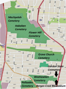
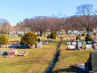
Flower Hill Cemetery is located in North Bergen, New Jersey. It is cojoined with Hoboken Cemetery and Machpelah Cemetery.

<span class="mw-page-title-main">Bergenline Avenue station</span>

Bergenline Avenue is a station on the Hudson–Bergen Light Rail (HBLR). The intermodal facility is located on 49th Street between Bergenline Avenue and Kennedy Boulevard in Union City, New Jersey, near its border with West New York and North Bergen. The station is the first and only completely underground station on the network and opened for service on February 25, 2006.

<span class="mw-page-title-main">Hackensack Plank Road</span>

The Hackensack Plank Road, also known as Bergen Turnpike, was a major artery which connected the cities of Hoboken and Hackensack, New Jersey. Like its cousin routes, the Newark Plank Road and Paterson Plank Road, it travelled over Bergen Hill and across the Hackensack Meadows from the Hudson River waterfront to the city for which it was named. It was originally built as a colonial turnpike road as Hackensack and Hoboken Turnpike. The route mostly still exists today, though some segments are now called the Bergen Turnpike. It was during the 19th century that plank roads were developed, often by private companies which charged a toll. As the name suggests, wooden boards were laid on a roadbed in order to prevent horse-drawn carriages and wagons from sinking into softer ground on the portions of the road that passed through wetlands. The company that built the road received its charter on November 30, 1802. The road followed the route road from Hackensack to Communipaw that was described in 1679 as a "fine broad wagon-road."

<span class="mw-page-title-main">Bergenline Avenue</span> Street in Hudson County, New Jersey, US

Bergenline Avenue is a major commercial district in the North Hudson section of Hudson County, New Jersey, United States. The north–south streets passes through Union City, West New York, Guttenberg, and North Bergen. Its southern end is at Union City's Second Street, the north boundary of Washington Park. From there north to 47th Street, the street is one-way southbound; New York Avenue and Kennedy Boulevard serve northbound traffic. Between 48th and 49th Streets, elevators on the west side provide access to the underground Bergenline Avenue station of the Hudson-Bergen Light Rail. After passing through West New York and Guttenberg and into North Bergen, the street meets North Hudson Park, running along its west side from 79th Street to the Bergen County line through the community of Nungesser's and crosses Kennedy Boulevard. The northernmost 0.04 miles (0.064 km) of the route from Kennedy Boulevard to the Bergen County line is designated as County Route 721. North of the county line the street name becomes Anderson Avenue, which is the major commercial district for Fairview, Cliffside Park, and Fort Lee.

<span class="mw-page-title-main">Union Hill, New Jersey</span> Place in New Jersey, United States

Union Hill was a town that existed in Hudson County, New Jersey, United States, from 1864 to June 1, 1925, when it merged with West Hoboken to form Union City.

<span class="mw-page-title-main">Old Bergen Church</span> Historic church in New Jersey, United States

The Old Bergen Church is a historic church congregation in Jersey City, Hudson County, New Jersey, United States. Established in 1660 in what was then the Dutch colony of New Netherland, it is the oldest continuous religious congregation in what is today the State of New Jersey. The congregation is jointly affiliated with the Reformed Church in America and the Presbyterian Church (USA). The church was added to the National Register of Historic Places on August 14, 1973. The original church building was constructed in 1680 and the current edifice was built in 1841.

<span class="mw-page-title-main">Weehawken Cemetery</span> Cemetery in New Jersey, U.S.

The Weehawken Cemetery, like neighboring Hoboken Cemetery, is not located in its namesake town of Weehawken but rather on the western slope of the Hudson Palisades in North Bergen, New Jersey, with its main entrance on Bergen Turnpike. At its east side the cemetery is overlooked by the Bergen Crest Mausoleum and the Garden State Crematory. and nearby Flower Hill Cemetery.

<span class="mw-page-title-main">Schuetzen Park (New Jersey)</span> Private park in Hudson County, New Jersey, US

Schuetzen Park is a privately owned park in North Bergen, New Jersey, United States, that has existed since 1872 and is located on the ridge of the Hudson Palisades at Kennedy Boulevard and Bergen Turnpike just north of the Marginal Highway. Its southern and western perimeters are shared with the Fritz Reuter Altenheim, a retirement community named for the German author, Fritz Reuter, and Columbia Park, a large shopping center. The German-American Volksfest has taken place there annually since its construction.

<span class="mw-page-title-main">New Durham, North Bergen</span> Populated place in Hudson County, New Jersey, US

New Durham is a neighborhood in North Bergen Township in Hudson County, in the U.S. state of New Jersey. It is located near the foot of Union Turnpike and Bergen Turnpike, and south of the Tonnelle Avenue Station of the Hudson Bergen Light Rail. It is one of the few residential areas along the otherwise industrial/commercial Tonnelle Ave, and site of one of the town's main post offices.

<span class="mw-page-title-main">Bergenwood, North Bergen</span> Populated place in Hudson County, New Jersey, US

Bergenwood is a long narrow district of North Bergen, New Jersey in the northern central part of the township between Kennedy Boulevard and Tonnelle Avenue, characterized by the steep slopes on the west side of the Hudson Palisades as they descend to the New Jersey Meadowlands.

<span class="mw-page-title-main">Summit Avenue (Hudson Palisades)</span> Road in Hudson County, New Jersey, US

County Route 617 is 4.55-mile (7.32 km) long and follows one street, Summit Avenue along the ridge of the Hudson Palisades in Hudson County, New Jersey. Its southern end is CR 622, or Grand Street, at Communipaw Junction in the Bergen-Lafayette Section of Jersey City. Its northern end is CR 691, 32nd Street, a section of the Bergen Turnpike, in Union City.

<span class="mw-page-title-main">Central Avenue (Hudson Palisades)</span> Populated place in Hudson County, New Jersey, US

Central Avenue is a 12-block-long thoroughfare in the Heights neighborhood of Jersey City, New Jersey, United States. One of 13 shopping districts in the city, it is designated County Route 663 for 1.60-mile (2.57 km) of its length. It originates at the intersection of Summit Avenue and Pavonia Avenue, and runs north, intersecting Newark Avenue one block east of Five Corners to Paterson Plank Road near Transfer Station. The avenue continues north through Union City without the county route designation to 35th Street, two blocks north of Hackensack Plank Road.

<span class="mw-page-title-main">Nungessers</span> Junction in Bergen and Hudson counties, New Jersey, US

Nungessers is the name of the confluence of roads that meet at the Hudson and Bergen county line at North Bergen and Fairview in northeastern New Jersey. The area is the former site of the Nungesser's Gutenberg Racetrack, a late 19th-century gaming and gambling venue. The neighborhood just south of Nungesser's is called the Racetrack Section and the municipality of Guttenberg is nearby. A White Castle, an early drive-in fast-food chain, originally built in the 1930s has long been a landmark in the neighborhood, as has adjacent North Hudson Park.

<span class="mw-page-title-main">Machpelah Cemetery (North Bergen, New Jersey)</span> Cemetery in New Jersey, US

The Machpelah Cemetery, also spelled as "Macpelah Cemetery", or "Macphelah Cemetery", is a cemetery in Hudson County, New Jersey.

<span class="mw-page-title-main">Bergen Crest Mausoleum</span> Cemetery in North Bergen, New Jersey, US

Bergen Crest Mausoleum is a mausoleum in Hudson County, New Jersey.

<span class="mw-page-title-main">Abel I. Smith Burial Ground</span>

The Abel I. Smith Burial Ground was a family burial plot in Hudson County, New Jersey, United States.

References

  1. 1 2 Brooklyn Fairchild Sons, p. 63.
  2. 1 2 "Grove Church Cemetery Hudson County, New Jersey". Interment.net: Cemetery Records Online. Clear Digital Media, Inc. 1997–2010. Retrieved September 22, 2010.
  3. 1 2 3 4 5 Winfield, p. 388.
  4. 1 2 3 4 5 6 United States Cremation Company, et al., p. 8.
  5. Inskeep, p. 228.
  6. 1 2 3 4 5 National Board of Health, p. 202.
  7. Hagstrom Map, Hudson County.
  8. Leonard, p. 40.
  9. Wilson, et al, p. 42
  10. State Dept. of Health, p. 234.
  11. 1 2 Harvey, p. 135.
  12. "Grove Church Cemetery – North Bergen". New Jersey Civil War Gravestones. 2003–2010. Retrieved 22 September 2010.
  13. 1 2 Loboguerrero, Cristina (September 3, 2007). "A cemetery for the living". Voices that must be heard. New York Community Media Alliance. Retrieved 23 September 2010.
  14. 1 2 3 Hague, Jim (September 2, 2007). "Dozens of immigrants hiding in cemetery Vagrants say they have nowhere to live besides North Bergen graveyard". Hudson Reporter . Retrieved 23 September 2010.
  15. 1 2 Hague, Jim (September 25, 2007). "Chasing them away Police conduct sweeps of vagrants living in cemetery". Hudson Reporter . Retrieved 23 September 2010.
  16. Grassby, p. 10.

Sources

Further reading