
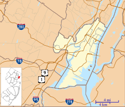
North Bergen is a township in the northern part of Hudson County, in the U.S. state of New Jersey. As of the 2020 United States census, the township's population was 63,361, an increase of 2,588 (+4.3%) from the 2010 census count of 60,773, which in turn reflected an increase of 2,681 (+4.6%) from the 58,092 counted in the 2000 census. The township was incorporated in 1843. It was much diminished in territory by a series of secessions. Situated on the Hudson Palisades, it is one of the hilliest municipalities in the United States. Like neighboring North Hudson communities, North Bergen is among those places in the nation with the highest population density.

The Northern Branch is a railroad line that runs from Jersey City to Northvale in northeastern New Jersey, and formerly extended further into New York State. The line was constructed in 1859 by the Northern Railroad of New Jersey to connect the New York and Erie Railroad's Piermont Branch terminus in Piermont, New York, directly to Erie's primary terminal in Jersey City, initially Exchange Place, later Pavonia Terminal. In 1870 the line was extended to Nyack, New York, and continued to provide passenger service until 1966. After the Erie's unsuccessful merger with the Lackawanna Railroad to form the Erie-Lackawanna, ownership of the line passed into the hands of Conrail upon its formation in 1976 from a number of bankrupt railroads.

Greenville is the southernmost section of Jersey City in Hudson County, in the U.S. state of New Jersey.
Paterson Plank Road is a road that runs through Passaic, Bergen and Hudson Counties in northeastern New Jersey. The route, originally laid in the colonial era, connects the city of Paterson and the Hudson River waterfront. It has largely been superseded by Route 3, but in the many towns it passes it has remained an important local thoroughfare, and in some cases been renamed.

The Hackensack Plank Road, also known as Bergen Turnpike, was a major artery which connected the cities of Hoboken and Hackensack, New Jersey. Like its cousin routes, the Newark Plank Road and Paterson Plank Road, it travelled over Bergen Hill and across the Hackensack Meadows from the Hudson River waterfront to the city for which it was named. It was originally built as a colonial turnpike road as Hackensack and Hoboken Turnpike. The route mostly still exists today, though some segments are now called the Bergen Turnpike. It was during the 19th century that plank roads were developed, often by private companies which charged a toll. As the name suggests, wooden boards were laid on a roadbed in order to prevent horse-drawn carriages and wagons from sinking into softer ground on the portions of the road that passed through wetlands. The company that built the road received its charter on November 30, 1802. The road followed the route road from Hackensack to Communipaw that was described in 1679 as a "fine broad wagon-road."

Bergen Hill refers to the lower Hudson Palisades in New Jersey, where they emerge on Bergen Neck, which in turn is the peninsula between the Hackensack and Hudson Rivers, and their bays. In Hudson County, it reaches a height of 260 feet.

The Passaic–Bergen–Hudson Transit Project is a project under study by NJ Transit to reintroduce passenger service on a portion of the New York, Susquehanna and Western Railway (NYSW) right-of-way (ROW) in Passaic, Bergen and Hudson counties using newly built, FRA-compliant diesel multiple unit rail cars. Plans call for service to run from Hawthorne south through Paterson, east to Hackensack and then southeast to North Bergen, where it would join the Hudson-Bergen Light Rail (HBLR).

Bergenwood is a long narrow district of North Bergen, New Jersey in the northern central part of the township between Kennedy Boulevard and Tonnelle Avenue, characterized by the steep slopes on the west side of the Hudson Palisades as they descend to the New Jersey Meadowlands.

The Jersey City and Bergen Point Plank Road was a road originally built in the 19th century in Hudson County, New Jersey, United States which ran between Paulus Hook and Bergen Point. The company that built the road received a charter on March 6, 1850 to improve one that had been built in the 18th century. It has subsequently become Grand Street and Garfield Avenue in Jersey City and Broadway in Bayonne. Plank roads were built during the 19th century, often by private companies as turnpike roads, in this case with a tollgate at Communipaw Junction. As the name suggests, wooden boards were laid on a roadbed in order to prevent horse-drawn carriages and wagons from sinking into softer ground on the portions of the road.

Maisland, or Mais Land, was an area in Hudson County, New Jersey.
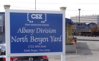
The North Bergen Yard is freight rail yard and intermodal terminal in North Bergen, New Jersey parallel to Tonnelle Avenue between 49th and 69th Streets. Located within the North Jersey Shared Assets Area, the facility is part of CSX Transportation (CSXT) and the origination point of its CSX River Subdivision at the southern end of the Albany Division. On its west side, the New York, Susquehanna and Western Railway (NYSW) runs the length of the yard and operates a bulk transloading operation immediately adjacent to it.
Babbitt is a neighborhood in North Bergen Township in Hudson County, in the U.S. state of New Jersey. The area, located west of Tonnelle Avenue within the New Jersey Meadowlands District, is home to light manufacturing, warehouses, transportation facilities, and part of the wetlands preservation area known as the Eastern Brackish Marsh.

Little Ferry Yard is a railyard and intermodal terminal in the Port of New York and New Jersey served by the CSX River Subdivision (CSXT), New York, Susquehanna and Western Railway (NYSW), Norfolk Southern Railway and Conrail Shared Assets Operations (CRCX).
91st Street is a proposed station along the Northern Branch Corridor Project extension of Hudson-Bergen Light Rail in the Babbitt Section of North Bergen, New Jersey.

Bogota was a railroad station in Bogota, New Jersey, at Court Street/Fort Lee Road west of River Road and east of the Court Street Bridge over the Hackensack River. It was located on the New York, Susquehanna and Western Railway Main Line, which provided passenger service between the 1870s and 1960s.
69th Street is a proposed interchange station in North Bergen in Hudson County, New Jersey. It would serve passengers on two lines under consideration by NJ Transit, the Passaic–Bergen–Hudson Transit Project and the Northern Branch Corridor Project, the latter of which is an extension of the Hudson–Bergen Light Rail. The station would located at-grade west the North Bergen Yard and Tonnelle Avenue.

The Vince Lombardi Park & Ride is located on the New Jersey Turnpike in the Meadowlands in Ridgefield, Bergen County, New Jersey. The park and ride and separate service area to south of it are dedicated to and named after Vince Lombardi. Located at the edge of the Little Ferry Yard it has been viewed as a potential rail station location since the 1990s and as of 2021, it is under consideration by NJ Transit as part of the Passaic–Bergen–Hudson Transit Project.

Broadway–Paterson was a New York, Susquehanna and Western Railroad (NYS&W) station in Paterson, New Jersey near the level, or at-grade crossing south of Broadway at Ellison Place and Madison Avenue. Service by the New Jersey Midland, a predecessor to the NYS&W, had begun in 1873. It was originally known as Paterson, but was renamed after a junction of the railroad's mainline was created to build the Paterson City Branch. The station house, demolished in 1982, was situated between the two lines and served as the Susquehanna's headquarters for several years. Passenger service on the branch ended in 1960 and on the mainline in 1966.

North Bergen was a railroad station in North Bergen, New Jersey, United States known Homestead for most of its existence. It as built in the mid 19th century and served by the New York, Susquehanna and Western Railway (#1059) and the Erie Railroad's Northern Branch (#1903).

