
Maisland, or Mais Land, was an area in Hudson County, New Jersey.
Maisland, or Mais Land, was an area in Hudson County, New Jersey.

The region of Maisland was located on the western slope of the Hudson Palisades. Under the governorship of Philip Carteret, land in the region of Bergen [2] was sold under the name the "New Mais Land" on May 12, 1668. [3] A Dutch settler named Caspar Stienmets, the judge for court in Bergen, [4] purchased the town lot which amounted to nearly 100 acres (400,000 m2), which included meadowlands and woodlands. [5] The official proceeding allotted the area in the statement:
... between Dunne Hermansen and Hendricke DeBracken. 2 — 17 acres of wood land and meadows next to Capt. Nicholas Verlath; 3 — 16 of woodland ; No. 4, Town lot next to Herman Edwartse; No. 5, One lot of Gerrit Gerritsen; No. 6, A town lot, 100 acres in all.
The township of Bergen was divided into several road districts by the freeholders of the Bergen, with the purpose to better regulate the local highway systems. [6] What arose from the annual meeting was the creation of several districts, which remain today somewhat as distinct neighborhoods or cities; some of which were Bergen Woods, Bulls Ferry, Sekakes and Wehauk along with Maisland, [7] and upon the freeholders' decision, an overseer for each district was appointed. [6]
The area, which was one of the most populous sections of the township of Bergen, [8] was referred to as Maisland for 135 years, [9] when in the year 1803, Maisland became known as New Durham, which later on became part of North Bergen, New Jersey. [10] Maisland today constitutes the same area as New Durham did, which is bounded roughly by the beginning of Union Turnpike, Bergen Turnpike, and the Tonnelle Avenue Station of the Hudson Bergen Light Rail. [11] Within its vicinity during Maisland's frame of time was the Three Pigeons Tavern, [12] which stood at the southern fringe of Maisland near the intersection of Tonnelle Avenue and Hackensack Plank Road, [13] and the "Frenchman's Garden". This garden in Maisland, which later became Machpelah Cemetery, [14] was the early source for Lombardy poplar Populus nigra, which spread across the United States. [8] [15]
The name Maisland comes from "Maize Land", where maize is the Native American word for corn. [16]
A trucking company "Maisland Trucking Co." operated in nearby Kearny, New Jersey. [17]
| New Netherland series |
|---|
| Exploration |
| Fortifications: |
| Settlements: |
| The Patroon System |
|
| People of New Netherland |
| Flushing Remonstrance |
 |

Hudson County is the smallest and most densely populated county in the U.S. state of New Jersey. It lies west of the lower Hudson River, which was named for Henry Hudson, the sea captain who explored the area in 1609. Part of New Jersey's Gateway Region in the New York metropolitan area, the county seat is Jersey City, which is the county's largest city in terms of both population and area. The county is part of the North Jersey region of the state.

North Bergen is a township in the northern part of Hudson County, in the U.S. state of New Jersey. As of the 2020 United States census, the township's population was 63,361, an increase of 2,588 (+4.3%) from the 2010 census count of 60,773, which in turn reflected an increase of 2,681 (+4.6%) from the 58,092 counted in the 2000 census. The township was incorporated in 1843. It was much diminished in territory by a series of secessions. Situated on the Hudson Palisades, it is one of the hilliest municipalities in the United States. Like neighboring North Hudson communities, North Bergen is among those places in the nation with the highest population density.
Boroughitis was the creation in the 1890s, usually by referendum, of large numbers of small boroughs in the U.S. state of New Jersey, particularly in Bergen County. Attempts by the New Jersey Legislature to reform local government and school systems led to the breakup of most of Bergen County's townships into small boroughs, which still balkanize the state's political map. This occurred following the development of commuter suburbs in New Jersey, residents of which wanted more government services, whereas the long-time rural population feared the increases in taxation that would result.

Greenville is the southernmost section of Jersey City in Hudson County, in the U.S. state of New Jersey.

Snake Hill is an igneous rock intrusion jutting up from the floor of the Meadowlands in southern Secaucus, New Jersey, United States, at a bend in the Hackensack River. It was largely obliterated in the 1960s by quarrying that reduced the height of some sections by one-quarter and the area of its base by four fifths. The diabase rock was used as building material in growing areas like Jersey City. The remnant of the hill is the defining feature of Laurel Hill County Park. The high point, a 203-foot graffiti-covered inselberg rock formation, is a familiar landmark to travelers on the New Jersey Turnpike's Eastern Spur, which skirts the hill's southern edge. The crest of the hill's unusual, sloping ridge is about 150 feet high.
Paterson Plank Road is a road that runs through Passaic, Bergen and Hudson Counties in northeastern New Jersey. The route, originally laid in the colonial era, connects the city of Paterson and the Hudson River waterfront. It has largely been superseded by Route 3, but in the many towns it passes it has remained an important local thoroughfare, and in some cases been renamed.

The Hackensack Plank Road, also known as Bergen Turnpike, was a major artery which connected the cities of Hoboken and Hackensack, New Jersey. Like its cousin routes, the Newark Plank Road and Paterson Plank Road, it travelled over Bergen Hill and across the Hackensack Meadows from the Hudson River waterfront to the city for which it was named. It was originally built as a colonial turnpike road as Hackensack and Hoboken Turnpike. The route mostly still exists today, though some segments are now called the Bergen Turnpike. It was during the 19th century that plank roads were developed, often by private companies which charged a toll. As the name suggests, wooden boards were laid on a roadbed in order to prevent horse-drawn carriages and wagons from sinking into softer ground on the portions of the road that passed through wetlands. The company that built the road received its charter on November 30, 1802. The road followed the route road from Hackensack to Communipaw that was described in 1679 as a "fine broad wagon-road."

West Hoboken was a municipality that existed in Hudson County, New Jersey, from 1861 to 1925. It merged with Union Hill to form Union City on June 1, 1925.
Curries Woods is a neighborhood in the southern part of Greenville in Jersey City, New Jersey bordering Bayonne. It was named after James Curie, who was on the town Committee for Greenville when it was its own Township in the 19th century. The area remained rural until the later part of the century when the Central Railroad of New Jersey built a line connecting ferries to Elizabeth, New Jersey and New York City. Currie's Woods still remained untouched through the late part of the century and it was valued for its woods, rocky shore and dunes on Newark Bay. A lot of the land was eventually lost, but a tract was set aside in the early part of the 20th century. A small cemetery, the Old Greenville Cemetery, was nearby. This park lost much of its land to the city's largest Housing Authority project in 1959, except a small tract in Bayonne, Mercer Park.
Woodcliff is a neighborhood in northeastern North Bergen, New Jersey. The center of area is a large Hudson County park known as North Hudson Park, which refers to the collective name of the municipalities in northern part of the county, and is officially named for James J. Braddock, an American boxer who was a resident the township.

New Durham is a neighborhood in North Bergen Township in Hudson County, in the U.S. state of New Jersey. It is located near the foot of Union Turnpike and Bergen Turnpike, and south of the Tonnelle Avenue Station of the Hudson Bergen Light Rail. It is one of the few residential areas along the otherwise industrial/commercial Tonnelle Ave, and site of one of the town's main post offices.

Bergenwood is a long narrow district of North Bergen, New Jersey in the northern central part of the township between Kennedy Boulevard and Tonnelle Avenue, characterized by the steep slopes on the west side of the Hudson Palisades as they descend to the New Jersey Meadowlands.

Central Avenue is a 12-block-long thoroughfare in the Heights neighborhood of Jersey City, New Jersey, United States. One of 13 shopping districts in the city, it is designated County Route 663 for 1.60-mile (2.57 km) of its length. It originates at the intersection of Summit Avenue and Pavonia Avenue, and runs north, intersecting Newark Avenue one block east of Five Corners to Paterson Plank Road near Transfer Station. The avenue continues north through Union City without the county route designation to 35th Street, two blocks north of Hackensack Plank Road.

The Grove Church Cemetery is a nonsectarian cemetery, located on the western slope of the Hudson Palisades, along with several other cemeteries in a string of green open space, in Hudson County, New Jersey, United States. The Grove Church, who owns the cemetery, is one of the oldest religious bodies in the area, and it has had an operating cemetery since 1847. Throughout its history, prominent families have been buried there, as well as American Civil war veterans. There have also been reports of vandalism and misuse of the property since the 19th century, and in 2007 some of the cemetery grounds were occupied by the homeless.

The Machpelah Cemetery, also spelled as "Macpelah Cemetery", or "Macphelah Cemetery", is a cemetery in Hudson County, New Jersey.

Bergen Crest Mausoleum is a mausoleum in Hudson County, New Jersey.

The Three Pigeons was a prominent and famous meeting place in Bergen Township, New Jersey, during the revolutionary period, and was used historically as a landmark as well as a popular place for hosting special occasions.
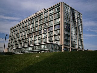
The Hudson County Administration Building is home to the seat of government of Hudson County, New Jersey, US. It is located at 595 Newark Avenue in the Journal Square section of Jersey City in the abutting Five Corners and Hilltop neighborhoods The building houses government administrative offices, the hall of records, and courts for the county and state. Opened in 1957 and expanded in 1966, the International Style structure is considered obsolete and will be replaced upon completion of the Frank J. Guarini Justice Complex.
40°47′14″N74°01′50″W / 40.78718°N 74.03065°W
Municipalities and communities of Hudson County, New Jersey, United States | ||
|---|---|---|
| Cities |  | |
| Borough | ||
| Towns | ||
| Townships | ||
| Regions | ||