Route 5 is a 3.18-mile (5.12 km) state highway located entirely in Bergen County, New Jersey, United States. It runs from U.S. Route 1/9 (US 1-9) in Ridgefield east down the New Jersey Palisades to end at County Route 505 at the Hudson River in Edgewater, forming a “wavy” path. The route is a two- to four-lane undivided highway its entire length, passing mostly through wooded residential neighborhoods. The route passes under Route 63 in Palisades Park, with access to that route provided by Bergen Boulevard, and intersects the southern terminus of Route 67 in Fort Lee.

Weehawken is a township in the northern part of Hudson County, in the U.S. state of New Jersey. It is located on the Hudson Waterfront and Hudson Palisades overlooking the Hudson River. As of the 2020 United States census, the township's population was 17,197, an increase of 4,643 (+37.0%) from the 2010 census count of 12,554, which in turn reflected a decline of 947 (−7.0%) from the 13,501 counted in the 2000 census.

The Hudson–Bergen Light Rail (HBLR) is a light rail system in Hudson County, New Jersey, United States. Owned by New Jersey Transit (NJT) and operated by the 21st Century Rail Corporation, it connects the communities of Bayonne, Jersey City, Hoboken, Weehawken, Union City, at the city line with West New York, and North Bergen.

For the purposes of this article, the Jersey City area extends North to Edgewater, South to Bayonne and includes Kearny Junction and Harrison but not Newark. Many routes east of Newark are listed here.
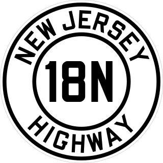
Route 18N was a state highway in New Jersey from 1923 to 1929, when it was renumbered as Route 1 and Route S1A. Route 18-N was defined in 1923 to run "from Hoboken to New York State line by way of Weehawken, West Hoboken, town of Union, North Bergen, Fairview, Ridgefield, Palisade Park, Fort Lee, Englewood-Cliffs, Tenafly and Alpine." The part from Hoboken to Fort Lee was not built or taken over as Route 18-N; it seems to follow the old Bergen Turnpike to Ridgefield and then Route 5 east. Route 18-N's south end was at pre-1927 Route 10, now Route 5.
Paterson Plank Road is a road that runs through Passaic, Bergen and Hudson Counties in northeastern New Jersey. The route, originally laid in the colonial era, connects the city of Paterson and the Hudson River waterfront. It has largely been superseded by Route 3, but in the many towns it passes it has remained an important local thoroughfare, and in some cases been renamed.
The Newark Plank Road was a major artery between Hudson Waterfront at Paulus Hook and city of Newark further inland across the New Jersey Meadows. As its name suggests, a plank road was constructed of wooden planks laid side-to-side on a roadbed. Similar roads, the Bergen Point Plank Road, the Hackensack Plank Road and Paterson Plank Road, traveled to the locales for which they are named. The name is no longer used, the route having been absorbed into other streets and freeways.
Bergen Hill refers to the lower Hudson Palisades in New Jersey, where they emerge on Bergen Neck, which in turn is the peninsula between the Hackensack and Hudson Rivers, and their bays. In Hudson County, it reaches a height of 260 feet.

Weehawken Terminal was the waterfront intermodal terminal on the North River in Weehawken, New Jersey for the New York Central Railroad's West Shore Railroad division, whose route traveled along the west shore of the Hudson River. It opened in 1884 and closed in 1959. The complex contained five ferry slips, sixteen passenger train tracks, car float facilities, and extensive yards. The facility was also used by the New York, Ontario and Western Railway. The terminal was one of five passenger railroad terminals that lined the Hudson Waterfront during the 19th and 20th centuries; the others were located at Hoboken, Pavonia, Exchange Place and Communipaw, with Hoboken being the only one still in use.
The Hudson Waterfront is an urban area of northeastern New Jersey along the lower reaches of the Hudson River, the Upper New York Bay and the Kill van Kull. Though the term can specifically mean the shoreline, it is often used to mean the contiguous urban area between the Bayonne Bridge and the George Washington Bridge that is approximately 19 miles (31 km) long. Historically, the region has been known as Bergen Neck, the lower peninsula, and Bergen Hill, lower Hudson Palisades. It has sometimes been called the Gold Coast.

New Durham is a neighborhood in North Bergen Township in Hudson County, in the U.S. state of New Jersey. It is located near the foot of Union Turnpike and Bergen Turnpike, and south of the Tonnelle Avenue Station of the Hudson Bergen Light Rail. It is one of the few residential areas along the otherwise industrial/commercial Tonnelle Ave, and site of one of the town's main post offices.

Bulls Ferry is an area along the Hudson River, just north of Weehawken Port Imperial in the towns of West New York, Guttenberg and North Bergen in New Jersey. It takes its name from a pre-Revolutionary settlement belonging to the Bull family, who operated a row-and-sail ferry to the burgeoning city of New York across the river.

Pershing Road is a road located entirely in Weehawken, New Jersey that travels for 0.42 miles (0.68 km) on the Hudson Palisades between Boulevard East and Weehawken Port Imperial, and carries the designation Hudson County Route 682. At County Route 505, the road meets 48th Street, one of the very few two-way streets in the urban grid of North Hudson, which travels west to Bergenline Avenue and Kennedy Boulevard. It is named for World War I hero John J. Pershing. Earlier names have included Clifton Road, named for the estate on whose land it was located, and Hillside Road, which would speak to its location.

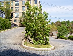
Shippen Street is an east-west street in Weehawken, New Jersey. The eastern terminal, a cobblestone double hairpin turn is listed on the New Jersey Register of Historic Places. Shippen Street was developed at the start of the 20th century as part of the Weehawken Heights, one of the town's residential neighborhoods.

Boulevard East is a two-way, mostly two lane, scenic county road in the municipalities of Weehawken, West New York, Guttenberg and North Bergen in North Hudson, New Jersey. Apart from small sections at either end, the road runs along the crest of the Hudson Palisades, affording it views of the Hudson River and the New York City skyline. Developed at the turn of the 20th century, the residential road is characterized by an eclectic mix of 20th-century architecture, including private homes as well as mid and high-rise apartment buildings, mostly on its western side, with a promenade and parks along its eastern side. It is also the setting for Edward Hopper's 1934 painting East Wind Over Weehawken, which is considered one of his best works.

The North Hudson Railway Company built and operated a streetcar system in Hudson County and southeast Bergen County, New Jersey before and after the start of the 20th century. It was founded by Hillric J. Bonn who became the first President in 1865 and served for 26 years until his death, and eventually taken over by the Public Service Railway. In its endeavors to overcome the formidable obstacle of ascending the lower Hudson Palisades, or Bergen Hill, it devised numerous innovative engineering solutions including funicular wagon lifts, an inclined elevated railway, an elevator and viaducts.

14th Street is a county highway in Hudson County, New Jersey, designated County Route 670. It begins at an intersection with Manhattan Avenue in Union City, also known as the South Wing Viaduct, and proceeds east over the 14th Street Viaduct to terminate at Sinatra Drive on the banks of the Hudson River in Hoboken. It is located at the northern end of Hoboken's street grid, and one of the only east–west streets in the city that allows for two-way traffic. It is located two blocks south of Weehawken Cove.

Palisade Avenue is the name given to a historic road which parallels the eastern crest of Hudson Palisades in northeastern New Jersey. It travels between Jersey City and Fort Lee, passing through Jersey City Heights, North Hudson, and Cliffside Park, with various parts carrying Hudson and Bergen county route designations. The avenue re-aligns itself at several places along its route as it crosses traditional municipal boundaries created in the 19th century. As a primary route running along the top of the Hudson Palisades, many segments offer scenic views of the Hudson River and the New York skyline. Since 2020 there is proposed state legislation to restrict building heights that would rise above the cliffs on the eastern side of Palisade Avenue along the entire corridor from Jersey City to Fort Lee.