In the U.S. state of New Jersey, the New Jersey Department of Transportation (NJDOT) maintains a system of state highways. Every significant section of roadway maintained by the state is assigned a number, officially State Highway Route X. Interstate Highways and U.S. Highways are included in the system. State Routes are signed with the circular highway shield.

Route 4 is a state highway in Bergen County and Passaic County, New Jersey, United States. The highway stretches 10.83 mi (17.43 km) from Route 20 in Paterson east to an interchange with Interstate 95 (I-95), U.S. Route 1/9 (US 1/9), US 46, and US 9W at the George Washington Bridge approach in Fort Lee.

Route 5 is a 3.18-mile (5.12 km) state highway located entirely in Bergen County, New Jersey, United States. It runs from U.S. Route 1/9 (US 1-9) in Ridgefield east down the New Jersey Palisades to end at County Route 505 at the Hudson River in Edgewater, forming a “wavy” path. The route is a two- to four-lane undivided highway its entire length, passing mostly through wooded residential neighborhoods. The route passes under Route 63 in Palisades Park, with access to that route provided by Bergen Boulevard, and intersects the southern terminus of Route 67 in Fort Lee.

Route 67 is a short state highway entirely within the community of Fort Lee in Bergen County, New Jersey. It is part of the original alignment of U.S. Route 9W (US 9W). The road runs 1.86 miles (2.99 km) from an intersection with Central Boulevard in Fort Lee up Palisade Avenue in downtown Fort Lee. There it becomes known as Lemoine Avenue, terminating at an interchange with US 9W, the Palisades Interstate Parkway and Route 445S in Fort Lee. The route was designated originally as a portion of State Highway Route 18N in 1923, and was split up in 1929 as part of present-day Route 63, US 9W and Route 67 for Routes S-1, 1 and Route S1A. Route S-1-A remained intact on Palisades and Lemoine Avenue until the 1953 state highway renumbering when it was switched over to Route 67. The route has remained virtually intact since.

Route 93 is a state highway in the U.S. state of New Jersey. It is a north–south highway that runs 3.50 miles (5.63 km) from an intersection with U.S. Route 1/9 in Ridgefield on Grand Avenue in Ridgefield, Palisades Park, Leonia, and Englewood before ending at an intersection with Van Nostrand Avenue just north of Route 4. The route originated as Route S5 in 1927, running along the Bergen Turnpike until 1929, when it was moved onto the southern portion of Grand Avenue. It remained the same until 1954, after the alignment of Route 93 had been designated that the route was extended along Grand Avenue.
The Palisades Interstate Parkway (PIP) is a 38.25-mile (61.56 km) controlled-access parkway in the U.S. states of New Jersey and New York. The parkway is a major commuter route into New York City from Rockland and Orange counties in New York and Bergen County in New Jersey. The southern terminus of the route is at the George Washington Bridge in Fort Lee, New Jersey, where it connects to Interstate 95 (I-95), New Jersey Route 4, U.S. 1, U.S. 9, and US 46. Its northern terminus is at a traffic circle in Fort Montgomery, New York, where the PIP meets US 9W and US 202 at the Bear Mountain Bridge. At exit 18, the PIP forms a concurrency with US 6 for the remaining duration of its run.
In 1927, New Jersey's state highways were renumbered. The old system, which had been defined in sequence by the legislature since 1916, was growing badly, as several routes shared the same number, and many unnumbered state highways had been defined. A partial renumbering was proposed in 1926, but instead a total renumbering was done in 1927.
On January 1, 1953, the New Jersey Highway Department renumbered many of the State Routes. This renumbering was first proposed in 1951 in order to reduce confusion to motorists. A few rules were followed in deciding what to renumber:
U.S. Route 9W (US 9W) is a north–south United States Numbered Highway in the states of New Jersey and New York. It begins in Fort Lee, New Jersey, as Fletcher Avenue crosses the US 1/9, US 46, and Interstate 95 (I-95) approaches to the George Washington Bridge, and heads north up the west side of the Hudson River to US 9 in Albany, New York. As its "W" suffix indicates, US 9W is a westerly alternate route of US 9 between the two locations. US 9W directly serves three cities—Newburgh, Kingston, and Albany—and enters the vicinity of several others. As the route heads north, it connects to several highways of regional importance, including I-84, US 209, New York State Route 23 (NY 23), and US 20. Much of US 9W parallels the New York State Thruway and NY 32; additionally, the latter overlaps with US 9W in four different locations.
Route 1 was a state highway in the U.S. state of New Jersey prior to the 1953 renumbering. Created in the 1927 renumbering, it was designated to run from Rockleigh to Bayonne, along the Hudson River. That same year, Route S1 was created as a spur along Bergen Boulevard, now signed Route 63. The Route 1 designation was placed on a new route north of Fort Lee in 1929, replacing the existing Route 18N; the old section of Route 1 still survives as County Route 501, and Route S1A, now Route 67, was created from the remnants of Route 18N not taken over by the realignment of Route 1. By the 1953 renumbering, the entirety of the route was occupied by various U.S. Routes, and the New Jersey Route 1 designation was abandoned. Its sections are now parts of U.S. Route 9W, U.S. Route 1/9, U.S. Route 1/9 Truck, and Route 440.
New York State Route 340 (NY 340) is a 3.10-mile (4.99 km) state highway in southeastern Rockland County, New York, in the United States. Though it is signed as an east–west route, it actually follows a north–south alignment. The southern terminus of the route is at the New Jersey state line in Palisades, where it becomes County Route 501 (CR 501). The northern terminus is at an intersection with NY 303 in Orangeburg; however, according to the New York State Department of Transportation (NYSDOT), the route continued for another 0.07 miles (0.11 km) to the northwest of NY 303 until by 2017. NY 340 was assigned to part of its modern routing in the early 1930s and extended to its current length in the early 1940s.

New York State Route 303 (NY 303) is a north–south state highway in eastern Rockland County, New York, in the United States. It begins at the New Jersey state line in the hamlet of Tappan and runs generally northward for 10.92 miles (17.57 km) to an intersection with U.S. Route 9W (US 9W) in Clarkstown. The route has connections to the Palisades Interstate Parkway and the New York State Thruway, the latter carrying Interstate 87 (I-87) and I-287. NY 303 was assigned as part of the 1930 renumbering of state highways in New York, and only minor realignments have occurred since that time.

Route 85, also known as the Hoboken Freeway, was a proposed 7.60-mile-long (12.23 km) limited-access highway in Hudson County and Bergen County, New Jersey. The freeway was planned to begin at an interchange with Interstate 78 near the Holland Tunnel approach in Jersey City, northward through North Bergen on its way to Fort Lee, where the highway would interchange with then-Interstate 80 near the George Washington Bridge.

County Route 505 is a county highway in the U.S. state of New Jersey. The highway extends 20.64 miles from John F. Kennedy Boulevard in Union City to the New York state line in Northvale.

U.S. Route 1/9 is the 31.01-mile (49.91 km) long concurrency of US 1 and US 9 from their junction in Woodbridge Township in Middlesex County, New Jersey, north to New York City. The route is a multilane road with some freeway portions that runs through urbanized areas of North Jersey adjacent to New York City. Throughout most of its length in New Jersey, the road runs near the New Jersey Turnpike/Interstate 95 (I-95). In Fort Lee, US 1/9 merges onto I-95 and crosses the Hudson River on the George Washington Bridge, where the two U.S. Routes split a short distance into New York. US 1/9 intersects several major roads, including I-278 in Linden, Route 81 in Elizabeth, I-78 and US 22 in Newark, Route 139 in Jersey City, Route 3 and Route 495 in North Bergen, and US 46 in Palisades Park. US 1/9 also serves as the primary access point to Newark Airport. Between Newark and Jersey City, US 1/9 runs along the Pulaski Skyway. Trucks are banned from this section of road and must use US 1/9 Truck. The concurrency between US 1 and US 9 is commonly referred to as "1 and 9". Some signage for the concurrency, as well as the truck route, combines the two roads into one shield, separated by a hyphen (1-9) or an ampersand (1&9).

The Hackensack Plank Road, also known as Bergen Turnpike, was a major artery which connected the cities of Hoboken and Hackensack, New Jersey. Like its cousin routes, the Newark Plank Road and Paterson Plank Road, it travelled over Bergen Hill and across the Hackensack Meadows from the Hudson River waterfront to the city for which it was named. It was originally built as a colonial turnpike road as Hackensack and Hoboken Turnpike. The route mostly still exists today, though some segments are now called the Bergen Turnpike. It was during the 19th century that plank roads were developed, often by private companies which charged a toll. As the name suggests, wooden boards were laid on a roadbed in order to prevent horse-drawn carriages and wagons from sinking into softer ground on the portions of the road that passed through wetlands. The company that built the road received its charter on November 30, 1802. The road followed the route road from Hackensack to Communipaw that was described in 1679 as a "fine broad wagon-road."
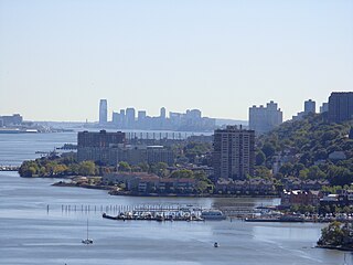
The Hudson Waterfront is an urban area of northeastern New Jersey along the lower reaches of the Hudson River, the Upper New York Bay and the Kill van Kull. Though the term can specifically mean the shoreline, it is often used to mean the contiguous urban area between the Bayonne Bridge and the George Washington Bridge that is approximately 19 miles (31 km) long. Historically, the region has been known as Bergen Neck, the lower peninsula, and Bergen Hill, lower Hudson Palisades. It has sometimes been called the Gold Coast.
Route 63 is a short, 3.09-mile (4.97 km) long state highway in Hudson and Bergen counties in New Jersey. The route is known as Bergen Boulevard and concurrent with County Route 501 for most of its alignment. The southern terminus is at Kennedy Boulevard and County Route 501 in North Bergen. The route crosses the county line and heads along the boulevard through the communities of Ridgefield, Palisades Park, and Fort Lee before reaching its northern terminus at an interchange with U.S. Route 1-9 and 46 in Fort Lee.

The George Washington Bridge Plaza, also known as GWB Plaza or Bridge Plaza, is the convergence of roads and highways around the George Washington Bridge toll plaza in Fort Lee, New Jersey, United States. The plaza is located north of and parallel to Fort Lee's Main Street. The surrounding busy area is characterized by a mix of commercial and residential uses and an architectural variety that includes parking lots, strip malls, houses, gas stations, mid-rise office buildings and high-rise condominiums. Just to the east is Fort Lee Historic Park, Palisades Interstate Park and the bridge's western tower.

Palisade Avenue is the name given to a historic road which parallels the eastern crest of Hudson Palisades in northeastern New Jersey. It travels between Jersey City and Fort Lee, passing through Jersey City Heights, North Hudson, and Cliffside Park, with various parts carrying Hudson and Bergen county route designations. The avenue re-aligns itself at several places along its route as it crosses traditional municipal boundaries created in the 19th century. As a primary route running along the top of the Hudson Palisades, many segments offer scenic views of the Hudson River and the New York skyline. Since 2020 there is proposed state legislation to restrict building heights that would rise above the cliffs on the eastern side of Palisade Avenue along the entire corridor from Jersey City to Fort Lee.


