Pavonia, New Netherland

Last updated

Pavonia was the first European settlement on the west bank of the North River (Hudson River) that was part of the seventeenth-century province of New Netherland in what would become the present Hudson County, New Jersey. [1]

Contents

Reprint of 1650 map of New Netherland Map-Novi Belgii Novaeque Angliae (Amsterdam, 1685).jpg
Reprint of 1650 map of New Netherland

Hudson and the Hackensack

The replica Half Moon at mouth of the Hudson River approaching Lower Manhattan, site of New Amsterdam, with Hoboken, part of Pavonia, in background at left Halve Maen approaching Manhattan 28 June 2009.jpg
The replica Half Moon at mouth of the Hudson River approaching Lower Manhattan, site of New Amsterdam, with Hoboken, part of Pavonia, in background at left

The first European to record exploration of the area was Robert Juet, first mate of Henry Hudson, an English sea captain commissioned by the Dutch East India Company. Their ship, the Halve Maen (Half Moon), ventured in the Kill van Kull and Newark Bay and anchored at Weehawken Cove during 1609, while exploring the Upper New York Bay and the Hudson Valley. [2] By 1617 a factorij , or trading post, was established at Communipaw. [3] [4] Others may have been established at Arresick or Hobokan Hackingh. [5]

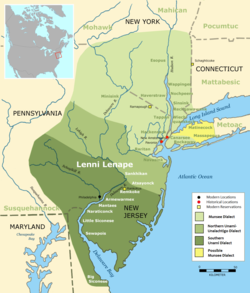
Initially, these posts were set up for fur trade with the indigenous population. At that time the area was inhabited by bands of Algonquian language speaking peoples, known collectively as Lenni Lenape and later called the Delawares. Early maps show it to be the territory of the Sangicans. [6] Later, the group of seasonally migrational people who circulated in the region were to become known by the exonym, Hackensack. They, along with the Tappan, the Wappinger, the Raritan, the Canarsee, and other groups would be known to future settlers as "the River Indians". [7]

Patroonship

Map (c1634) Pavonia located at what originally was called Oesters Eylandt, or Oyster Island, and Achter Kol, meaning Behind the Ridge and refers to Bergen Hill Hudson Valley Map Detail Nova Belgica Et Anglia Nova c1634.jpg
Map (c1634) Pavonia located at what originally was called Oesters Eylandt, or Oyster Island, and Achter Kol, meaning Behind the Ridge and refers to Bergen Hill

Further explorations and settlement led to the establishment of Fort Amsterdam at the southern tip of the island of Manhattan in 1625. In 1629, with the Charter of Freedoms and Exemptions, the Dutch West India Company started to grant the title of patroon and land patents to some of its invested members. The deeded tracts spanned 16 miles (26 km) in length on one side of a major river, or 8 miles (13 km) if spanning both sides. The title came with powerful rights and privileges, including creating civil and criminal courts, appointing local officials, and holding land in perpetuity. In return, a patroon was expected to establish a settlement of at least fifty families within four years of the original grant. These first settlers were relieved of the duty of public taxes for ten years, but were required to pay the patroon in money, goods, or services in kind.

A patent for the west bank of the North River was given to Michael Pauw, a burgermeester of Amsterdam and a director of the Dutch West India Company. Pavonia is the Latinized form of Pauw's surname, which means "peacock". [8] As was required, Pauw purchased the land from the indigenous population, although the concept of ownership differed significantly for the parties involved. Three Lenape "sold" the land for 80 fathoms (146 m) of wampum (shell beads strung together), 20 fathoms (37 m) of cloth, 12 kettles, six guns, two blankets, one double kettle, and half a barrel of beer. These transactions, dated July 12, 1630, and November 22, 1630, represent the earliest known conveyance for the area. It is said that the three were part of the same band who had sold Manhattan Island to Peter Minuit then "sold" this land, to which they had retired after that sale in 1626. On August 10, 1630, Pauw obtained a deed for Staten Island, [9] leading some historians to consider Staten Island to be part of Pavonia. [10]

Paulus Hook, Harsimus, and Communipaw

Map (around 1639) Manhattan situated on the North Rivier with numbered key showing settlements: 27. Farm (Bou=Bouwerij= (Modern Dutch) boerderij = farm) of Van Vorst; 28. "v" (sic): 29. Farm of Jan Everts; 30. Plantation at "de Laeter Hoeck"; 31. Plantation at Paulus Hook ("Poueles Hoeck"); 32. Plantation of "Maeryenes". Manatvs gelegen op de Noot Riuier.jpg
Map (around 1639) Manhattan situated on the North Rivier with numbered key showing settlements: 27. Farm (Bou=Bouwerij= (Modern Dutch) boerderij = farm) of Van Vorst; 28. "v" (sic): 29. Farm of Jan Everts; 30. Plantation at "de Laeter Hoeck"; 31. Plantation at Paulus Hook ("Poueles Hoeck"); 32. Plantation of "Maeryenes".

The area encompassed by Pauw's holdings on Bergen Neck likely included the eight miles (13 km) of shore line on each of the Hudson and Hackensack Rivers from Bergen Point to today's Bergen County line. [11] His agent set up a small factorij and ferry slip at Arresick on the tidal island that stills bears his anglicized name, Paulus Hook. He operated an intermittent ferry and traded with the local Lenape population. By 1630 a plantation worked by African slaves had been set up. [12] Pauw, however, failed to fulfill the condition of establishing a community of at least 50 permanent settlers and was required to re-sell his speculative acquisition back to the company. They commissioned construction of a homestead at Gemoenepaen for their representative Jan Evertsen Bout during 1633. During 1634 a homestead was built at Ahasimus for Cornelis Hendriksen Van Vorst (Voorst), whose later descendants would play a prominent role in the development of Jersey City. Abraham Isaacsen Verplanck received a land patent for Paulus Hook on May 1, 1638. A small farm went up at Kewan Punt. The leasehold of Aert Van Putten at Hobuk (Hoboken) was the site of North America's first brewery. Another patroonship was established farther up the river at Vriessendael. Although the settlements were small, they were strategic in that they were a foothold on the west bank of what had been named the North River across from New Amsterdam and were important trading-posts for the settlers and indigenous people, who dealt in valuable beaver pelts, and they were early attempts at populating the newly claimed territory.

Pavonia Massacre

Various groups, united after the massacre at Pavonia and Kieft's War, affected the entire province. Lenape Languages.png
Various groups, united after the massacre at Pavonia and Kieft's War, affected the entire province.

Relations between the Netherlanders and the Lenape were tenuous. Trade agreements, land ownership, familial and societal structures were misunderstood and misconstrued by both parties. Language differences most likely did not help matters. These conflicts led to rising tensions and eventually an incident that started a series of raids and reprisals, known as Kieft's War. [13]

Willem Kieft arrived in New Netherland in 1639 to take up his appointment as Director of New Netherland, with a directive to increase profits from the port at Pavonia. His solution was to attempt to exact tribute from the Indians with claims that the money would buy them protection from rival groups. It was not uncommon among the native population to do so, but in this case his demands were ignored.

At the time, the settlers in New Amsterdam were in intermittent conflict with their native Raritan and Wappinger neighbors. [14] On Staten Island, Dutch soldiers routed an encampment in retaliation for the theft of pigs, later discovered to have been stolen by other settlers. The death of a Dutch wheelwright, Claes Swits, at the hands of a Weckquaesgeek (Wappinger on the east side of the Hudson River) particularly angered many of the Dutch when the tribe would not surrender the murderer. At Achter Kol, in revenge for a theft, a Dutchman was shot with arrows while roofing a new house. [15]

Kieft decided, against the advice of the council of Twelve Men, to punish the Indians who had taken refuge among the Netherlanders (their presumed allies), when fleeing raiding Mahican from the north, by attacking Pavonia and Corlear's Hook. [7] The initial strike which he ordered on February 25, 1643, and took place at Communipaw, was a massacre: 129 Dutch soldiers killed 120 Indians, including women and children. Historians differ on whether or not the massacre was Kieft's idea. [16] [17] This is sometimes referred to as the Pavonia Massacre. [18] The same night also saw a similar if smaller attack in Manhattan, the Massacre at Corlears Hook. The Native Americans call it "The Slaughter of the Innocents". [19] This attack united the Algonquian peoples in the surrounding areas, to an extent not seen before. On October 1, 1643, a force of united "tribes" attacked the homesteads at Pavonia, most of which were burned to the ground. Many settlers were killed and those who survived were ordered to the relative safety of New Amsterdam. Pavonia was evacuated.

For the next two years during what became known as Kieft's War the united tribes harassed settlers all across New Netherland, killing sporadically and suddenly. The sparse European forces were helpless to stop the attacks, but the natives were kept too spread apart to mount more effective strikes. Finally a truce was agreed upon during August 1645, in part brokered by the Hackensack sachem, Oratam. Kieft was recalled to the Netherlands to answer for his conduct in 1647, but he died in a shipwreck before his version of events could be told. The war was extremely bloody in proportion to the population at the time: more than 1,600 natives were killed at a time when the European population of New Amsterdam was only 250. [17] The uneasy truce with the Lenape allowed for further settlement, including Constable Hook (1646) and Awiehawken (1647). [20]

Peach War and Bergen

1664 Duke's Plan includes depictions of either Harsimus, Paulus Hook, or Communipaw at time of the surrender of Fort Amsterdam. Bergen was farther inland atop Bergen Hill. Ellis Island and Liberty Island are seen lower right. Mannados.jpg
1664 Duke's Plan includes depictions of either Harsimus, Paulus Hook, or Communipaw at time of the surrender of Fort Amsterdam. Bergen was farther inland atop Bergen Hill. Ellis Island and Liberty Island are seen lower right.

Kieft's successor was Peter Stuyvesant. During 1653 Pavonia became part of the newly formed Commonality of New Amsterdam. In late 1654 a series of grants were made for tracts "achter de Kol" or Achter Col [21] at Pamrapo, Minkakwa, and Kewan. The colony grew and the situation remained relatively peaceful until 1655, when Pavonia and Staten Island were attacked by a united band of approximately five hundred Lenape. 50 settlers were killed. Over one hundred were taken hostage and held at Paulus Hook until their release could be negotiated. This incident is known as the Peach War, and is said to have been precipitated by the killing of a young Lenape woman who had stolen a peach from a settler's orchard on Manhattan Island, but may have been in response to the Dutch attack on New Sweden, the Lenape's trading partner on the Delaware River. [7] [22]

During 1658, wishing to further formalize agreements with the Lenape, Stuyvesant agreed to "re-purchase" the area "by the great rock above Wiehacken," then taking in the sweep of land on the peninsula west of the Hudson and east of the Hackensack River extending down to the Kill Van Kull in Bayonne. [23] A mural that adorns the atrium of the Hudson County Courthouse depicts this transaction: On January 30, 1658, the Peninsula between the Hudson and Hackensack rivers south from Weehawken was finally purchased from the Indians and granted to the inhabitants of Bergen in the Year 1661. [24] A new village at today's Bergen Square was founded by settlers who wished to return to the west bank of the Hudson giving it the name Bergen, which would refer to its situation. The word berg taken from the Dutch means hill, while bergen means place of safety. [25] Its semi-independent government was granted on September 5, 1661, by Stuyvesant, as part of his efforts re-gain a foothold on the North River's western shore and expand beyond New Amsterdam on the southern tip of Manhattan, under the condition that a garrison be built. Located atop Bergen Hill, it was part of the original patroonship, close to the southern end of the Hudson Palisades. It was the first self-governing European settlement in what would become the state of New Jersey.

During 1664, Fort Amsterdam and, by extension, all of New Netherland was peacefully surrendered to the British. For the next ten years it was traded at the negotiating table and, for a short period, recaptured. The Dutch Empire finally relinquished control with the Treaty of Westminster during 1675. Bergen's charter was renewed by the government of East Jersey and the area retained its Dutch character for years.

Modern Pavonia

Newport, built on the previously landfilled Harsimus Cove from the Hudson River Newport, Jersey City waterfront, skyline.jpg
Newport, built on the previously landfilled Harsimus Cove from the Hudson River
Pavonia branch library Pavonia JCFPL jeh.jpg
Pavonia branch library

Although the entire region was originally Pavonia, the name now tends to be associated with the former Jersey City area of the Horseshoe encompassing Harsimus Cove, Hamilton Park, and WALDO-Powerhouse. Since the 1980s the former site of the Erie Railroad's Hudson waterfront Pavonia Terminal and the Pavonia Ferry has been redeveloped as Newport. The PATH rapid transit system's Newport Station, formerly called Pavonia, and the Hudson Bergen Light Rail Pavonia-Newport station are in this section of the city.

Pavonia Avenue is a street interrupted in sections as it runs east-west in Pavonia Newport, at Hamilton Park, in Journal Square, and in the Marion Section. Pavonia Court, at the Newark Bay in Bayonne has its name from the Pavonia Yacht Club established during 1859 on the New York Bay. There is also a Pavonia Avenue in Kearny. Saint Peter's College, located on land that was part of the patroonship, has as its mascot a peacock, to which its publications make reference: Pauw Wow (newspaper), Pavan (literary magazine), Peacock Pie (yearbook). There is also a Pavonia Branch of the Jersey City Free Public Library. [26] The Pavonia Yard streetcar depot was located near Five Corners. [27] The Pavonia Yard, located in Camden. [28] was operated by the Pennsylvania Railroad, which also maintained terminals and yards in Downtown Jersey City.

See also

Related Research Articles

The Twelve Men was a council of 12 citizens chosen by the residents of New Netherland to advise Director Willem Kieft, on relations with the Native Americans in the wake of the murder of Claes Swits. Elected on 29 August 1641, the temporary council was the first representational form of democracy in the Dutch colony. The next two such bodies were known as the Eight Men and the Nine Men.

In the United States, a patroon was a landholder with manorial rights to large tracts of land in the 17th century Dutch colony of New Netherland on the east coast of North America. Through the Charter of Freedoms and Exemptions of 1629, the Dutch West India Company first started to grant this title and land to some of its invested members. These inducements to foster colonization and settlement are the basis for the patroon system. By the end of the eighteenth century, virtually all of the American states had abolished primogeniture and entail; thus patroons and manors evolved into simply large estates subject to division and leases.

Bergen Township was a township that existed in the U.S. state of New Jersey, from 1661 to 1862, first as Bergen, New Netherland, then as part Bergen County, and later as part of Hudson County. Several places still bear the name: the township of North Bergen; Bergen Square, Old Bergen Road, Bergen Avenue, Bergen Junction, Bergen Hill and Bergen Arches in Jersey City; Bergen Point in Bayonne; and Bergenline Avenue and Bergen Turnpike in North Hudson.

<span class="mw-page-title-main">Kieft's War</span> Conflict in 1643-45 between Dutch colonists and Lenape Indians

Kieft's War (1643–1645), also known as the Wappinger War, was a conflict between the colonial province of New Netherland and the Wappinger and Lenape Indians in what is now New York and New Jersey. It is named for Director-General of New Netherland Willem Kieft, who had ordered an attack without the approval of his advisory council and against the wishes of the colonists. Dutch colonists attacked Lenape camps and massacred the inhabitants, which encouraged unification among the regional Algonquian tribes against the Dutch and precipitated waves of attacks on both sides. This was one of the earliest conflicts between settlers and Indians in the region. The Dutch West India Company was displeased with Kieft and recalled him, but he died in a shipwreck while returning to the Netherlands; Peter Stuyvesant succeeded him in New Netherland. Numerous Dutch settlers returned to the Netherlands because of the continuing threat from the Algonquians, and growth slowed in the colony.

<span class="mw-page-title-main">Bergen Square</span> Populated place in Hudson County, New Jersey, US

Bergen Square, at the intersection of Bergen Avenue and Academy Street in Jersey City, is in the southwestern part of the much larger Journal Square district. A commercial residential area, it contains an eclectic array of architectural styles including 19th-century row houses, Art Deco retail and office buildings, and is the site of the longest continually-used school site in the United States. Nearby are the Van Wagenen House and Old Bergen Church, two structures from the colonial period. St. George & St. Shenouda Coptic Orthodox Church founded by early Egyptian immigrants was one of the original Coptic congregations in New Jersey.

<span class="mw-page-title-main">Vriessendael, New Netherland</span>

Vriessendael was a patroonship on the west bank of the Hudson River in New Netherland, the seventeenth century North American colonial province of the Dutch Empire. The homestead or plantation was located on a tract of about 500 acres (2.0 km2) about an hour's walk north of Communipaw at today's Edgewater. It has also been known as Tappan, which referred to the wider region of the New Jersey Palisades, rising above the river on both sides of the New York/New Jersey state line, and to the indigenous people who lived there and were part of wider group known as Lenape. It was established in 1640 by David Pietersen de Vries, a Dutch sea captain, explorer, and trader who had also established settlements at the Zwaanendael Colony and on Staten Island. The name can roughly be translated as De Vries' Valley. De Vries also owned flatlands along the Hackensack River, in the area named by the Dutch settlers Achter Col. Parts of Vriessendael were destroyed in 1643 in reprisal for the slaughter of Tappan and Wecquaesgeek Native Americans who had taken refuge at Pavonia and Corlears Hook. The patroon's relatively good relations with the Lenape prevented the murder of the plantation's residents, who were able to seek sanctuary in the main house, and later flee to New Amsterdam. The incident was one of the first of many to take place during Kieft's War, a series of often bloody conflicts with bands of Lenape, who had united in face of attacks ordered by the Director of New Netherland.

<span class="mw-page-title-main">Achter Kol, New Netherland</span>

Achter Kol was the name given to the region around the Newark Bay and Hackensack River in northeastern New Jersey by the first European settlers to it and was part of the 17th century province of New Netherland, administered by the Dutch West India Company. At the time of their arrival, the area was inhabited by the Hackensack and Raritan groups of Lenape natives.

<span class="mw-page-title-main">Bergen, New Netherland</span> Origin of the New Jersey settlement

Bergen was a part of the 17th century province of New Netherland, in the area in northeastern New Jersey along the Hudson and Hackensack Rivers that would become contemporary Hudson and Bergen Counties. Though it only officially existed as an independent municipality from 1661, with the founding of a village at Bergen Square, Bergen began as a factory at Communipaw circa 1615 and was first settled in 1630 as Pavonia. These early settlements were along the banks of the North River across from New Amsterdam, under whose jurisdiction they fell.

Oratam was sagamore, or sachem, of the Hackensack Indians living in northeastern New Jersey during the period of early European colonization in the 17th century. Documentation shows that he lived an unusually long life and was quite influential among indigenous and immigrant populations.

Hackensack was the exonym given by the Dutch colonists to a band of the Lenape, or Lenni-Lenape, a Native American tribe. The name is a Dutch derivation of the Lenape word for what is now the region of northeastern New Jersey along the Hudson and Hackensack rivers. While the Lenape people occupied much of the mid-Atlantic area, Europeans referred to small groups of native people by the names associated with the places where they lived.

Communipaw is a neighborhood in Jersey City in Hudson County, in the U.S. state of New Jersey. It is located west of Liberty State Park and east of Bergen Hill, and the site of one of the earliest European settlements in North America. It gives its name to the historic avenue which runs from its eastern end near Liberty State Park Station through the neighborhoods of Bergen-Lafayette and the West Side that then becomes the Lincoln Highway. Communipaw Junction, or simply The Junction, is an intersection where Communipaw, Summit Avenue, Garfield Avenue, and Grand Street meet, and where the toll house for the Bergen Point Plank Road was situated. Communipaw Cove at Upper New York Bay, is part of the 36-acre (150,000 m2) state nature preserve in the park and one of the few remaining tidal salt marshes in the Hudson River estuary.

<span class="mw-page-title-main">Michiel Reyniersz Pauw</span>

Knight Michiel Reiniersz Pauw was a director of the Dutch West India Company (WIC) between 1621 and 1636. He is buried at at Nieuwe Kerk, Amsterdam.

<span class="mw-page-title-main">Tappan people</span> Native tribe of the lower Hudson River

The Tappan were a Lenape people who inhabited the region radiating from Hudson Palisades and New York – New Jersey Highlands at the time of European colonialization in the 17th century.

<span class="mw-page-title-main">New Netherlander</span> Historical cultural group of colonial New York, New Jersey, and Pennsylvania

New Netherlanders were residents of New Netherland, the seventeenth-century colonial outpost of the Republic of the Seven United Netherlands on the northeastern coast of North America, centered on the Hudson River and New York Bay, and in the Delaware Valley.

<span class="mw-page-title-main">Harsimus</span> Populated place in Hudson County, New Jersey, US

Harsimus is a neighborhood within Downtown Jersey City, Hudson County, in the U.S. state of New Jersey. The neighborhood stretches from the Harsimus Stem Embankment on the north to Christopher Columbus Drive on the south between Coles Street and Grove Street or more broadly, to Marin Boulevard. It borders the neighborhoods of Hamilton Park to the north, Van Vorst Park to the south, the Village to the west, and the Powerhouse Arts District to the east. Newark Avenue has traditionally been its main street. The name is from the Lenape, used by the Hackensack Indians who inhabited the region and could be translated as Crow's Marsh. From many years, the neighborhood was part of the "Horseshoe", a political delineation created by its position between the converging rail lines and political gerrymandering.

<span class="mw-page-title-main">Charter of Freedoms and Exemptions</span> Charter of New Netherland

The Charter of Freedoms and Exemptions, sometimes referred to as the Charter of Privileges and Exemptions, is a document written by the Dutch West India Company in an effort to settle its colony of New Netherland in North America through the establishment of feudal patroonships purchased and supplied by members of the West India Company. Its 31 articles establish ground rules and expectations of the patroons and inhabitants of the new colonies. It was ratified by the Dutch States-General on June 7, 1629.

Maryn Adriansen was an early settler to New Netherland. Originally emigrating under an Indenture agreement he later became a prominent member of society. His conflict with the governor led to accusations and, eventually, acquittal. He owned property in New Amsterdam and a large plantation at Awiehaken.

Abraham Isaacsen Verplanck (1606–1690), also known as Abraham Isaacse Ver Planck, was an early and prominent settler in New Netherlands. A land developer and speculator, he was the progenitor of an extensive Verplanck family in the United States. Immigrating circa 1633, he received a land grant at Paulus Hook in 1638.

References

  1. Karnoutsos, Carmela. "Pavonia". New Jersey City University. Retrieved September 14, 2014.
  2. Juet's Journal
  3. Joan F. Doherty, Hudson County The Left Bank, ISBN   0-89781-172-0 (Windsor Publications, Inc., 1986)
  4. "The English and Dutch Towns of New Netherland". American Historical Review. penelope.uchicago.edu (University of Chicago). October 1900. pp. 1–18. Retrieved December 15, 2011.
  5. Perhaps at Paulus Hook, in what is now Jersey City, or else at Castle Point, the trading station of Hobokan Hackingh. From either one of these places the runners may have made their way to what is now Elizabeth, N. J., and thence followed an Indian trail to the bend in the Delaware, near Trenton, N. J. (See R. P. Bolton, Indian Paths in the Great Metropolis Lin the series of Indian Notes and Monographs published by the Museum of the American Indian, Heye Foundation, pp. 198–99, and map of eastern New Jersey, of 1747, in the same volume.) De Vries says that when Michiel Pauw, during 1630, discovered that other directors of the West India Company had appropriated the land at Fort Orange for themselves, he "immediately had the land below, opposite Fort Amsterdam, where the Indians are compelled to cross to the fort with their beavers, registered for himself, and called it Pavonia." (J. F. Jameson, Narratives of New Netherland, p. 210.)
  6. 1614 Block Map
  7. 1 2 3 Ruttenber, E. M. (1872). History of the Indian Tribes of Hudson's River. Albany, New York: J. Munsell.
  8. "Patroon of Pavonia". Archived from the original on May 12, 2008. Retrieved April 19, 2008.
  9. Winfield, Charles, History of the County of Hudson, New Jersey, from Its Earliest Settlement to the Present Time p. 17 Accessed 12/5/2014
  10. Richardson, William H. (1933) When Staten Island was New Jersey: paper prepared for the New Jersey Historic Congress, Atlantic City, March 24/25, 1933
  11. "Jan Evertsen Bout at Pavonia". Archived from the original on September 4, 2017. Retrieved January 11, 2009.
  12. Hodges, Graham Rusell (1999). "Free People and Slaves, 1613–1664". Dutch New York:Roots and Branch:African Americans in New York and East Jersey. Chapel Hill: University of North Carolina Press. p. 9. ISBN   0-8078-4778-X.
  13. https://www.publichistoryproject.org/remembering-pavonia/#pavonia-history
  14. Sultzman, Lee (1997). "Wappinger History" . Retrieved July 5, 2006.
  15. E. M. Ruttenber, Indian Tribes of Hudson's River to 1700, 3rd ed., ISBN   0-910746-98-2, (Hope Farm Press, 2001)
  16. Winkler, David F. (1998). Revisiting the Attack on Pavonia. New Jersey Historical Society.
  17. 1 2 Beck, Sanderson (2006). "New Netherland and Stuyvesant 1642–64".
  18. Kiefts War
  19. Jean, Terri (2003). 365 Days of Walking the Red Road . Avon, MA: Adams Media Corporation. ISBN   978-1-58062-849-5.
  20. Clayton, W.W.; William Nelson (1882). History of Bergen and Passaic counties, New Jersey, with biographical sketches of many of its pioneers and prominent men. Philadelphia: Everts and Peck. p. 33.
  21. History of New Netherland, E.B. Callaghan (c) 1855
  22. Russell Shorto (2004). The Island at the Center of the World: The Epic Story of Dutch Manhattan and the Forgotten Colony that Shaped America. Random House. ISBN   1-4000-7867-9.
  23. History of the County of Hudson, New Jersey, from Its Earliest Settlement to the Present Time, p. 62, accessed March 29, 2007
  24. Mural photo
  25. Grundy, J. Owen (1975). "A Dutch Legacy". The History of Jersey City (1609–1976). Jersey City: Walter E. Knight; Progress Printing Company. p. 5.
  26. "JC Public Library Pavonia". Archived from the original on November 1, 2010. Retrieved October 22, 2009.
  27. Pavonia Yard streetcar depot Archived July 8, 2009, at the Wayback Machine
  28. Pavonia, Camden Map

Sources

40°43′25″N74°02′33″W / 40.7237°N 74.0424°W / 40.7237; -74.0424