Marion Section

Last updated

Marion Section
Tonnelle circle usgs.jpg
Aerial view of the warehouse district in the Marion Section of Jersey City, between the PATH train tracks and the Pulaski Skyway
Location map of Hudson County, New Jersey.svg
Red pog.svg
Marion Section
Marion in Hudson County in New Jersey
Coordinates: 40°44′07″N74°04′27″W / 40.73528°N 74.07417°W / 40.73528; -74.07417
Country Flag of the United States.svg  United States
State Flag of New Jersey.svg  New Jersey
County Hudson
City Jersey City
Elevation
[1]
26 ft (8 m)
Area code 201
GNIS feature ID878120 [1]

Marion is a section of Jersey City in Hudson County, in the U.S. state of New Jersey. [2] [3]

Contents

History

The Marion Section was laid out in the 1870s and was developed in the early 20th century. The name is speculated to have come from either the old Marion Hotel or the founders of a watch company located near the city line. Marion Junction, an important rail junction in the 19th century is nearby. Originally concentrated with families of Italian ancestry, Marion was planned as a blue- collar residential community to work at Lorillard Tobacco Company, American Can Company, or nearby railroad yards.

Description

Sidestreet off Broadway Marion Section Jersey City Broadway side street.jpg
Sidestreet off Broadway

To the west of Journal Square and north of Holy Name Cemetery on the West Side, the Marion's two distinct neighborhoods are separated by PATH train tracks. It borders other districts of Riverbend, Croxton and the West Side, and is sometimes considered to include the area along the Hackensack Riverfront, Tonnele Circle, and neighborhood overlapping India Square. Marion is mostly a low-rise residential district that is home to several new housing developments, light manufacturing, restaurants, LaPointe Park and the Marion Branch Public Library. Broadway, U.S. Route 1/9, Sip Avenue and West Side Avenue are the main streets running through the neighborhood. The 1940 Marion Gardens housing project creates the western residential border for the section. [4]

The area north of the tracks near the foot of on Newark Avenue and east of Marion Junction is surrounded by manufacturing and warehouse buildings, a few of which have received New Jersey Register of Historic Places designation. Some have been converted to residences or other uses, notably that of the American Can Company. [5] [6] The Middle East Center for the Arts (MECA) [7] is an exhibition space at Mana Contemporary [8] [9] also housed in a former manufacturing building and that is an extension of the fine arts transportation department of Moishe's Moving Systems. [10] The 1,000,000 (one million)-square foot building is also home to dance companies of Shen Wei and Karole Armitage. [11]

Skyway Park has received funding and eventually will connect to the Hackensack RiverWalk with a 1,300-foot (400 m) extension to Lincoln Park and the East Coast Greenway. The reclaimed brownfield will be transformed to a 32-acre waterfront park including two soccer fields, a drill/practice area, a lawn/fairgrounds, and a mile long jogging/walking path. [12] [13] [14] [15] Portions were once part of the PJP Landfill. [16]

India Square is a neighborhood in the Journal Square and Marion neighborhoods. [17] It is home to one of the highest concentrations of Asian Indians in the Western Hemisphere [18] and one of at least 24 enclaves characterized as a Little India which have emerged within the New York City Metropolitan Area. Little Bombay is centered by India Square, a two-block stretch of Newark Avenue home to over 13,000 people of Indian origin. [19] As of the 2010 Census, the area had a population of over 27,000, with the majority being of Indian descent. [20] As of the 2010 census, over 27,000 Asian Indians accounted for 10.9% of Jersey City's population. [21]

Potential PATH station

The neighborhood separated by PATH tracks crossed by a pedestrian bridge Marion, Jersey City bridge over PATH.jpg
The neighborhood separated by PATH tracks crossed by a pedestrian bridge

Although the PATH train runs through the district, there is no station there. During his terms as Mayor of Jersey City in the 1980s and 1990s, Gerald McCann called for a new station. [22] Another former mayor, Jerramiah Healy also requested that a PATH stop be built at Broadway and West Side Avenue, [23] augmenting service at the nearest station at Journal Square. There are a growing number housing units being built in the Marion Section and government officials find a stop on the PATH system will be necessary to unclog the city streets and lessen the commute for residents and to bolster development in the neighborhood, which has fewer cultural attractions than others in the city. [24] [25] The city entered into an agreement in 2018 that the agency would conduct a feasibility study. [26] [27] [24] [28] After some delays, the report was completed in 2020. [29] [24] [30]

See also

Related Research Articles

<span class="mw-page-title-main">Hudson County, New Jersey</span> County in New Jersey, United States

Hudson County is the smallest and most densely populated county in the U.S. state of New Jersey. It lies west of the lower Hudson River, which was named for Henry Hudson, the sea captain who explored the area in 1609. Part of New Jersey's Gateway Region in the New York metropolitan area, the county seat is Jersey City, which is the county's largest city in terms of both population and area.

<span class="mw-page-title-main">Journal Square Transportation Center</span> Transportation center in Jersey City, New Jersey

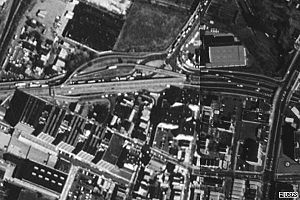
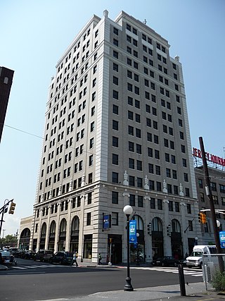
The Journal Square Transportation Center is a multi-modal transportation hub located on Magnolia Avenue and Kennedy Boulevard at Journal Square in Jersey City, New Jersey, United States. Owned and operated by the Port Authority of New York and New Jersey, the complex includes a ten-story tower, a retail plaza, a bus terminal, a two-level parking facility, and the Journal Square station of the PATH rail transit system. The underground station has a high ceiling and a mezzanine level connecting the platforms.

<span class="mw-page-title-main">White Manna</span> American fast food restaurant

White Manna and White Mana are the names of two fast food diners in the U.S. state of New Jersey, named after manna, the Biblical food. The restaurants were ranked on America's best burgers list along with White Rose Hamburgers, another New Jersey burger joint.

Paterson Plank Road is a road that runs through Passaic, Bergen and Hudson Counties in northeastern New Jersey. The route, originally laid in the colonial era, connects the city of Paterson and the Hudson River waterfront. It has largely been superseded by Route 3, but in the many towns it passes it has remained an important local thoroughfare, and in some cases been renamed.

<span class="mw-page-title-main">Journal Square</span> Journal Square in Jersey City, New Jersey

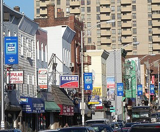
Journal Square is a business district, residential area, and transportation hub in Jersey City, New Jersey, which takes its name from the newspaper Jersey Journal whose headquarters were located there from 1911 to 2013. The "square" itself is at the intersection of Kennedy Boulevard and Bergen Avenue. The broader area extends to and includes Bergen Square, McGinley Square, India Square, the Five Corners and parts of the Marion Section. Many local, state, and federal agencies serving Hudson County maintain offices in the district.

<span class="mw-page-title-main">Croxton, Jersey City</span> Populated place in Hudson County, New Jersey, US

Croxton is a section of Jersey City in the New Jersey Meadowlands in Hudson County, in the U.S. state of New Jersey.

<span class="mw-page-title-main">India Square</span> Populated place in Hudson County, New Jersey, US

India Square, also known as "Little India," is a commercial and restaurant district in the Journal Square and Marion Section neighborhoods of Jersey City, New Jersey, US.

<span class="mw-page-title-main">Bayfront, Jersey City</span> Populated place in Hudson County, New Jersey, US

Bayfront is an urban redevelopment project in Jersey City, New Jersey.

<span class="mw-page-title-main">Hackensack River Greenway</span> Trail along the lower Hackensack River

Hackensack River Greenway, once known as the Hackensack RiverWalk, a is partially constructed greenway along the Newark Bay and Hackensack River in Hudson County, New Jersey, United States.

Communipaw is a neighborhood in Jersey City in Hudson County, in the U.S. state of New Jersey. It is located west of Liberty State Park and east of Bergen Hill, and the site of one of the earliest European settlements in North America. It gives its name to the historic avenue which runs from its eastern end near Liberty State Park Station through the neighborhoods of Bergen-Lafayette and the West Side that then becomes the Lincoln Highway. Communipaw Junction, or simply The Junction, is an intersection where Communipaw, Summit Avenue, Garfield Avenue, and Grand Street meet, and where the toll house for the Bergen Point Plank Road was situated. Communipaw Cove at Upper New York Bay, is part of the 36-acre (150,000 m2) state nature preserve in the park and one of the few remaining tidal salt marshes in the Hudson River estuary.

<span class="mw-page-title-main">West Side, Jersey City</span> Populated place in Hudson County, New Jersey, US

The West Side of Jersey City is an area made up of several diverse neighborhoods on either side of West Side Avenue, one of the city's main shopping streets. Parallel and west of Kennedy Boulevard, West Side Avenue carries two county route designations.

<span class="mw-page-title-main">Hudson Waterfront</span> Place in Hudson and Bergen

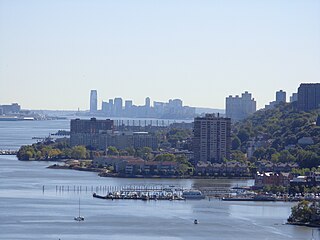
The Hudson Waterfront is an urban area of northeastern New Jersey along the lower reaches of the Hudson River, the Upper New York Bay and the Kill van Kull. Though the term can specifically mean the shoreline, it is often used to mean the contiguous urban area between the Bayonne Bridge and the George Washington Bridge that is approximately 19 miles (31 km) long. Historically, the region has been known as Bergen Neck, the lower peninsula, and Bergen Hill, lower Hudson Palisades. It has sometimes been called the Gold Coast.

<span class="mw-page-title-main">Riverbend (Hudson County)</span> Populated places in Hudson County, New Jersey, US

Riverbend is the name of two sections of Hudson County, New Jersey.

<span class="mw-page-title-main">Summit Avenue (Hudson Palisades)</span> Road in Hudson County, New Jersey, US

County Route 617 is 4.55-mile (7.32 km) long and follows one street, Summit Avenue along the ridge of the Hudson Palisades in Hudson County, New Jersey. Its southern end is CR 622, or Grand Street, at Communipaw Junction in the Bergen-Lafayette Section of Jersey City. Its northern end is CR 691, 32nd Street, a section of the Bergen Turnpike, in Union City.

<span class="mw-page-title-main">Canal Crossing, Jersey City</span> Populated place in Hudson County, New Jersey, US

Canal Crossing is a New Urbanism project on the eastern side of Jersey City, New Jersey between Jackson Hill in Greenville/Bergen-Lafayette and Liberty State Park. The approximately 111 acre area, previously designated for industrial and distribution uses has been re-zoned for transit-oriented residential and commercial use and the construction of a neighborhood characterized as a sustainable community. The name is inspired by the Morris Canal, which once traversed the district in a general north and south alignment. The brownfield site must first undergo remediation of toxic waste, much of it left by PPG Industries The redevelopment plans call for 7,000 housing units, mainly "mid-rise" buildings, and a greenway along the former canal, directly south of the 17-acre Berry Lane Park.

The United States Environmental Protection Agency added the PJP Landfill site in Marion Section of Jersey City, New Jersey to the Superfund National Priorities List on September 1, 1983, because hazardous chemicals were found in the soil and groundwater. The 87-acre site located in Hudson County contained a landfill that may have been used as early as 1968 to dispose of chemical and industrial wastes. In 1971 the State certified the landfill to receive solid wastes. Approximately 11,900 people currently reside within a one-mile radius of the site. The west side of the site is bordered by the Hackensack River which is used for boating and commercial shipping. Recently, AMB Corporation purchased a portion of the site.

<span class="mw-page-title-main">Mana Contemporary</span> Contemporary art center in Jersey City, New Jersey

Mana Contemporary is a cultural center in Jersey City, New Jersey, United States with affiliated centers in Chicago and Miami.

Skyway Park is a 32-acre (13 ha) park being developed in Jersey City, New Jersey on the Hackensack River, partly under the Pulaski Skyway, from which it takes its name. The brownfield land was the site of the PJP Landfill. It is a component of the Hackensack RiverWalk, a linear park along the banks of the river and Newark Bay.

References

  1. 1 2 "Marion". Geographic Names Information System . United States Geological Survey, United States Department of the Interior.
  2. Locality Search, State of New Jersey. Accessed February 7, 2015.
  3. "Jersey City's Districts". Archived from the original on August 20, 2008. Retrieved April 1, 2009.
  4. "Marion Gardens". Archived from the original on December 10, 2009. Retrieved February 21, 2010.
  5. Kaysen, Ronda (February 12, 2016). "Moving to Jersey City? Join the Club". The New York Times. ISSN   0362-4331 . Retrieved May 27, 2021.
  6. "American Can Company to become 202 condos; may see 600 in total". Jersey City Reporter. Archived from the original on August 25, 2007. Retrieved April 15, 2008. ... American Can Company located between Dey Street and St. Paul's Avenue ... The American Can Company was spread over a series of five buildings on St. Paul's Avenue. Only two of the five buildings will be turned into the 202 units right now, although another 398 units may be built in the other three buildings in future phases.
  7. "Middle East Center for the Arts (MECA)". themeca.org. Retrieved April 1, 2012.
  8. "Mana Contemporary". www.manafinearts.com. Retrieved April 1, 2012.
  9. Musat, Stephanie (March 31, 2012), New art center focused on Middle East to open in Jersey City
  10. Kozinn, Allan (May 16, 2013). "From Moving Van to Art Complex". The New York Times. Retrieved May 18, 2013.
  11. "'Punk Ballerina' Karole Armitage Finds a New Home at Mana Contemporary". The Jersey City Independent. Retrieved May 8, 2016.
  12. "Marion Greenway Park".
  13. "First Phase of Landfill-to-Park Redevelopment on Hackensack Riverfront Slated to Be Complete This Summer". The Jersey City Independent. Retrieved May 8, 2016.
  14. "Jersey City Council voting on final step to make landfill a park". NJ.com. April 14, 2010. Retrieved May 8, 2016.
  15. "Forty Jersey City residents briefed on new 32-acre park to be built on cleaned-up landfill". NJ.com. May 29, 2012. Retrieved May 8, 2016.
  16. "Jersey City park to be built on former PJP landfill site". NJ.com. May 29, 2012. Retrieved May 8, 2016.
  17. Kiniry, Laura. "Moon Handbooks New Jersey", Avalon Travel Publishing, 2006. pg. 34 ISBN   1-56691-949-5
  18. Laryssa Wirstiuk (April 21, 2014). "Neighborhood Spotlight: Journal Square". Jersey City Independent. Archived from the original on June 30, 2018. Retrieved December 26, 2014.
  19. "India Square" Archived October 15, 2013, at the Wayback Machine , accessed May 16, 2018
  20. "City Attracts People From Around the Globe" Archived 2011-05-16 at the Wayback Machine . Accessed July 26, 2006.
  21. "Profile of General Population and Housing Characteristics: 2010 Demographic Profile Data Jersey City, New Jersey". U.S. Census Bureau. Retrieved May 15, 2018.
  22. 1 2 Torres, Agustin C. (July 15, 2009). "Marion needs a PATH station". NJ.com. Retrieved May 8, 2016.
  23. "Newe PATH Station in Jersey City Marion: PATH Trains Hudson Tubes Hudson& Manhattan RR" . Retrieved May 8, 2016.
  24. 1 2 3 Sullivan, Al (April 24, 2022). "Is a New Path for Public Transit Coming to Jersey City? Station Would Use Previously Constructed Tracks". TapINto. Retrieved August 16, 2023.
  25. Marion PATH Station?, Jersey Journal , May 15, 2006
  26. Fry, Chris (November 20, 2018). "Port Authority Could Soon Study Feasibility of Marion PATH Station in Jersey City". Jersey Digs. Retrieved May 27, 2021.
  27. McDonald, Terrence T. (November 27, 2018). "Legal settlement: millions for Jersey City, new home for PATH substation". NJ.com. Retrieved May 27, 2021.
  28. Heinis, John (April 8, 2022). "Fulop, Tom DeGise, & Bob Menendez all in favor of Marion Street PATH Station in Jersey City". Hudson County View.
  29. Marion PATH Station Physical Feasibility Study (PDF) (Report). Hatch. January 2020.
  30. Fry, Chris (May 10, 2022). "Renderings Revealed for Development on Jersey City's Giles Avenue". Jersey Digs.