West Side, Jersey City

Last updated

The West Side of Jersey City is an area made up of several diverse neighborhoods on either side of West Side Avenue, [1] one of the city's main shopping streets. [2] [3] Parallel and west of Kennedy Boulevard, West Side Avenue carries two county route designations. [4] [5]

West Side Avenue at its northern end begins in the Marion Section as a dead end at the PATH trains, though there is no station there [6] After crossing Broadway and Sip Avenue it passes Holy Name Cemetery on the west and nearby Saint Peter's University to the east. [7] "The Bubble", an air-supported structure that is part of Yanitelli Center, is visible on the slope of Montgomery Street.[ citation needed ]

Lincoln Park and Pulaski Skyway Pulaski Skyway fr Lincoln Pk jeh.JPG
Lincoln Park and Pulaski Skyway

Lincoln Park is one of the largest county parks in Hudson County [8] and includes recreational facilities (tennis, track, athletic fields, golf range, biking, running) and picnicking areas. Overpasses provide pedestrian access over Truck 1-9 from the older, more urban eastern section of the park to the more natural west section on the Hackensack River. The streets ascending from the park contain an eclectic mix of architectural styles including Victorian and Edwardian mansions, and pre-war and Art Deco apartment buildings in the Bergen Section. St Aloyius Church is a prominent landmark near the park. [9]

Mallory Square, a small Filipino American neighborhood in the Lincoln Park/West Bergen area of Jersey City's West Side Mallory Square.jpg
Mallory Square, a small Filipino American neighborhood in the Lincoln Park/West Bergen area of Jersey City's West Side

At Communipaw Avenue the street enters the heart of West Bergen. [2] [10] [11] West Bergen is so called in reference Bergen-Lafayette Section and in the 19th century was part of Bergen Township and Bergen. (The name Bergen is from the original Bergen, New Netherland centered on Bergen Square). One of the very few older residential districts of the city west of the avenue radiates from Mallory Avenue as it runs south from Lincoln Park.

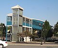
The West Side Avenue Station is the terminus for the single branch of the Hudson Bergen Light Rail. [12] The station is on an embankment above the east side of street, and consists of an island platform and two tracks. Bumper blocks are at the west end of the station, a pedestrian bridge and elevator connecting it a large park and ride lot and bus stations. The former Central Railroad of New Jersey right of way formerly continued west across the Newark and New York Railroad Bridge at Newark Bay and there are proposals to extend the line to a station close by. The Jersey City Board of Education is located nearby.

The West Campus of New Jersey City University began development in 2006, and will more than double the campus's with academic buildings, residences, retail spaces, parking, and a "University Promenade." [13] [14] [15] Along with Bayfront, Jersey City, another planned community, the West Side will be expanded with residential, retail, and recreational areas.

West Side Avenue's southern end is the Country Village [16] section of Greenville at Danforth Avenue close to NJ-440, [7] across which is the Droyer's Point and completed sections of the Hackensack RiverWalk.

Several New Jersey Transit bus routes serve the district.

See also

Related Research Articles

<span class="mw-page-title-main">New Jersey Route 5</span> State highway in Bergen County, New Jersey, US

Route 5 is a 3.18-mile (5.12 km) state highway located entirely in Bergen County, New Jersey, United States. It runs from U.S. Route 1/9 (US 1-9) in Ridgefield east down the New Jersey Palisades to end at County Route 505 at the Hudson River in Edgewater, forming a “wavy” path. The route is a two- to four-lane undivided highway its entire length, passing mostly through wooded residential neighborhoods. The route passes under Route 63 in Palisades Park, with access to that route provided by Bergen Boulevard, and intersects the southern terminus of Route 67 in Fort Lee.

<span class="mw-page-title-main">New Jersey Route 17</span> State highway in Bergen County, New Jersey, US

Route 17 is a state highway in Bergen County, New Jersey, United States, that provides a major route from the George Washington Bridge, Lincoln Tunnel and other northeast New Jersey points to the New York State Thruway at Suffern, New York. It runs 27.20 mi (43.77 km) from an intersection with Route 7 and County Route 507 (CR 507) in North Arlington north to the New York border along Interstate 287 (I-287) in Mahwah, where New York State Route 17 (NY 17) continues into New York. Between Route 7 and Route 3 in Rutherford, Route 17 serves as a local road. From Route 3 north to the junction with U.S. Route 46 (US 46) in Hasbrouck Heights, the road is an arterial road with jughandles. The portion of Route 17 from US 46 to I-287 near the state line in Mahwah is a four- to six-lane arterial with all cross traffic handled by interchanges, and many driveways and side streets accessed from right-in/right-out ramps from the right lane. For three miles (5 km) north of Route 4, well over a hundred retail stores and several large shopping malls line the route in the borough of Paramus. The remainder of this portion of Route 17 features lighter suburban development. The northernmost portion of Route 17 in Mahwah runs concurrently with I-287 to the New York border.

<span class="mw-page-title-main">Hudson–Bergen Light Rail</span> Light rail system in New Jersey, United States

The Hudson–Bergen Light Rail (HBLR) is a light rail system in Hudson County, New Jersey, United States. Owned by New Jersey Transit (NJT) and operated by the 21st Century Rail Corporation, it connects the communities of Bayonne, Jersey City, Hoboken, Weehawken, Union City, at the city line with West New York, and North Bergen.

<span class="mw-page-title-main">Greenville, Jersey City</span> Populated place in Hudson County, New Jersey, US

Greenville is the southernmost section of Jersey City in Hudson County, in the U.S. state of New Jersey.

Paterson Plank Road is a road that runs through Passaic, Bergen and Hudson Counties in northeastern New Jersey. The route, originally laid in the colonial era, connects the city of Paterson and the Hudson River waterfront. It has largely been superseded by Route 3, but in the many towns it passes it has remained an important local thoroughfare, and in some cases been renamed.

<span class="mw-page-title-main">Hackensack Plank Road</span>

The Hackensack Plank Road, also known as Bergen Turnpike, was a major artery which connected the cities of Hoboken and Hackensack, New Jersey. Like its cousin routes, the Newark Plank Road and Paterson Plank Road, it travelled over Bergen Hill and across the Hackensack Meadows from the Hudson River waterfront to the city for which it was named. It was originally built as a colonial turnpike road as Hackensack and Hoboken Turnpike. The route mostly still exists today, though some segments are now called the Bergen Turnpike. It was during the 19th century that plank roads were developed, often by private companies which charged a toll. As the name suggests, wooden boards were laid on a roadbed in order to prevent horse-drawn carriages and wagons from sinking into softer ground on the portions of the road that passed through wetlands. The company that built the road received its charter on November 30, 1802. The road followed the route road from Hackensack to Communipaw that was described in 1679 as a "fine broad wagon-road."

<span class="mw-page-title-main">Bayfront, Jersey City</span> Populated place in Hudson County, New Jersey, US

Bayfront is an urban redevelopment project in Jersey City, New Jersey.

<span class="mw-page-title-main">Bergen Hill</span> Lower part of the Hudson Palisades, New Jersey, United States

Bergen Hill refers to the lower Hudson Palisades in New Jersey, where they emerge on Bergen Neck, which in turn is the peninsula between the Hackensack and Hudson Rivers, and their bays. In Hudson County, it reaches a height of 260 feet.

<span class="mw-page-title-main">Hackensack River Greenway</span> Trail along the lower Hackensack River

Hackensack River Greenway, once known as the Hackensack RiverWalk, a is partially constructed greenway along the Newark Bay and Hackensack River in Hudson County, New Jersey, United States.

<span class="mw-page-title-main">Passaic–Bergen–Hudson Transit Project</span>

The Passaic–Bergen–Hudson Transit Project is a project under study by NJ Transit to reintroduce passenger service on a portion of the New York, Susquehanna and Western Railway (NYSW) right-of-way (ROW) in Passaic, Bergen and Hudson counties using newly built, FRA-compliant diesel multiple unit rail cars. Plans call for service to run from Hawthorne south through Paterson, east to Hackensack and then southeast to North Bergen, where it would join the Hudson-Bergen Light Rail (HBLR).

<span class="mw-page-title-main">Droyer's Point</span> Populated place in Hudson County, New Jersey, US

Droyer's Point is a section of Jersey City, New Jersey, at Newark Bay that was the site of the Jersey City Airport and later of Roosevelt Stadium, both of which were demolished. It has become a residential and commercial district.

Curries Woods is a neighborhood in the southern part of Greenville in Jersey City, New Jersey bordering Bayonne. It was named after James Curie, who was on the town Committee for Greenville when it was its own Township in the 19th century. The area remained rural until the later part of the century when the Central Railroad of New Jersey built a line connecting ferries to Elizabeth, New Jersey and New York City. Currie's Woods still remained untouched through the late part of the century and it was valued for its woods, rocky shore and dunes on Newark Bay. A lot of the land was eventually lost, but a tract was set aside in the early part of the 20th century. A small cemetery, the Old Greenville Cemetery, was nearby. This park lost much of its land to the city's largest Housing Authority project in 1959, except a small tract in Bayonne, Mercer Park.

Bergen-Lafayette is a section of Jersey City, New Jersey.

<span class="mw-page-title-main">Summit Avenue (Hudson Palisades)</span> Road in Hudson County, New Jersey, US

County Route 617 is 4.55-mile (7.32 km) long and follows one street, Summit Avenue along the ridge of the Hudson Palisades in Hudson County, New Jersey. Its southern end is CR 622, or Grand Street, at Communipaw Junction in the Bergen-Lafayette Section of Jersey City. Its northern end is CR 691, 32nd Street, a section of the Bergen Turnpike, in Union City.

<span class="mw-page-title-main">Central Avenue (Hudson Palisades)</span> Populated place in Hudson County, New Jersey, US

Central Avenue is a 12-block-long thoroughfare in the Heights neighborhood of Jersey City, New Jersey, United States. One of 13 shopping districts in the city, it is designated County Route 663 for 1.60-mile (2.57 km) of its length. It originates at the intersection of Summit Avenue and Pavonia Avenue, and runs north, intersecting Newark Avenue one block east of Five Corners to Paterson Plank Road near Transfer Station. The avenue continues north through Union City without the county route designation to 35th Street, two blocks north of Hackensack Plank Road.

<span class="mw-page-title-main">George Washington Bridge Plaza</span> Toll plaza in Fort Lee, New Jersey, US

The George Washington Bridge Plaza, also known as GWB Plaza or Bridge Plaza, is the convergence of roads and highways around the George Washington Bridge toll plaza in Fort Lee, New Jersey, United States. The plaza is located north of and parallel to Fort Lee's Main Street. The surrounding busy area is characterized by a mix of commercial and residential uses and an architectural variety that includes parking lots, strip malls, houses, gas stations, mid-rise office buildings and high-rise condominiums. Just to the east is Fort Lee Historic Park, Palisades Interstate Park and the bridge's western tower.

<span class="mw-page-title-main">Palisade Avenue (Hudson Palisades)</span>

Palisade Avenue is the name given to a historic road which parallels the eastern crest of Hudson Palisades in northeastern New Jersey. It travels between Jersey City and Fort Lee, passing through Jersey City Heights, North Hudson, and Cliffside Park, with various parts carrying Hudson and Bergen county route designations. The avenue re-aligns itself at several places along its route as it crosses traditional municipal boundaries created in the 19th century. As a primary route running along the top of the Hudson Palisades, many segments offer scenic views of the Hudson River and the New York skyline. Since 2020 there is proposed state legislation to restrict building heights that would rise above the cliffs on the eastern side of Palisade Avenue along the entire corridor from Jersey City to Fort Lee.

<span class="mw-page-title-main">Bergen Section, Jersey City</span> Populated place in Hudson County, New Jersey, US

The Bergen Section of Jersey City, New Jersey is the neighborhood on either side of Kennedy Boulevard between Saint Peter's College/ McGinley Square and Communipaw Avenue in the Bergen-Lafayette section of the city. The name Bergen, used throughout Hudson County, is taken from the original Bergen, New Netherland settlement at Bergen Square.

<span class="mw-page-title-main">Newark and New York Railroad</span>

The Newark and New York Railroad was a passenger rail line that ran between Downtown Newark and the Communipaw Terminal at the mouth of the North River in Jersey City, bridging the Hackensack River and Passaic River just north of their mouths at the Newark Bay in northeastern New Jersey. The Central Railroad of New Jersey operated it from its opening in 1869. Though operations ended in 1946; portions remained in use until 1967.

The Hudson County Park System owns and operates several county parks in Hudson County, New Jersey. It has its roots in the City Beautiful movement around the turn of the twentieth century. The system comprises eight parks comprising 716.52 acres (290.0 ha). Additionally, the county owns acreage in preservation areas in the New Jersey Meadowlands

References

  1. ZipMap
  2. 1 2 "Jersey City's Districts". Archived from the original on August 20, 2008. Retrieved September 12, 2009.
  3. "Jersey City Shopping Districts". Archived from the original on January 19, 2023. Retrieved August 24, 2009.
  4. "Hudson County 605 straight line diagram" (PDF). Hudson County Route 605. Archived (PDF) from the original on October 17, 2012. Retrieved August 24, 2009.
  5. "Hudson County 641 straight line diagram" (PDF). Hudson County Route 641. Archived (PDF) from the original on October 17, 2012. Retrieved August 24, 2009.
  6. "New PATH Station in Jersey City Marion: PATH Trains Hudson Tubes Hudson & Manhattan RR". Archived from the original on June 21, 2008. Retrieved September 13, 2009.
  7. 1 2 Hudson County New Jersey Street Map. Hagstrom Map Company, Inc. 2008. ISBN   978-0-88097-763-0.
  8. Lincoln Park
  9. "Archived copy". Archived from the original on August 14, 2009. Retrieved April 20, 2010.{{cite web}}: CS1 maint: archived copy as title (link)
  10. "· HC areas map" (PDF). Archived from the original (PDF) on July 27, 2011. Retrieved September 12, 2009.
  11. "HC Areas Map" (PDF). Archived from the original (PDF) on July 27, 2011. Retrieved September 12, 2009.
  12. "West Side Avenue Station details". Archived from the original on August 6, 2009. Retrieved September 12, 2009.
  13. "Want to cook? Be a nurse? Start a tech firm?" Archived September 27, 2007, at the Wayback Machine , Hoboken Reporter , March 5, 2006
  14. "NJCU Neighborhood". Archived from the original on July 24, 2009. Retrieved September 13, 2009.
  15. "NJCU West Campus Plan". Archived from the original on December 15, 2007. Retrieved February 24, 2010.
  16. Country Village

40°43′29″N74°04′58″W / 40.724751°N 74.082884°W / 40.724751; -74.082884